This item has been sold, but you can get on the Waitlist to be notified if another example becomes available, or purchase a digital scan.
1698 Ogilby Strip Map of the Road between Oxford and Bristol
OxfordBristol-ogilby-1675$175.00

Title
The Road from Oxford to Bristol by John Ogilby Esqr.
1675 (undated) 13 x 17.25 in (33.02 x 43.815 cm) 1 : 63360
1675 (undated) 13 x 17.25 in (33.02 x 43.815 cm) 1 : 63360
Description
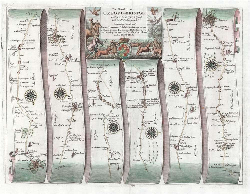
This is John Ogilby's road map detailing the road between the cities of Oxford and Bristol. It is a strip-map, following the road from Oxford south and west in six lengths, presented as if on a single, unspooled sheet of paper. Smaller towns, bridges, forests, churches, and county borders are all noted along the way. Pastures, and even some coal mines are marked as well. Strip maps served to inform travelers of the distances, landmarks, obstacles and resting points along a given road between two destinations. Changes in direction along the way are indicated by the placement of attractive compass-roses. The wise traveler, of course, would never leave the high road; consequently, no further routes would require consideration.
The map's attractive cartouche is embellished with what appears to be a remarkably unsuccessful hunting scene: the mounted hunter, his footmen, and his dogs unable to snare any of the fowl taking wing.
Britannia was based on firsthand survey by Ogilby and his team, who published their results at a uniform scale of one inch to one mile. Of more general importance, Ogilby standardized the English mile throughout his book at 1,760 yards (prior to this, no such uniformity existed in England.) Ogilby's work was the first to utilize strip maps of this kind, but the 18th century would see similar works published by Bowen, Gardner and Senex.
Apps Advise a Different Route
The traveler today consulting a modern, ubiquitous app will be advised to take the A34 south, then switching to the westward M4; this route will bring the Oxford traveler to Bristol in just less than an hour and a half. Ogilby's route via Fyfield, Kingston, Faringdon, Highworth, Cricklade, Malmesbury, Sherston, Luckington, Tormarton, Pucklechurch and Kingswood can be expected to take no less than twenty two hours by foot, and the wise traveler will break this up over several days.Publication History and Census
The map was engraved for inclusion in Ogilby's Britannia, Volume the first: or, an Illustration of the Kingdom of England and Dominion of Wales, printed by the author in 1675. The work was reprinted in 1698 with minor changes (including the page numbers on the maps, as is exhibited here. Both editions are well represented in institutional collections. An example of the 1675 issue of this map has been catalogued by Yale University.Cartographer
John Ogilby (November 17, 1600 - 1676) was a Scottish translator and cartographer. John Ogilby's life seems to be one of extremes, teetering between wealth and poverty, success and failure. Ogilby was born near Edinburgh, Scotland, into a once wealthy family laid low by extreme debt. Struggling with poverty at every turn, Ogilby involved himself in various businesses ranging from dancing master, to actor, to tutor. In 1612, at age 12, Ogilby won a lottery run to advance the colonial interests of Virginia. His winning were sufficient to pay of many of his father's debts and apprentice himself to a dancing master. Ogilby proved a natural and graceful dancer and even made extra money tutoring his fellow apprentices. Starcrossed as he was, Olgiby's dancing career ended when a misstep when a misstep at a masked ball injured his leg and left him lame for live. Afterwards he managed to leverage his contacts in the dance world to secure a position as a dance instructor to the daughters of Sir Ralph Hopton. Hopton struck an immediate friendship with Olgiby and trained him in Military Science. Later Ogilby relocated to Ireland where he worked an as actor and later as Master of Revels. The Irish Rebellion of 1641 again dashed Ogilby's fortunes and forced him to flee Dublin by ship. On the way, the ship sunk but the survivors were rescued and eventually made their way to England, which was then under the strict rule of Oliver Cromwell. Ogilby took refuge at Cambridge where he mastered Greek and Latin. Following the Restoration of Charles II, Ogilby invested in his first major literary venture, a translation of Virgil into English. This work earned him the patronage of Charles II, despite the ridicule of prominent poets Dryden and Pope. Under Royal patronage Ogilby published several volumes relating to the Restoration. In short order he has established a successful London publisher based out of the Whitefriars district. This, unfortunately turned out to be a fateful choice of location as in 1666 the Great Fire of London tore through this are destroying Ogilby's publishing stock, home, and business. Once again Ogilby exhibited a remarkable phoenix-like ability to literally rise from the ashes. Shortly after the Great Fire, he began his most important ventures as a publisher of geographical works. In order to recover from the fire, Ogilby and his grandson were took positions as surveyors commissioned to create a large property map of London. The resultant map of London, "London Survey'd", was published in 1677 and earned Ogilby the honorific "Kings Cosmographer and Geographic Printer". His most famous works are his 1675 Road Atlas of England, Britannia which redefined road mapping, and his 1671 Atlas of the Americas. More by this mapmaker...
Source
Ogilby, J. Britannia (London: Swall) 1698.
Condition
Very good. Reinforced area of scuffing with faint loss.
References
OCLC 1164792734.