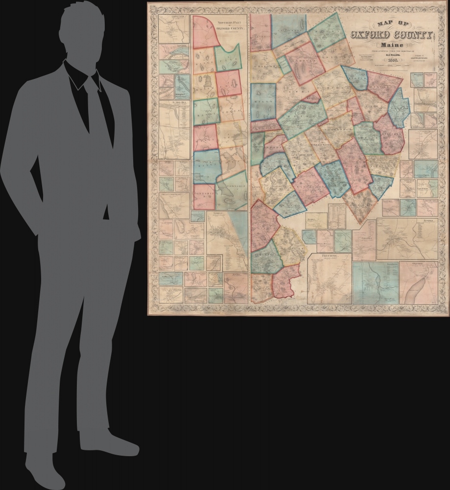
1858 Walling Wall Map of Oxford County, Maine
OxfordCoMaine-walling-1858$2,750.00


Title
Map of Oxford County Maine.
1858 (dated) 59 x 56 in (149.86 x 142.24 cm) 1 : 72000
1858 (dated) 59 x 56 in (149.86 x 142.24 cm) 1 : 72000
Description
A superb example of H. F. Walling's 1858 wall map of Oxford County Maine. Composed of much of Maine's western border, the map embraces parts of the beautiful Rangeley Lakes Region, including Mooselookmeguntic Lake and the adjacent Richardson Lakes.
A Closer Look
The map breaks the tall county into northern and southern sections, both covering from the New Hampshire border to neighboring counties to the east. It contains an astounding 51 detail maps of Oxford County towns and villages. Like most Walling maps, individual property owners are meticulously detailed throughout.Rangeley Lakes
The Rangeley Lakes, nestled within the mountains of western Maine, represent a breathtaking tapestry of glacial water bodies renowned for their stunning beauty and rich history. Spanning a series of major lakes including Rangeley, Mooselookmeguntic, and Cupsuptic, this region has been a sought-after destination for fishing, boating, hiking, and kayaking. Famed for its native brook trout and landlocked salmon, the lakes have long drawn anglers hopeful for a prized catch. Beyond its natural allure, the Rangeley Lakes area, with its charming towns and rustic lodges, stands as a testament to Maine's enduring connection to the wilderness, offering both solitude and adventure for those who seek it.Publication History and Census
This map was compiled by H. F. Walling and published in 1858 by the New York firm Gillette and Huntington. We note 5 examples in OCLC. Scarce to the market.CartographerS
Henry Francis Walling (June 11, 1825 - April 8, 1889) was an American civil engineer, cartographer, surveyor, and map publisher active from the middle to late 19th century. Walling was born in Providence, Rhode Island. He studied/worked at the Providence Athenaeum before discovering a talent for mathematics and surveying. Walling took a position with Samuel Barrett Cushing (1846 - 1888), a Providence-based civil engineer with whom he issued in 1846 a revision of James Steven's Topographical Map of the State of Rhode-Island. Walling established himself independently around 1850 and immediately began preparing a series of town plans focusing on Bristol County, near Providence. Buoyed by widespread interest in his plans, Walling expanded his operations to Massachusetts, where, by 1857, he had produced no less than 50 town plans. Apparently, Walling's business model involved a contract with town officials to produce a certain number of maps, after which he acquired the right to print and sell additional copies on his own account. This work eventually led to Walling's appointment as Massachusetts "Superintendent of the State Map", a designation that began appearing on his maps around 1855. While Walling's work focused heavily on city and county maps, he successfully published three scarce state maps: Maine, Vermont, and Rhode Island. In 1856, Walling relocated his headquarters to New York City, where he had better access to quality lithographers. The Civil War (1861 - 1865) proved difficult for Walling, and diminished sales may have forced him into a partnership with Ormando W. Gray, with whom he published numerous state, county, and national atlases in the 1860s and 1870s. Around 1880, Walling took a post with the U.S. Coast Survey, with whom he worked on various charts until requesting a transfer in 1883 to the newly formed U.S. Geological Survey. Walling remained with the Geological Survey until his untimely death of a heart attack in April 1889. More by this mapmaker...
John Edward Gillette (1828 - March 10, 1911) was an American map publisher. Gillette published several county maps of New York as well as a map of the vicinity of Philadelphia. Gillette died in Hudson, New York. Per his obituary, Gillette 'is best remembered as the organizer of the American Paper Car Wheel Company, whose process of making wheels of pressed paper was successful from the start'. Learn More...
Francis Junius Huntington (December 3, 1802 - February 5, 1878) was an American publisher of books and later music. Born in Suffield, Connecticut, Huntington was the son of Hezekiah Huntington, who fought in the American Revolutionary War (1775 - 1783), worked as a prominent attorney in Connecticut after the war, and was appointed District Attorney for Connecticut by President Thomas Jefferson in 1806. Francis Huntington grew up in Hartford, Connecticut. He entered the publishing world in Hartford at a young age and soon found success in his chosen field as a bookseller, printer, and publisher. Atlases, geography books, and textbooks were among the many works he published. He moved to New York City in 1862 where he began publishing musical books. He died in New York in 1878. He married Stella Bradley Bull on September 1, 1833, with whom he had seven children, three of which died in childhood. Learn More...
Condition
Very good. Full professional restoration. Fresh linen backing.
References
Library of Congress G3733.O8 1858 .W3. OCLC 57508574.