1589 Abraham Ortelius Map of the Pacific Ocean
Pacific-ortelius-1589$17,500.00

Title
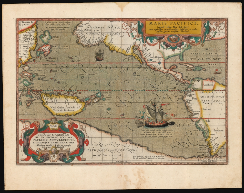
Maris Pacifici (quod vulgo Mar del Zur).
1589 (undated) 13.5 x 19.5 in (34.29 x 49.53 cm) 1 : 41200000
1589 (undated) 13.5 x 19.5 in (34.29 x 49.53 cm) 1 : 41200000
Description
This is Abraham Ortelius' 1589 map of the Pacific; here is the best example to appear on the market in recent years, with a strong strike and fine original color. Abraham Ortelius' map is as important as it is beautiful - Burden hailed it as 'one of the most important maps that appeared in the Ortelius atlases' and 'one of Ortelius' most desirable maps'. The map is not only the first to focus on the Pacific Ocean, but it is also the first acquirable map to separately identify North and South America.
Japan appeared in no fewer than five configurations in the pages of Ortelius' atlas over the long course of its publication. The 'turtle' shape of Japan on the present map was unique among these, having been drawn from the manuscript charts (c. 1568 - 1580) of Portuguese cartographer Fernão Vaz Dourado. This delineation of Japan was thus one of the first to be based on a firsthand European report.
Another first is the appearance of the Isla de Plata [Island of Silver] to the north of Japan. As early as 1584, the Spanish captain Francisco Gali reported that Chinese harbor pilots claimed the islands north of Japan abounded in precious metals. Ortelius' recording of the Isla de Plata is thus based on one of the few fresh reports of these distant lands to reach Europe.
A Closer Look
Ortelius' map was the first to place the Pacific Ocean at its center; thus, its scope is unique. The map reaches from 60° north to a little further than 60° south; it ranges from the Philippines and China at its western extent to just beyond the Strait of Magellan. The map is among Ortelius' finest compositions, matchless in its balance and artistry. It sports two elegant strapwork cartouches, and its stippled oceans are sailed by three ships. One of these, particularly grand, represents Magellan's flagship Victoria. This last is accompanied by a valedictory verse dedicated to the ship, 'I deserved to be named Victoria: Sails were my wings; my prize was glory; my war was with the sea.'China, Japan and the 'Isla de Plata'
The northwest corner of the map is taken up with China; the Great Wall appears; the Korean peninsula does not.Japan appeared in no fewer than five configurations in the pages of Ortelius' atlas over the long course of its publication. The 'turtle' shape of Japan on the present map was unique among these, having been drawn from the manuscript charts (c. 1568 - 1580) of Portuguese cartographer Fernão Vaz Dourado. This delineation of Japan was thus one of the first to be based on a firsthand European report.
Another first is the appearance of the Isla de Plata [Island of Silver] to the north of Japan. As early as 1584, the Spanish captain Francisco Gali reported that Chinese harbor pilots claimed the islands north of Japan abounded in precious metals. Ortelius' recording of the Isla de Plata is thus based on one of the few fresh reports of these distant lands to reach Europe.
Philippine and East Indian Cartography
After having neglected the Philippines on his earlier maps (following Mercator), Ortelius began to name the archipelago on 1587 and later states of his maps of the World and China. This map follows suit, improving on Ortelius' 1570 map of the East Indies. Ortelius also includes the Moluccas (Spice Islands) and a massive insular New Guinea. This is also one of the first maps to indicate any of the islands of Micronesia.The West Coast of the Americas
Ortelius' map represents a high watermark in the mapping of the American West Coast before the geographic world plunged into the folly of California-as-an-island. Compared with Ortelius' other maps and those of his contemporaries, the mapping here is unique. Wagner described this map's configuration as 'a distinct departure; being unlike any other map ... published before 1589.' It is unclear whether this is due to records of an unknown voyage or is a reinterpretation of existing works. While the American interior is given scant detail - the focus is here on the ocean, after all - there is a reference to the mythical land of Quivira, one of the golden lands sought in America by the Conquistadors Coronado and de Soto. Other broad regions - California, New Spain, Peru, Chile, and Patagonia - are named.The Speculative Southern Continent
The southern extreme of the map is dominated by an enormous continent identified as Terra Australis Sive Magellanica, Nondum Detecta [The Southern Land or Magellanica Not Yet Discovered]. This massive continent was postulated in antiquity by no less than Plato, who belied it must exist to counterbalance the weight of Europe and Asia, and modern geographers - Mercator and Ortelius prominent among them - maintained that belief in the absence of any contact with Antarctica by actual explorers. Ortelius' Magellanica is shown here to begin at the Strait of Magellan (Tierra del Fuego being part of the southern continent.) This southern shore of the Pacific spans westward, reaching as far north as the Tropic of Capricorn. There, it is shown very close to, but separate from a large New Guinea (in this respect conforming to Ortelius' map of the world, rather than his map of the Western Hemisphere, which connected New Guinea to Terra Australis.)Questions of Precedence
Maris Pacifici shares many of its features in the West Pacific with another map, also executed in or just after 1589. Its depictions of Japan, the Isla de Plata, and New Guinea closely resemble those of Frans Hogeberg's Americae et Proximarum Regionum orae Descriptio, including the descriptive text accompanying those features. It is inescapable that either one of these maps was drawn from the other, or that they shared a mutual source. Hogenberg and Ortelius had a long working relationship: Hogenberg engraved many of Ortelius' maps, and it is possible that they worked on these maps in concert. The presentation of the Americas on Hogenberg's map does not resemble Ortelius' here, and was derived from Ortelius' 1587 map of the Western Hemisphere. Richard Casten and Thomas Suárez made a study of these, as well as a third map by Giovanni Mazza, and it is their determination that the Hogenberg likely predated Ortelius' map if only narrowly, with the Mazza appearing after the others. But neither of the competing maps show the Philippines or Moluccas. Nonetheless, as both the Mazza and the Hogenberg are of impossible rarity, the present work remains, for most intents and purposes, the earliest to show the features the three maps share.Publication History and Census
This map was engraved in 1589 and first appeared in the 1590 Latin edition of the Ortelius atlas. It remained in all following editions. The present example conforms typographically with the 1595 Latin edition of the Theatrum. Eight examples of this edition of the complete atlas are cataloged in OCLC. The separate map in its various editions is well represented in institutional collections, although we see only four examples of this edition. It is, moreover, exceptionally rare to find an example with such extraordinary original color - if this map is on your radar, this is the example you want.Cartographer
Abraham Ortelius (April 14, 1527 - June 28, 1598) also known as Ortels, was a cartographer, geographer, and cosmographer of Brabant, active in Antwerp. He was the creator of the first modern atlas, Theatrum Orbis Terrarum and is a seminal figure in the history of cartography. Along with Gerard Mercator and Gemma Frisius, he was a founder of the Netherlandish school of cartography. His connections with Spain - culminating in his 1575 appointment as Royal Cartographer to King Phillip II of Spain - gave him unmatched access to Spanish geographical knowledge during a crucial period of the Age of Discovery. Ortelius was born in 1527 in Antwerp. In 1547 he entered the Antwerp Guild of Saint Luke as an illuminator of maps. He began trading in books, prints, and maps, traveling regularly to the Frankfurt book and print fair, where in 1554 he met Mercator. He accompanied Mercator on journeys throughout France in 1560 and it was at this time, under Mercator's influence, that he appears to have chosen his career as a scientific geographer. His first published geographic work appeared in 1564, an eight-sheet cordiform world map. A handful of other maps preceded the 1570 publication of the first edition of the Theatrum Orbis Terrarum, which would prove to be his life work. Appearing with but 53 maps in its first edition, Ortelius' work expanded with new maps added regularly. By 1592, it had 134 maps. Many of Ortelius' maps remained the standard for nearly a century. He traveled extensively, but his genius was as a compiler, locating the best informed maps on which to base his own. His contacts throughout Europe and extending even (via the Portuguese) to the Far East were formidable. Moreover, many of his maps were based on his own scholarship, particularly his historical works. His theories of geography were particularly ahead of his time with respect to the notion of continental drift, the possibility of which he mused on as early as 1596, and which would be proven correct centuries later.
In a sense his greatest achievement was his successful navigation of the religious and political violence endemic to his city throughout his adult life: The Dutch Revolt, or Eighty Years' War (1568 - 1648), fully embroiled Antwerp. Although outwardly and officially recognized as Catholic (Arias Montanus vouched for Ortelius' Catholic orthodoxy prior to his appointment as Royal Geographer), Ortelius was able to separate himself from the religious furor which characterized the war in the low countries. Ortelius showed a glimpse of himself in a letter to a friend, regarding humanist Justus Lipsius: 'I do not know whether he is an adherent of the Pope or a Calvinist, but if he has ears to hear, he will neither be one nor the other, for sins are committed on both sides'. Ortelius' own explorations of Biblical history in his maps, and the Christogram contained in his own motto, suggest him to be a religious man, but his abjuration of political religious authorities mark him as an individualist. His tombstone at St Michael's Præmonstratensian Abbey in Antwerp bears the inscription, Quietis cultor sine lite, uxore, prole. ('served quietly, without accusation, wife, and offspring.') More by this mapmaker...
Source
Ortelius, A., Theatrum Orbis Terrarum, (Antwerp: Ortelius) 1595.
Abraham Ortelius' magnum opus, Theatrum Orbis Terrarum, was the world's first regularly produced atlas, which 'set the standards for later atlases . . . It was the first undertaking of its kind to reduce the best available maps to an uniform format.' (Koeman) A modestly-sized work of fifty-three maps in its first edition of May 1570, it was an immediate success: there were three further editions that year, and the work remained in print for a total of 32 editions, the last of which was 1641, well after its author's 1598 death. Ortelius added to his atlas constantly, and by 1595 the Theatrum contained 147 maps. Ortelius is renowned generally as an editor, and indeed much of the Theatrum is compiled from a variety of sources: in such cases, Ortelius was scrupulous in naming his sources. But Ortelius was also a mapmaker in his own right: many of his maps are a distillation of various sources into his own work, and there were many maps - particularly in his atlas of Biblical and ancient history Parergon - which were entirely Ortelius' work. In his role as an editor, Ortelius followed in the footsteps of Munster, whose Cosmographia was, until Ortelius, the best window on the world for the curious European reader. In terms of the artistry of his maps, Ortelius oversaw the first great flourishing of copperplate engraving in the service of cartography to occur in Northern Europe. Ortelius' work provided the model for the atlases of Mercator, Hondius, Blaeu and all their progeny in the 17th century - many of whom were to produce faithful editions of Ortelius' maps in their own productions.
Condition
Excellent. Some marginal staining well away from printed image. Superb original color, generous margins and a bold strike.
References
OCLC 551921065. Rumsey 10001.067 (1608 edition). van den Broecke, M. Ortelius Atlas Maps: An illustrated Guide (second edition) #12. Burden, P. The Mapping of North America #74. Wagner, H. Cartography of the Northwest Coast p. 74, no. 156.