This item has been sold, but you can get on the Waitlist to be notified if another example becomes available, or purchase a digital scan.
1911 Waterlow Map of the World and the British Telegraph Network
PacificCableRoute-waterlow-1911$550.00

Title
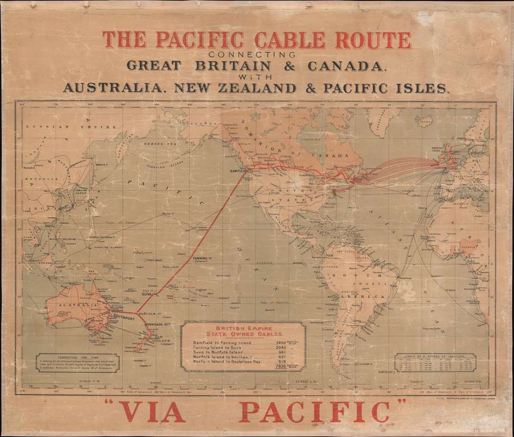
The Pacific Cable Route Connecting Great Britain and Canada with Australia, New Zealand, and Pacific Isles.
1911 (undated) 26.5 x 31.25 in (67.31 x 79.375 cm) 1 : 42000000
1911 (undated) 26.5 x 31.25 in (67.31 x 79.375 cm) 1 : 42000000
Description
This is a c. 1911 John Waterlow and Sons map of the world highlighting British government telegraph cables. Known as the 'All Red Line', this vast telegraph network linked the entirety of the British Empire, allowing for near instant global communication with even the most remote outposts of the empire. This map was issued to celebrate the trans-Pacific cable, linking Vancouver, British Columbia, to Southport, Australia.
The All Red Line is Secure
The All Red Line was the central nervous system of the British Empire. As a rule, operating stations were situated exclusively in well defended British controlled territory. For example, when planning the trans-Pacific cable, the British knew they would need an operating station somewhere in the middle of Pacific, leading to the annexation and fortification of Fanning Island. In 1911, with war in Europe on the horizon, the Committee of Imperial Defence performed a security study of the All Red Line. They noted that to cut Britain off from its empire, forty-nine cables would need to be cut. Fifteen cables would have to be severed to isolate Canada alone, and five to cut off South Africa. Further, it was pointed out that British owned or controlled all equipment needed to cut or repair these cables. Throughout World War I (1914 - 1918), British communications operated unhindered, while the British easily severed the less robust German network.Publication History and Census
This map was created and published by John Waterlow and Sons c. 1911. We note only a single other example, at the National Library of Australia.Cartographer
Waterlow and Sons (1810 - 1961) was a British engraving and printing concern active in London specializing in currency, postage stamps, bond certificates, and occasionally maps. The firm was founded by James Waterlow (1790 - 1876) in 1810 on Birchin Lane, London, as a legal document printer and copyist. By 1852, they had expanded into stamps and his sons, Albert, Alfred, Sydney, and Walter joined the business. One year after James Waterlow's death, in 1877, infighting among the sons led Alfred Waterlow to split off, forming Waterlow Brothers and Layton. The rift was settled by 1920, and the two firms once again merged under the Waterlow and Sons imprint. They were involved in the Portuguese Bank Note Affair of 1925, wherein the Portuguese fraudster Artur Virgílio Alves Reis convinced the firm to print 200,000 banknotes of 500 Portuguese Escudos each, amounting to roughly 88% of Portugal's GDP. The affair was settled in court with a ruling against Waterlow. In 1928, Waterlow lost its most lucrative contract, printing English banknotes, and began to fall into decline. In 1961, they were acquired by Purnell and Sons who, shortly afterwards, sold the firm to De La Rue. Ironically, De La Rue acquired the contract to print Bank of England banknotes again in 2003 – 75 years after Waterlow lost it! More by this mapmaker...
Condition
Good. Full professional restoration. Mounted on linen. Exhibits cracking throughout. Overall toning.
References
OCLC 824510606.