1942 Turner Map of the Pacific and East Asia During World War II
PacificFarEastSecond-turner-1942$450.00

Title
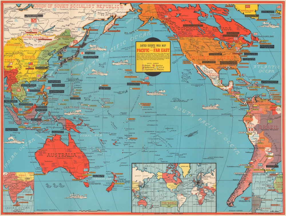
Dated Events War Map of the Pacific and Far East.
1942 (undated) 19.75 x 26.125 in (50.165 x 66.3575 cm) 1 : 38000000
1942 (undated) 19.75 x 26.125 in (50.165 x 66.3575 cm) 1 : 38000000
Description
This is a January 1942 Stanley Francis Turner Dated Events War Map of the Pacific and East Asia, published less than a month after the Japanese attack on Pearl Harbor. Turner produced the 'Dated Events War Map' series throughout World War II (1939 - 1945), creating more than 25 maps, which, as a whole, present a comprehensive cartographic overview of war events as they unfolded. The present map is the Second Edition, the earliest 'Dated War Events' map we have encountered - we've never seen the first issue.
Aside from war-related content, cities and towns fill the map. The map also references natural resources key to the war effort, including oil, rubber, iron, copper, manganese, rice, and tea. Three insets appear along the bottom border: British India, a world map, and the transatlantic route between Natal, Brazil, and Dakar, French West Africa (now Senegal).
A Closer Look
Coverage embraces from Lhasa, Tibet, and Rangoon, Burma (now Yangon) to Reykjavik, Iceland, and from the Arctic Circle to Cape Horn. Black textboxes mark events in the Pacific War from August 1940 (August 20, 1940, U.S.A. leases British ports for joint defense) through January 1942 (January 4, 1942, Chinese victory at Changsha). Most of the referenced events postdate the December 7, 1941, Japanese attack on Pearl Harbor. Earlier events include Japan joining the Axis (September 27, 1940), President Franklin D. Roosevelt signing the Lend-Lease Act (March 11, 1941), and the Vichy French surrender of Indochina to the Japanese (July 24, 1941). American, British, Dutch, French, Japanese, and Russian naval bases are marked using specific symbols for each nation. Illustrations of warships and military airplanes fill the Pacific. Color is used to highlight parts of the world under the direct control of the Americans (orange), British (red), and Japanese (black for the Home Islands and Korea and green for the occupied territory, including Manchukuo and French Indochina). Flags also help identify which country controls which territory.Aside from war-related content, cities and towns fill the map. The map also references natural resources key to the war effort, including oil, rubber, iron, copper, manganese, rice, and tea. Three insets appear along the bottom border: British India, a world map, and the transatlantic route between Natal, Brazil, and Dakar, French West Africa (now Senegal).
Publication History and Census
This map was created by Stanley Francis Turner, printed by R. G. McLean Limited, and published in 1942 by C.C. Petersen. We note 2 examples cataloged in OCLC: University of Houston and the University of Wyoming. An example is also part of the David Rumsey Map Collection. It ranks among the scarcest of Turner's Dated Events maps. This is the first time we have handled an example.CartographerS
Stanley Francis Turner (1883 – 1953) was a visual artist and painter based in Toronto, Canada. Turner was born in Aylesbury, England. He studied art in London at the South Kensington School before migrating to Canada in 1903, where he studied at Ontario College of Art under George Reid and J. W. Beatty. Turner is best known as a painter and designer capable of working in a variety of mediums. During World War II, Turner took a contract with the Globe and Mail to illustrate pictorial maps of war events. Turner may have maintained the rights to his war maps, as he also seems to have had a contract with the advertiser and publisher, C.C. Peterson, also of Toronto, to publish and distribute his maps in the United States. Turner's maps are information dense and designed to illustrate the events of the war in an easily digestible pictorial format. Turner experimented with different ways of working with the cartographic ranging from simple Mercator projections to more contemporary equal-area projections. In 1930, Turner was elected an Associate of the Royal Canadian Academy of Arts. He died in Toronto in 1953. More by this mapmaker...
C. C. Peterson (fl. c. 1940 – 1950) was an advertising and publishing company based in Toronto Canada, but with distribution and licensing in both the United States and Canada. Peterson had contracts with the artist Stanley Francis Turner to publish pictorial 'war maps' during World War II. The company supplemented its income by selling advertisements on Turner's maps. Learn More...
Condition
Very good. Light wear along original fold lines. Light creasing.
References
Rumsey 10407.000. OCLC 48181730.