This item has been sold, but you can get on the Waitlist to be notified if another example becomes available, or purchase a digital scan.
1883 Imray Nautical Map of the Pacific Northwest: Washington, Vancouver, etc.
PacificNorthwest-imray-1883$600.00


Title
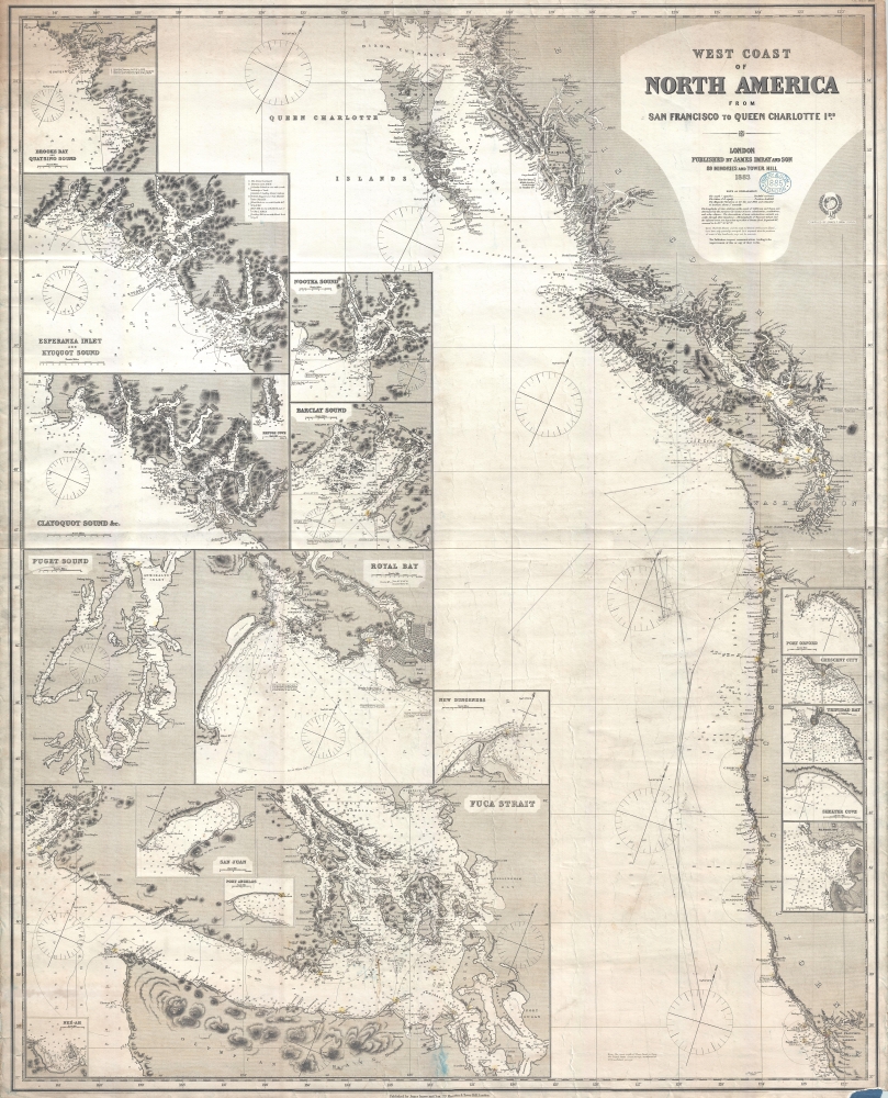
West Coast of North America from San Francisco to Queen Charlotte Ids.
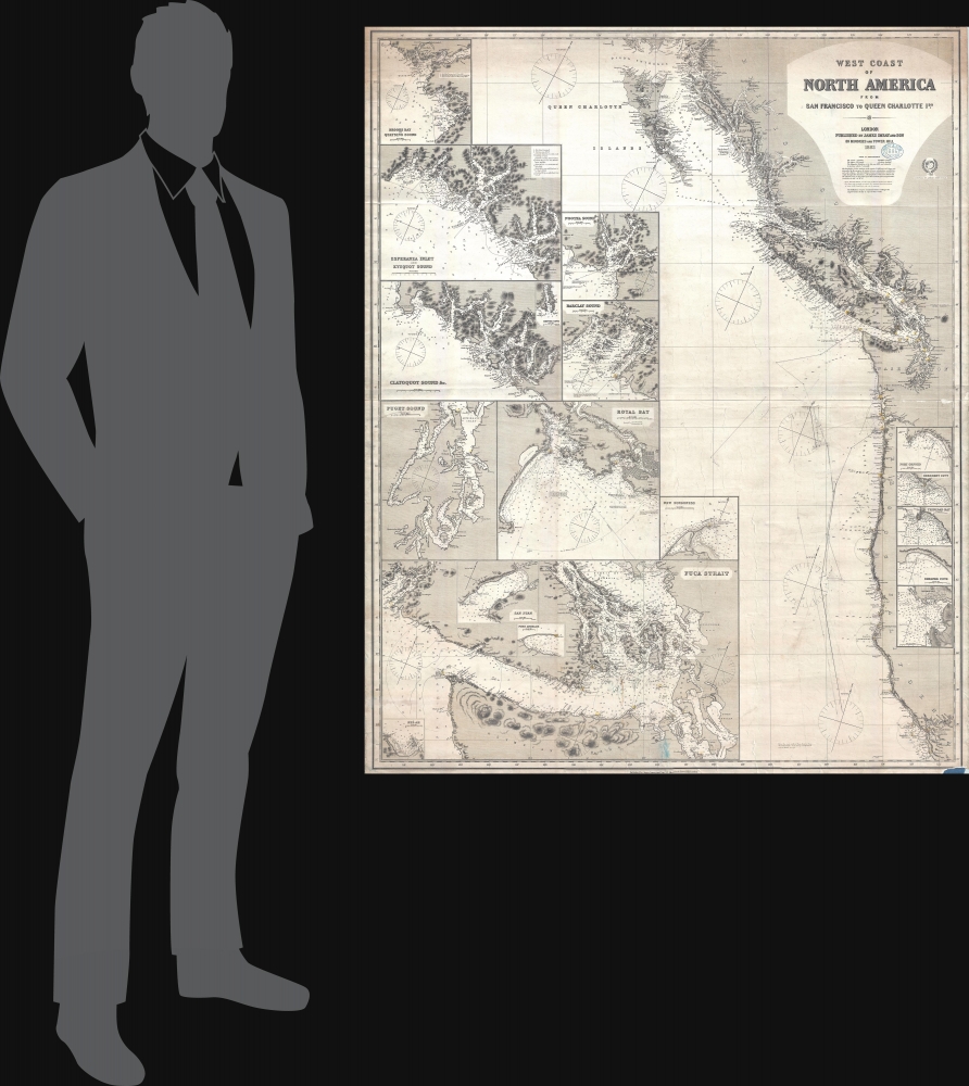
1883 (dated) 50.5 x 41 in (128.27 x 104.14 cm) 1 : 540000
1883 (dated) 50.5 x 41 in (128.27 x 104.14 cm) 1 : 540000
Description
A finely executed 1883 James Imray working nautical map of the American Pacific Northwest from San Francisco to the Queen Charlotte Islands. The map includes San Francisco Bay, Vancouver Island, the Strait of Juan de Fuca, the Columbia River and Astoria, and the coasts of Washington, Oregon, northern California, and British Columbia. Pencil manuscript annotations illustrate the route of a merchant ship, probably a fur trader, between the Columbia River frontier trading settlement of Astoria and San Francisco.
A Wealth of Insets
The map features eighteen detailed inset sub-maps including Fuca Strait, Neé-ah, San Juan, Port Angelos, Puget Sound, Royal Bay, Clayoquot Sound, Barclay Sound, Nootka Sound, Esperanza Inlet and Kyuquot Sound, Broods Bay and Quatsino Sound, Burrard Inlet, Port Orford, Crescent City, Trinidad Bay, Shelter Cove, Mendocino, and Fort Ross Cove.A Change in Branding Bluebacks
This chart is part of a series of large format nautical charts issued by James Imray and Sons in the early 1880s. The charts were part of a branding change that introduced greater consistency in style, size, and form to the mishmash that marked earlier blueback chart production. The new style focused on producing charts of a uniform size with standardized shading and mapping conventions. Without a doubt these changes were intended to make Imray nautical charts more competitive with cheaper, often more accurate, British Admiralty charts.Blueback Charts
Blueback nautical charts began appearing in London in the late 18th century. Bluebacks, as they came to be called, were privately published large format nautical charts known for their distinctive blue paper backing. The backing, a commonly available blue manila paper traditionally used by publishers to wrap unbound pamphlets, was adopted as a practical way to reinforce the low-quality paper used by private chart publishers to cut costs. The earliest known blueback charts include a 1760 chart issued by Mount and Page and a 1787 chart issued by Robert Sayer. The tradition took off in the early 19th century, when British publishers like John Hamilton Moore, Robert Blachford, James Imray, William Heather, John William Norie, Charles Wilson, David Steel, R. H. Laurie, and John Hobbs, among others, rose to dominate the chart trade. Bluebacks became so popular that the convention was embraced by chartmakers outside of England, including Americans Edmund March Blunt and George Eldridge, as well as Scandinavian, French, German, Russian, and Spanish chartmakers. Blueback charts remained popular until the late 19th century, when government subsidized organizations like the British Admiralty Hydrographic Office and the United States Coast Survey, began issuing their own superior charts on high quality paper that did not require reinforcement.Publication History and Census
This map was created and published by James Imray and Son in 1883. We note three examples cataloged in OCLC which are part of the collections at the William Clements Library at the University of Michigan, the University of British Columbia, and the University of California Berkeley. We note cataloged editions of this map dating from 1868 and 1887.Cartographer
James Imray (May 16, 1803 - November 15, 1870) was a Scottish hydrographer and stationer active in London during the middle to latter part of the 19th century. Imray is best known as a the largest and most prominent producer of blue-back charts, a kind of nautical chart popular from about 1750 to 1920 and named for its distinctive blue paper backing (although not all charts that may be called "blue-backs" actually have a blue backing). Unlike government charts issued by the British Admiralty, U.S. Coast Survey, and other similar organizations, Imray's charts were a private profit based venture and not generally the result of unique survey work. Rather, Imray's charts were judicious and beautiful composites based upon pre-existing charts (some dating to the 17th century) and new information gleaned from governmental as well as commercial pilots and navigators. Imray was born in Spitalfields, England, the eldest son of a Jacobite dyer also named James. Imray did not follow his father profession, instead apprenticing to William Lukyn, a stationer. He established himself as a bookseller and bookbinder at 116 Minories Street, where he shared offices with the nautical chart publisher Robert Blanchford. In 1836 Imray signed on as a full partner in Blanchford's enterprise, christening themselves Blanchford & Imray. At this time the Blanchford firm lagged far behind competing chart publishers Norie and Laruie, nevertheless, with the injection of Imray's marketing savvy the firm began a long rise. James Imray bought out Blanchford's share in 1846, becoming the sole proprietor of the chart house, publishing under the imprint of James Imray. Relocating in 1850 to larger offices at 102 Minories, Imray was well on track to become the most prominent chart publisher in London. In 1854, when Imray's 25 year old son, James Frederick Imray, joined as a full partner, the firm again changed its imprint, this time to James Imray and Son. The elder Imray was a master of marketing and was quick to respond to trade shifts and historic events. Many of his most successful charts were targeted to specific trade routes, for example, he issued charts entitled "Cotton Ports of Georgia" and "Rice Ports of India". Other charts emerged quickly following such events as the 1849 California Gold Rush. Imray's rise also coincided with the development of governmental mapping organizations such as the Admiralty and the U.S. Coast Survey, whose work he appropriated and rebranded in practical format familiar to navigators. Imray's death in 1870 marked a major transition in the firm's output and began its decline. Though Imray's son, James Frederick, excelled at authoring pilot books he had little experience with charts and issued few new publications. Most James Frederick Imray publications issued from 1870 to 1899 were either revisions of earlier maps prepared by his father or copies of British Admiralty charts. Charts from this period are recognizable as being less decorative than the elder Imray's charts following the stylistic conventions established by the Admiralty. The Admiralty itself at the same time began to rise in prominence, issuing its own official charts that were both cheaper and more up to date than those offered by private enterprises. By the end of the century the firm was well in decline and, in 1899 "James Imray and Son" amalgamated with the similarly suffering "Norie and Wilson", which was itself acquired by Laurie in 1904. Today it continues to publish maritime charts as "Imray, Laurie, Norie and Wilson". More by this mapmaker...
Condition
Very good. Minor soiling. Overall toning. Chip lower right. Pencil annotations related to navigation. Working nautical chart.
References
OCLC 1017079019.