This item has been sold, but you can get on the Waitlist to be notified if another example becomes available, or purchase a digital scan.
1818 Franz Pluth Map of the Pacific Coast of North America
PacificNorthwest-pluth-1818$112.50

Title
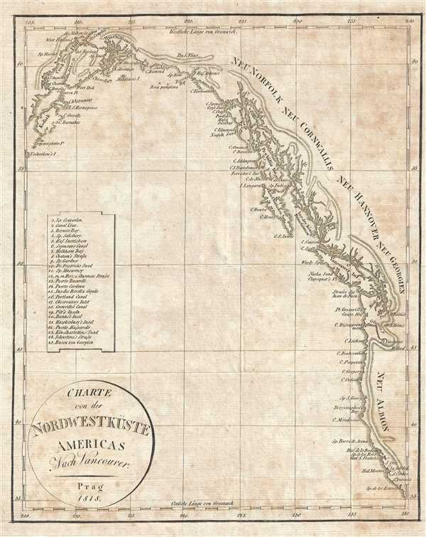
Charte von der Nordwestküste Americas Nach Vancouver.
1818 (dated) 10 x 8 in (25.4 x 20.32 cm) 1 : 12000000
1818 (dated) 10 x 8 in (25.4 x 20.32 cm) 1 : 12000000
Description
This is an 1818 Franz Pluth Map of the Pacific coast of North America. The map depicts the region from Kodiak Island and Cook Inlet in Alaska along the Canadian coastline to Washington, Oregon, and California in the United States. Numerous locations along the coastline are labeled, including Prince William Sound, Prince of Wales Island, Vancouver Island, Puget Sound, the Columbia River, San Francisco Bay, and Monterey Bay. Sir Francis Drake was the first to name the west coast of the United States New Albion when he arrived in what is now northern California in 1579. He chose the name for two reasons: first, because the coastline evoked images of the English coastline in his view, and because Albion was an archaic word by which the island of Great Britain was once known. Twenty-five locations are numerically identified along the coastline and correspond with an index situated along the left border.
This map was produced by Franz Pluth in 1818.
This map was produced by Franz Pluth in 1818.
Cartographer
Franz Pluth (1800 - 1871) was an engraver based in Prague, the capital of the Kingdom of Bohemia, then part of the Habsburg Austrian Empire. Pluth was born in Prague and most likely died in Zbraslav. He was active as a map engraver until at least 1848. His work is similar in style to that of Karl Ferdinand Weiland, a prolific German engraver, with whom he may have worked. More by this mapmaker...
Source
Linder, F. L., Neueste Länder - und Völkerkunde, ein geographisches Lesebuch für alle Stände. , (Prague) 1820.
Linder's book is typically dated 1820, but contains maps dated between 1816 and 1825.
Condition
Very good. Even overall toning. Blank on verso.