1842 Bradford Map of the Pacific Ocean, Oceania
PacificOcean-bradford-1842$250.00

Title
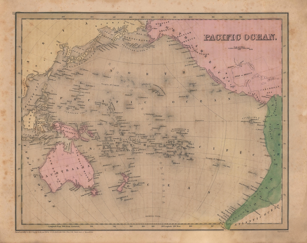
Pacific Ocean.
1842 (undated) 11.5 x 14.25 in (29.21 x 36.195 cm) 1 : 57000000
1842 (undated) 11.5 x 14.25 in (29.21 x 36.195 cm) 1 : 57000000
Description
A beautiful 1842 map of the Pacific Ocean, Australia, and Polynesia by the important American mapmaker T. G. Bradford. Centered on the Sandwich or Hawaiian Islands, it depicts the entirety of the Pacific Basin along with portions of the surrounding continents.
A Closer Look
The map covers from the Bering Strait south as far as Cape Horn and from modern day Vietnam east as far as the Gulf of Mexico. Although the interiors of the continents remain blank, the coastlines are relatively accurate. Borneo is misshapen, though improved considerably from Bradford's 1835 map of the same (previously sold by us), as are the Philippine Islands (see Publication History and Census below). The islands of Polynesia, Melanesia, and Micronesia are noted in remarkable detail, often with names no longer in use and whose origin is mysterious. Some of them appear to be phantom islands. In North America, curious landward features such as the placement of San Francisco and 'Ft. McHenry' reveal the minimal level of geographical knowledge of the continent's western half at the time.Publication History and Census
This map was prepared by Thomas Bradford and engraved by George Washington Boynton. It appeared in the 1842 edition of Samuel Goodrich's reprint of Bradford's Universal Illustrated Atlas. Though dated 1841, the page number at top-left and text offsetting from an opposite page distinguish it from the 1841 state of the map (held by the David Rumsey Historical Map Collection). The present state is quite rare, having no known history in institutional collections or on the market, though that is likely because extant examples are understandably yet incorrectly dated to 1841.CartographerS
Thomas Gamaliel Bradford (1802 - 1887) was born in Boston, Massachusetts, where he worked as an assistant editor for the Encyclopedia Americana. Bradford's first major cartographic work was his revision and subsequent republishing of an important French geography by Adrian Balbi, Abrege de Geographie published in America as Atlas Designed to Illustrate the Abridgment of Universal Geography, Modern and Ancient. Afterwards Bradford revised and expanded this work into his own important contributions to American cartography, the 1838 An Illustrated Atlas Geographical, Statistical and Historical of the United States and Adjacent Countries. Bradford's cartographic work is significant as among the first to record Texas as an independent nation. In his long career as a map publisher Bradford worked with William Davis Ticknor of Boston, Freeman Hunt of New York, Charles De Silver of Philadelphia, John Hinton, George Washington Boynton, and others. We have been able to discover little of Bradford's personal life. More by this mapmaker...
George Washington Boynton (fl. c. 1830 - 1850) was a Boston based cartographer and map engraver active in the first half of the 19th century. Boynton engraved and compiled maps for numerous publishers including Thomas Bradford, Nathaniel Dearborn, Daniel Adams, and S. G. Goodrich. His most significant work is most likely his engraving of various maps for Bradford's Illustrated Atlas, Geographical, Statistical, and Historical, of the United States and the Adjacent Countries and Universal Illustrated Atlas. He also engraved for the Boston Almanac. In 1835, Boynton is listed as an employee of the Boston Bewick Company, an engraving, stereotype, and printing concern based at no. 47 Court Street, Boston. Little else is known of his life. Learn More...
Source
Bradford, T. G. and Goodrich, S. G., A Universal Illustrated Atlas, exhibiting a Geographical, Statistical, and Historical view of the World, (Boston: Charles D. Strong) 1842.
The Universal Illustrated Atlas is one of the great American atlases of the first half of the 19th century. The atlas was first published in 1838 under the imprint of Charles D. Strong. It replaced and superseded Bradford's earlier smaller format Illustrated Atlas, Geographical, Statistical, and Historical, of the United States and the Adjacent Countries. Numerous reissues of the Universal Illustrated Atlas followed until about 1848. Although there are minor variations between the editions, most contain about 50 maps, the majority of which focus on the United States. Bradford's atlases are significant for recording North America during the Republic of Texas Era. In later editions, particularly the 1846 edition, Bradford illustrates the boom in railroad construction, possibly with the idea that his maps would aid travelers in planning journeys by rail. It was compiled by Thomas Gamaliel Bradford and Samuel Griswold Goodrich with most of the plates engraved by George Washington Boynton (fl. c. 1830 - 1850). Other contributors include Thomas Gordon (1778 - 1848), Fielding Lucas Jr. (1781 - 1854), Samuel Edward Stiles (1844 - 1901), Sherman and Smith (fl. c. 1829 - 1855), and Horace Thayer (1811 - c. 1874).
Condition
Good. Light foxing. Some offsetting present.
References
Rumsey 4453.049 (1841 edition), OCLC 957467845 (1841 edition).