This item has been sold, but you can get on the Waitlist to be notified if another example becomes available, or purchase a digital scan.
1870 Andriveau-Goujon Map of Palestine - Israel
Palestine-andriveau-1870$130.00

Title
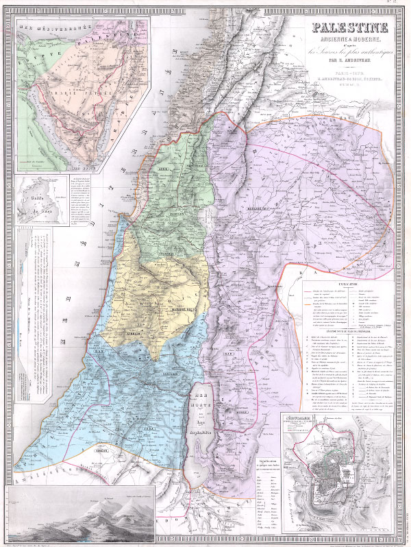
Palestine Ancienne & Moderne d’apres les Sources les plus Authentiques.
1870 (dated) 19 x 25 in (48.26 x 63.5 cm)
1870 (dated) 19 x 25 in (48.26 x 63.5 cm)
Description
An extremely attractive and impressive map 1870 of Palestine, Israel, or the Holy Land by French cartographer E. Andriveau-Gujon. Covers the regions of modern day Israel, Lebanon, Syria, Jordan, and the Sinai in considerable detail. Identifies both archaic and modern place names and offers a wealth of both political and geographical information. In the lower left hand quadrant there is a detailed inset of Jerusalem. The lower left quadrant hosts a comparative elevation chart or mountains chart. Looking to the upper left quadrant we find several insets including a map of the Sinai, a detail of the Gulf of Suez, including depth soundings and ferryboat crossings and a land profile chart of the Mediterranean basin. Published by the French cartographer E. Andriveau-Goujon on Rue de Bac, 21, Paris, France for issue as plate 18 in the 1870 edition of Andriveau-Goujon's Atlas Universel….
Cartographer
Eugène Andriveau-Goujon (1832 - 1897) was a map publisher and cartographer active in 19th century Paris. The firm was created in 1825 when Eugène Andriveau married the daughter of map publisher Jean Goujon - thus creating Andriveau-Goujon. Maps by Andriveau-Goujon are often confusing to identify as they can be alternately singed J. Goujon, J. Andriveau, J. Andriveau-Goujon, E. Andriveau-Goujon, or simply Andriveau-Goujon. This refers to the multiple generations of the Andriveau-Goujon dynasty and the tendency to republish older material without updating the imprint. The earliest maps to have the Andriveau-Goujon imprint were released by Jean Andriveau-Goujon. He passed the business to his son Gilbert-Gabriel Andriveau-Goujon, who in 1858 passed to his son, Eugène Andriveau-Goujon, under whose management the firm was most prolific. Andriveau-Goujon published numerous fine pocket maps and atlases throughout the 19th century and often worked with other prominent French cartographers of the time such as Brue and Levasseur. The firm's stock was acquired by M. Barrère in 1892. More by this mapmaker...
Source
Andriveau-Goujon, E., Atlas Universel. (1870 edition)
Condition
Very good condition. Minor verso reinforcement to centerfold mostly confined to marginal areas. Wide clean margins. Blank on verso.