This item has been sold, but you can get on the Waitlist to be notified if another example becomes available, or purchase a digital scan.
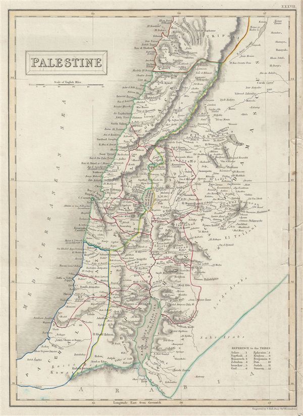
1840 Black Map of Israel, Palestine, or the Holy Land
Palestine-black-1840$75.00

Title
Palestine.
1840 (undated) 16 x 11.5 in (40.64 x 29.21 cm)
1840 (undated) 16 x 11.5 in (40.64 x 29.21 cm)
Description
A fine example of Adam and Charles Black's 1840 map of Palestine or Israel or the Holy Land. The map shows the administrative divisions of the Ottoman empire which include the Pachalic of Gaza, Pachalic of Acre, Pachalic of Damascus and part of the Pachalic of Tripoli. This time in history marks the decline of the Ottoman empire. After the conquest of Palestine by Muhammad Ali's egypt in 1832 following the egyptian-Ottoman War, British intervention returned control of Palestine to the Ottoman rulers in 1840 which lasted till World War I. This map was engraved by S. Hall for issue in the 1840 edition of Black's General Atlas.
Cartographer
Charles and Adam Black (fl. 1807 - present) were map and book publishers based in Edinburgh. Charles and his uncle, Adam, both of Edinburgh, Scotland, founded their publishing firm in 1807. They published a series of maps and atlases throughout the 19th century. In addition to an array of atlases, the Black firm is known for their editions of the Encyclopedia Britannica (1817 - 1826) and the first publishing of Sir Walter Scott's novels in 1854. In 1889 the A. & C. Black publishing house moved to London where it remains in operation to this day. More by this mapmaker...
Source
Hall, Sydney, Black's General Atlas: A series of Fifty-Four Maps from the Latest and Most Authentic Sources, Engraved on Steel, In the First Style of the Art, (Edinburgh: Adam and Charles Black) 1840.
Condition
Very good. Blank on verso. Original platemarks visible. Slight staining. Damage to right margin with verso repair at five places, each extending to approximately 1 inch into right margin.
References
Rumsey 2305.042 (1854 edition). Philips (atlases) 4334.