This item has been sold, but you can get on the Waitlist to be notified if another example becomes available, or purchase a digital scan.
1860 Dufour Map of Palestine, Israel or Holy Land and Sinai w/ 12 Tribes
PalestineJesusChrist-dufour-1860$112.50

Title
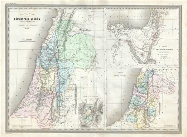
Palestine au temps de Jesus-Christ. Carte de la route suivie par les Hebreux : Depuis Leur Depart de l'Egypte Jusqua leur entree dans le Pays de Chanaam. Carte des Tribus d'Israel.
1860 (dated) 23 x 31 in (58.42 x 78.74 cm) 1 : 1300000
1860 (dated) 23 x 31 in (58.42 x 78.74 cm) 1 : 1300000
Description
This is a beautiful large 1860 elephant folio map by A. H. Dufour. Essentially three maps on a single sheet, the large map on the left depicts Palestine or Israel or the Holy Land during the time of Jesus Christ. The map in the top right quadrant features the Egypt and the Sinai Peninsula and follows the journeys of the Israelites. The third map, in the lower right quadrant depicts the twelve tribes of Israel.
The large map on the left depicts the region during the time of Jesus Crist and includes the routes followed by Christ during the course of his Evangelical Mission. Both ancient and contemporary place names are noted throughout. An inset Plan of Jerusalem is included in the lower right quadrant of this map with all principal buildings identified.
The map in the lower right quadrant coves the region as it existed in Biblical times with divisions for each of the Tribes of Israel and include the modern day nations of Israel, Palestine, Lebanon, as well as parts of adjacent Syria and Jordan. Color coded according to the areas controlled by the Tribes of Israel, from the north these are Aser, Naphtali, Zabulon, Issachar, Manasseh, Ephraim, Benjamin, Dan, Juda, Simeon, Ruben, Gad and Manasseh Beyond Jordan.
The third map in top right quadrant shows the wanderings of the Israelites in the desert- a forty year episode from Exodus. The city of Ramesses is indicated as the starting point of the Biblical Exodus. We can follow their path as they fled out of Egypt, across the Red Sea, and subsequently spent the next forty years wandering the Sinai before migrating into the Promised Land by crossing the Jordan River just north of the Dead Sea.
This map was prepared by Auguste-Henri Dufour and engraved by Charles Dyonette for publication plate no. 1 in Armand Le Chevalier's 1860 edition of Atlas Universel, Physique, Historique et Politique de Geographie Ancienne et Moderne.
CartographerS
Adolphe Hippolyte Dufour (1795 - 1865), also known as Auguste-Henri Dufour, was a Paris based map and atlas publisher active in the middle to late 19th century. Dufour claimed to be a student of another French cartographer, Emile Lapie. He is known to have worked with numerous other French cartographers, publishers, and engravers of the period including Andriveau-Goujon, Charles Dyonnet, and Duvotenay. His corpus includes numerous maps and atlases, the most striking of which is probably his monumental elephant folio Atlas Universel Physique, Historique et Politique Geographie Ancienne et Moderne. Dufour's student and successor was Alexandre Vuillemin. More by this mapmaker...
Charles Dyonnet (fl. c. 1822 - c. 1880) was an extremely active Paris based engraver working in the mid to late 19th century. From his offices at 220 Rue St. Jacques, Paris, Dyonnet engraved numerous maps for many of the most prominent 19th French cartographic publishers including Vuillemin, Dufour, Fremin and Duvotenay. From 1850-1861, he held the coveted position of "Graveur du Dépot de la Marine," and in this position engraved numerous French naval and military maps. Dyonnet had a detail oriented and aesthetically minded hand and is responsible from some of the most beautiful French maps to emerge during the 19th century. Learn More...
Source
Chevalier, A., Atlas Universel, Physique, Historique et Politique de Geographie Ancienne et Moderne, Paris 1860.
The 19th century French cartographer Auguste-Henri Dufour began publishing the dramatic elephant folio Atlas Universel, also occasionally titled Grand Atlas Universal, around 1855. Several editions appeared between its initial publication in the 1850s and a final run c. 1870. The 1863 and 1864 editions in particular are highly desirable among collectors because the United States and North America maps illustrate the proposed, but unrealized, state of Corona (roughly modern day Utah). The atlas contained roughly 40 maps, most of which were engraved by Louis Antoine (the maps) and Deletre (typography) under the supervision of Charles Dyonnet, official engraver of the Depot de la Marine. The Atlas Universal was published in Paris and edited by the firm of 'Paulin et le Chevalier,' 60 Rue Richelieu.
Condition
Very good. Minor wear along original fold lines. Minor spotting at places.
References
Rumsey 5020.004. OCLC Number: 234168571. The National Library of Israel: Pal0546