This item has been sold, but you can get on the Waitlist to be notified if another example becomes available, or purchase a digital scan.
1939 Lites Pictorial Map of Palo Alto, California
PaloAlto-lites-1939$75.00

Title
A Pictorial Map of Palo Alto and the San Francisco Peninsula.
1939 (undated) 17.25 x 22.25 in (43.815 x 56.515 cm)
1939 (undated) 17.25 x 22.25 in (43.815 x 56.515 cm)
Description
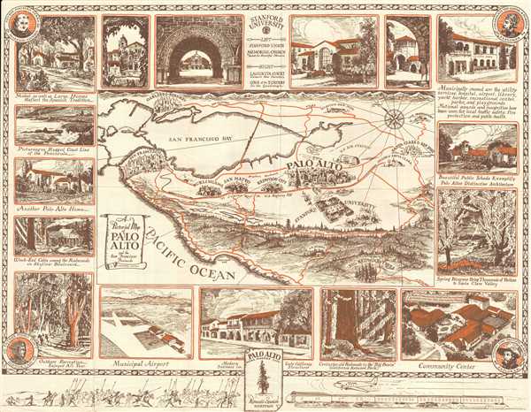
This is a 1939 Arthur Lites pictorial map of Palo Alto, California and the surrounding area. The map depicts the region from the Golden Gate to the Lick Observatory and from Oakland and Berkeley to Half Moon Bay, the Pacific Ocean and some 'big redwood trees.' Numerous locations are labeled throughout the region, including Redwood City, San Mateo, Burlingame, Santa Clara, San Jose, Niles, Hayward, and San Leandro, with the focus falling on Palo Alto. 'Treasure Island', the location of the 1939 Golden Gate International Exposition, is also included and labeled in San Francisco Bay. Highways are illustrated by orange lines, and of those labeled are U.S. Highway 101, 'El Camino Real', Skyline Boulevard, and Bayshore Boulevard. Stanford University occupies an enormous amount of space in comparison to other entities illustrated on the map. Sketches of various locations around Palo Alto create the map's border and feature the municipal airport, the community center, public schools, several buildings on Stanford's campus, a couple of homes, among others. Along the bottom, what appear to be colonial forces face off against modern technology in the form of cars, trains, and an airplane. Portraits of the explorer Colonel Juan Bautista de Anza, the explorer Comandante de Gaspar de Portola, the historian Father Pedro Font and Father Junipero Serra, a founder of a mission, occupy the corners.
This map was created by Arthur Lites and published by the Palo Alto Chamber of Commerce in 1939. The map is dated based on the presence of Treasure Island in San Francisco Bay.
This map was created by Arthur Lites and published by the Palo Alto Chamber of Commerce in 1939. The map is dated based on the presence of Treasure Island in San Francisco Bay.
Condition
Very good. Wear along original fold lines. Text and other content on verso.
References
Rumsey 6792.003.