1765 Isaak Tirion Map of Panama
Panama-tirion-1765$250.00

Title
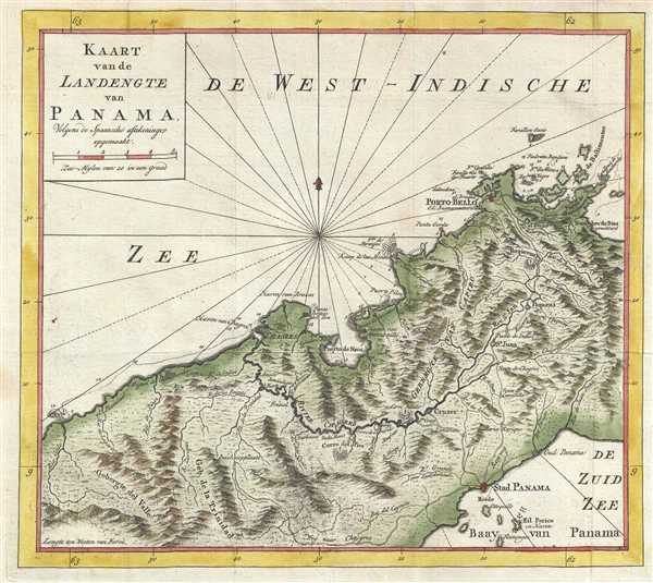
Kaart van de Landengte van Panama. Colgens de Spaansche aftekeninge opgemaakt.
1765 (undated) 10.75 x 12.25 in (27.305 x 31.115 cm) 1 : 450000
1765 (undated) 10.75 x 12.25 in (27.305 x 31.115 cm) 1 : 450000
Description
This is a 1765 Isaak Tirion map of the isthmus of Panama. The map depicts the region from the west, from the Caribbean Sea to the Pacific Ocean. Highly detailed, the map illustrates rivers, streams, bays, roads, and several settlements. Porto-Bello and Panama City are among the labeled settlements. Several mountain ranges are indicated throughout the region. Safe harbors are indicated by small anchors and several locations along the coast are labeled.
This map was produced by Isaak Tirion in 1765.
This map was produced by Isaak Tirion in 1765.
Cartographer
Isaak Tirion (1705 - 1765) was a Dutch publisher in Amsterdam. Born in Utrecht, Tirion quickly rose to prominence by publishing pamphlets, historical works, and most importantly, maps and atlases. He produced several atlases and Dutch town plans. His maps are mainly based on those of Guillaume de l'Isle. Tirion eventually relocated his printing house to the prestigious Kalverstraat. In his long career, he produced eight atlases in multiple editions, some of which were published posthumously until about 1784. More by this mapmaker...
Condition
Very good. Blank on verso.
References
OCLC 950610056.