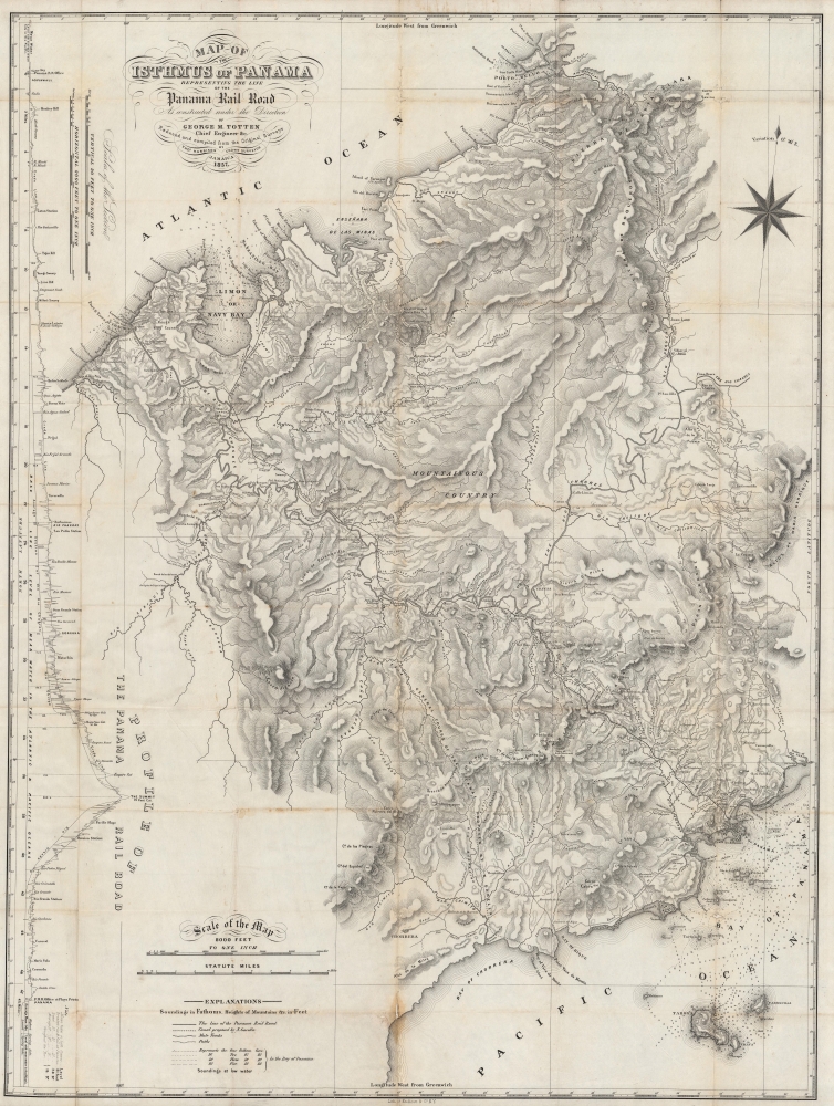
1857 Totten / Harrison Map of Panama: Railroad and Canal
Panama-totten-1857$600.00


Title
Map of the Isthmus of Panama representing the line of the Panama Rail Road as constructed under the direction of George M. Totten, chief engineer etc.
1857 (dated) 36 x 27.25 in (91.44 x 69.215 cm) 1 : 96000
1857 (dated) 36 x 27.25 in (91.44 x 69.215 cm) 1 : 96000
Description
A fascinating 1857 folding map of Panama, highlighting the course of the recently-completed Panama Railroad and the proposed Panama Canal. It was produced by George Totten, the railroad's chief engineer, relying on earlier surveys by Thomas Harrison.
The proposed canal was laid down by Napoléon Garella, a French engineer sent to survey a potential canal route. Garella's scheme failed to attract funding and was abandoned. It is notable for lying considerably to the west of the ultimate canal course from Colón to Panama City.
A plan in the late 1840s gained more traction, thanks in part to fortuitous timing, coinciding with the California Gold Rush (1848 - 1850). Even prior to the Gold Rush, the growing presence of Europeans on the west coast of North America demanded an easier connections between the Atlantic and Pacific. American businessman William Henry Aspinwall and his partners founded the Pacific Mail Steamship Company in 1848 and immediately set about drumming up interest and capital for a railway in Panama under the auspices of the Panama Railroad Company. The project's chief engineer, George Totten, had to contend with incredible challenges, including swampy ground, dense forests, broiling heat, and tropical diseases.
The first task was to construct a city on Panama's Atlantic coast for unloading the necessary supplies and rolling stock for the railway. The city of Aspinwall (Colón) was founded on the island of Manzanillo, which was then connected to the mainland over a causeway built over pile-driven timbers. The initial portion of the railway was one of the most difficult, and 20 months of work resulted in just 8 miles of track at the cost of hundreds of workers' lives and staggering investment. At this point, the railway reached navigable waterways across the isthmus to Panama City. Forty-niners eager to get to California were happy to pay handsomely for the 8-mile ride, providing necessary capital for completion of the railway. Still, the project was not finished until January 1855. It necessitated the construction of more than 150 bridges and culverts, as well as constant infusions of gravel to shore up the roadbed, and a massive excavation at the Culebra Cut. In all, the project cost $8 million and the lives of as many as 10,000 workers, hailing from as far away as China. It preceded the more celebrated 'Transcontinental Railroad' in the U.S. by five years and greatly facilitated travel between the Atlantic and Pacific.
Some fifty years later, the Panama Canal project was undertaken, following the course of the railway. Rather than replacing the railroad, the two avenues of transportation became symbiotic, to the extent that the railway was later renamed the Panama Canal Railway. After becoming unprofitable and falling into disrepair in the late 20th century, control was turned over to the Panamanian government. In the early 21st century, a group of private entities were given control of the railway and undertook long-overdue renovations, allowing it to continue its role as an important freight and passenger service.
A Closer Look
The narrowest part of the isthmus is displayed in remarkable detail, with waterways, elevation, settlements, the course of the railroad, and the route of a proposed canal indicated. Occasional notes describe terrain, such as 'swamp,' 'beautiful,' and 'undulating savanna.' On navigable waters, soundings, hazards, islands, and coastal features are noted. A profile of the terrain across the isthmus is provided at left. Much of the land here illustrated was flooded with the 1913 damming of the Charges River, creating Gatún Lake and facilitating the Panama Canal.The proposed canal was laid down by Napoléon Garella, a French engineer sent to survey a potential canal route. Garella's scheme failed to attract funding and was abandoned. It is notable for lying considerably to the west of the ultimate canal course from Colón to Panama City.
The Panama Railroad
Less well-known than the more famous canal, the Panama Railroad was the first major trans-isthmus link and an engineering marvel in its own right. The idea for a trans-continental channel between the Pacific and Atlantic can be traced to the Spanish colonial period, when roads and trails crossed the isthmus. Must such roads fell into disrepair during the Napoleonic Wars and Latin American wars of Independence. Here thye are noted here as 'now only practicable during the dry season.' Alexander von Humboldt, Simon Bolívar, and Andrew Jackson all proposed building a more durable route across the isthmus, and plans began in earnest in the 1830s for a railroad or canal. However, logistical and financial challenges ruined these early efforts before they could get off the ground.A plan in the late 1840s gained more traction, thanks in part to fortuitous timing, coinciding with the California Gold Rush (1848 - 1850). Even prior to the Gold Rush, the growing presence of Europeans on the west coast of North America demanded an easier connections between the Atlantic and Pacific. American businessman William Henry Aspinwall and his partners founded the Pacific Mail Steamship Company in 1848 and immediately set about drumming up interest and capital for a railway in Panama under the auspices of the Panama Railroad Company. The project's chief engineer, George Totten, had to contend with incredible challenges, including swampy ground, dense forests, broiling heat, and tropical diseases.
The first task was to construct a city on Panama's Atlantic coast for unloading the necessary supplies and rolling stock for the railway. The city of Aspinwall (Colón) was founded on the island of Manzanillo, which was then connected to the mainland over a causeway built over pile-driven timbers. The initial portion of the railway was one of the most difficult, and 20 months of work resulted in just 8 miles of track at the cost of hundreds of workers' lives and staggering investment. At this point, the railway reached navigable waterways across the isthmus to Panama City. Forty-niners eager to get to California were happy to pay handsomely for the 8-mile ride, providing necessary capital for completion of the railway. Still, the project was not finished until January 1855. It necessitated the construction of more than 150 bridges and culverts, as well as constant infusions of gravel to shore up the roadbed, and a massive excavation at the Culebra Cut. In all, the project cost $8 million and the lives of as many as 10,000 workers, hailing from as far away as China. It preceded the more celebrated 'Transcontinental Railroad' in the U.S. by five years and greatly facilitated travel between the Atlantic and Pacific.
Some fifty years later, the Panama Canal project was undertaken, following the course of the railway. Rather than replacing the railroad, the two avenues of transportation became symbiotic, to the extent that the railway was later renamed the Panama Canal Railway. After becoming unprofitable and falling into disrepair in the late 20th century, control was turned over to the Panamanian government. In the early 21st century, a group of private entities were given control of the railway and undertook long-overdue renovations, allowing it to continue its role as an important freight and passenger service.
Publication History and Census
This map was prepared by George Totten, the chief engineer of the Panama Railroad who built several other railways in Central and South America. Totten relied on earlier surveys undertaken by Thomas Harrison, a British surveyor based in Jamaica. It was printed in New York by Endicott. This map is held by 11 institutions worldwide and is scarce to the market, especially in such good condition.CartographerS
Thomas Harrison (c. 1823 - 1894) was a British surveyor active in the Caribbean and Central America, who most notably served as the first Government Surveyor of Jamaica. He had apprenticed under Edward McGeachy (d. c. 1851), whom he succeeded as Surveyor of the county of Surrey on Jamaica. Harrison built upon the work of McGeachy and fulfilled the latter's dream of conducting a detailed scientific survey of the entire island. More by this mapmaker...
Endicott and Company (fl. c. 1828 - 1891) was a New York based family run lithography firm that flourished throughout the 19th century. The firm was founded by George and William Endicott, brothers who were born in Canton, Massachusetts. George Endicott (June 14, 1802 - 1848) trained as a lithographer under Pendleton Lithography from January 1826. He later worked as superintendent of Senefelder Company until the summer of 1828. Afterwards, in 1830, he relocated to Baltimore and partnered with Moses Swett. Endicott and Swett relocated to New York City in December 1831. They remained partners until July 1834 when the relationship dissolved. George set up shop on his own account at 359 Broadway. William Endicott (1815 - 1851), George's younger brother of 14 years, joined the firm in 1840 and was made a partner in 1845, after which the name of the firm was changed to G. and W. Endicott. George Endicott died shortly afterward, in 1848, but William continued operating the firm as William Endicott and Co. until his own 1851 death at just 35 years old. The firm was carried on by his widow Sara Munroe Endicott until it was taken over by her son, Francis Endicott, who ran the firm from 1852 to 1886. George Endicott, Jr. subsequently ran the firm from 1887 to 1891. Peters, in his important work on American lithography America on Stone writes 'it is hard to summarize the Endicotts. They did everything and did it well . . . [they] worked with and for Currier and Ives, yet in spite of all that much of their work lacks real individuality.' The Endicott firm was responsible for many 19th century views and plans of New York City and state as well as plans of Sacramento, California, and the Midwest. Learn More...
Condition
Good. Wear, discoloration, and some loss along the fold lines, repaired on the verso, including areas of infill.
References
OCLC 10275162, 84227805, 494863009.