1960 Carter Pictorial Map of Panama and the Panama Canal Zone
PanamaCanalZone-carter-1960$250.00

Title
Pictorial Map of the Republic of Panama and the Canal Zone.
1960 (dated) 15.75 x 23.5 in (40.005 x 59.69 cm) 1 : 1250000
1960 (dated) 15.75 x 23.5 in (40.005 x 59.69 cm) 1 : 1250000
Description
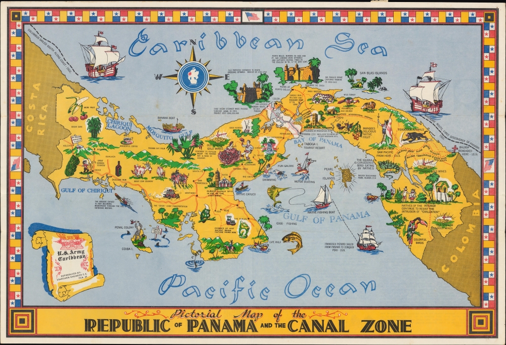
A 1960 pictorial mailer map of Panama and the Panama Canal Zone drawn by B. J. Carter and distributed to servicemembers of the U.S. Army Caribbean, tasked with defending the canal zone.
The first proper attempt to build an interoceanic canal was the vision of the French diplomat Ferdinand de Lesseps. Lesseps had successfully excavated the Suez Canal and saw the construction of the Panama Canal as a grander, more lucrative next project. He incorporated the Compagnie Universelle du Canal Interoceanique on March 3, 1881, which purchased a controlling stake in the existing railroad. Unprepared for the jungle climate, all progress was soon mired by disease, poor planning, political posturing, fraud, and bankruptcy. The Compagnie Universelle du Canal Interoceanique was dissolved by a French bankruptcy court on February 4, 1889, a development that became a major political scandal, largely because many French legislators had been investors in the company.
Five years later, in 1894, the company's assets were reorganized under new investors as Compagnie Nouvelle du Canal de Panama. This organization immediately began new plans to resume excavations, including producing detailed new maps of the project. Ultimately, the French lost control of the canal project to the United States. In 1903, the Hay-Bunau-Varilla Treaty between Panama and the United States granted the U.S. canal-building rights and the sole right to operate and control the Canal Zone. The Compagnie Nouvelle du Canal de Panama sold its holdings (including the railroad) to the United States in 1904, supplanting an earlier failed American venture to build a canal in Nicaragua. The Panama Canal officially opened under U.S. management ten years later in 1914.
Although the canal was an engineering marvel several decades in the making, its opening was marred by the outbreak of the First World War. The high death rate of workers (most of whom were from the Caribbean), especially from yellow fever and malaria, also casts a pall over the success of its construction. Still, the canal drastically cut travel times between the Pacific and Atlantic, was a major asset to the Allies during World War II (1939 - 1945), and has helped Panama become the wealthiest country in Central America per capita.
The Canal Zone remained a U.S. territory until the 1977 Torrijos-Carter Treaty began a gradual return of the territory to Panamanian sovereignty and management, a process completed in 2000. After coming under full Panamanian control, a third and wider lane of locks was constructed and opened in 2016, allowing larger 'Panamax' container ships to transit the canal.
A Closer Look
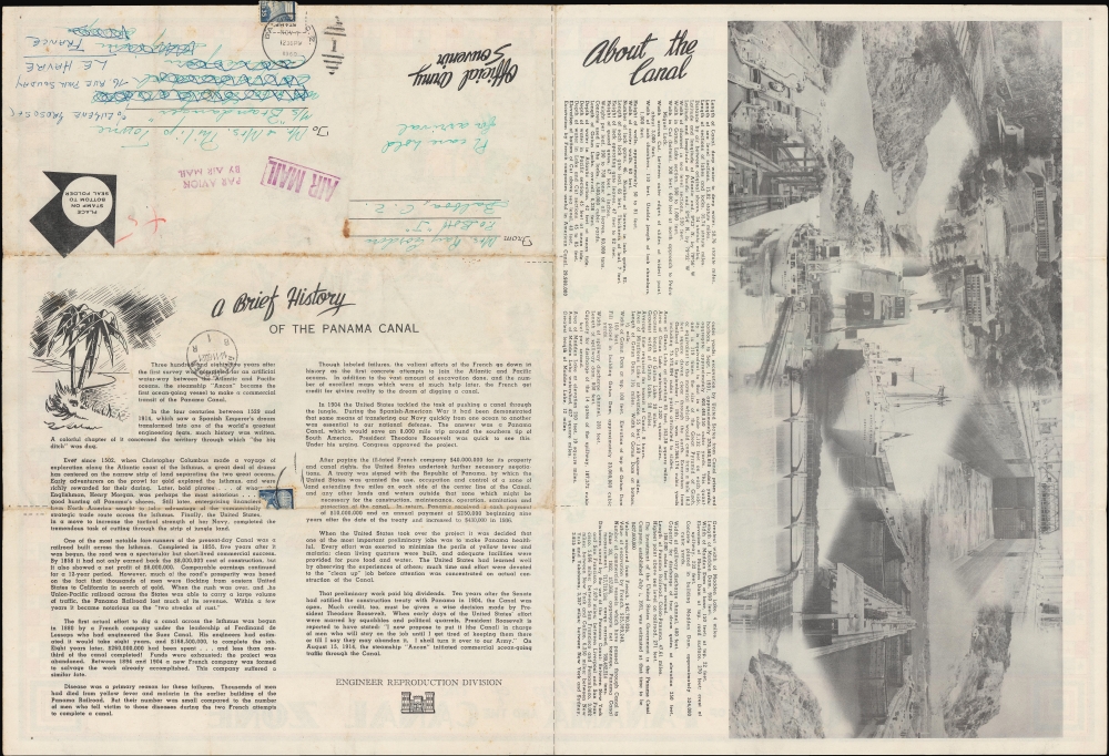
Pictorial vignettes highlight historical events and sites, structures (such as forts and churches), aspects of Panamanian culture, and wildlife. Natural wonders are depicted, including Chorrera Falls and Panama's diverse wildlife. Dotted lines trace Balboa's treks across the isthmus along with the Camino Real, the military and treasure road used during the 17th century. Red lines outline the route of highways, including the completed and incomplete sections of the Pan-American Highway (here as 'Proposed International Highway'). The Canal Zone appears as a section of white dividing Panama in two. The verso contains information and images about the canal, as well as a space for postage stamps and addresses that would be on the outside of the map when folded.The Pan-American Highway
Originally conceived as a railway in the late 19th century, the Pan-American Highway is a network of roads measuring about 29,800 miles in length that links the mainland nations of the Americas in a single interconnected highway system stretching from Alaska to Buenos Aires, Argentina and Santiago, Chile, except for a 54-mile break at the Darien Gap on the border of Panama and Colombia. By improving existing highways and constructing new ones, the long-discussed project was gradually brought to fruition over several decades in the early-mid 20th century, with periodic advances when efforts could be organized at an international level. One such period was the presidency of Franklin D. Roosevelt, who advocated extending the road south from Mexico, which it already traversed by the mid-1940s. Roosevelt's support for the highway's construction through Latin America was a manifestation of his 'Good Neighbor Policy.'Panama Canal
The potential for bridging the narrow isthmus of Panama to link the Pacific and Atlantic Oceans had been conceived long before the completion of the canal, but the hurdles standing in the way of such a connection were formidable, including dense jungle, mountains, and tropical diseases. The first major link across the isthmus was the Panama Railroad, built by American investors in the early 1850s to facilitate the California Gold Rush.The first proper attempt to build an interoceanic canal was the vision of the French diplomat Ferdinand de Lesseps. Lesseps had successfully excavated the Suez Canal and saw the construction of the Panama Canal as a grander, more lucrative next project. He incorporated the Compagnie Universelle du Canal Interoceanique on March 3, 1881, which purchased a controlling stake in the existing railroad. Unprepared for the jungle climate, all progress was soon mired by disease, poor planning, political posturing, fraud, and bankruptcy. The Compagnie Universelle du Canal Interoceanique was dissolved by a French bankruptcy court on February 4, 1889, a development that became a major political scandal, largely because many French legislators had been investors in the company.
Five years later, in 1894, the company's assets were reorganized under new investors as Compagnie Nouvelle du Canal de Panama. This organization immediately began new plans to resume excavations, including producing detailed new maps of the project. Ultimately, the French lost control of the canal project to the United States. In 1903, the Hay-Bunau-Varilla Treaty between Panama and the United States granted the U.S. canal-building rights and the sole right to operate and control the Canal Zone. The Compagnie Nouvelle du Canal de Panama sold its holdings (including the railroad) to the United States in 1904, supplanting an earlier failed American venture to build a canal in Nicaragua. The Panama Canal officially opened under U.S. management ten years later in 1914.
Although the canal was an engineering marvel several decades in the making, its opening was marred by the outbreak of the First World War. The high death rate of workers (most of whom were from the Caribbean), especially from yellow fever and malaria, also casts a pall over the success of its construction. Still, the canal drastically cut travel times between the Pacific and Atlantic, was a major asset to the Allies during World War II (1939 - 1945), and has helped Panama become the wealthiest country in Central America per capita.
The Canal Zone remained a U.S. territory until the 1977 Torrijos-Carter Treaty began a gradual return of the territory to Panamanian sovereignty and management, a process completed in 2000. After coming under full Panamanian control, a third and wider lane of locks was constructed and opened in 2016, allowing larger 'Panamax' container ships to transit the canal.
The 193rd Infantry Brigade and Panama
Following the botched 1961 Bay of Pigs Invasion in Cuba and rumors of Soviet aid to the Cubans, Secretary of Defense Robert McNamara decided to strengthen the U.S. Army presence in the Panama Canal Zone. The 193rd Infantry Brigade, activated on August 8, 1962, replaced the battle group in the Canal Zone. The 193rd Infantry Brigade remained in Panama, participated in Operation Just Cause after the abortive 1989 Panamanian elections, and remained in Panama until it was deactivated on October 14, 1994, as part of the Panama Canal Treaty of 1977, mandating the complete withdrawal of U.S. troops by December 1999.Publication History and Census
This map was published in 1960 by the Engineer Reproduction Division of the U.S. Army Caribbean (USARCARIB), previously known as the Panama Canal Department. We note an earlier edition of the present map, published c. 1950 by the Engineer Reproduction Plant of USARCARIB, a predecessor to the Engineer Reproduction Division, and was drawn by B. J. Carter. There appear to have been multiple issues of this map throughout the 1950s and 1960s, with slight variations such as the image inside the compass rose, the text in the title cartouche, and the arrangement of content and images on the verso. Due to these variations, we have not been able to determine a solid census for the present map, though the University of Kansas does catalog an example dated 1960 as here.Condition
Good. Light wear along original folds. Text on verso. Postage stamp still attached. Pinholes in corners.
References
OCLC 341982081.