This item has been sold, but you can get on the Waitlist to be notified if another example becomes available, or purchase a digital scan.
1915 Amos Map or Panoramic View of the Panama-Pacific Exposition, San Francisco
PanamaPacificPanorama-amos-1915$125.00

Title
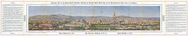
Panoramic View of the Panama-Pacific Exposition, Show the Beautiful Island Dotted Bay and the World-Renowned Golden Gate in the Distance.
1915 (dated) 8.25 x 45 in (20.955 x 114.3 cm)
1915 (dated) 8.25 x 45 in (20.955 x 114.3 cm)
Description
This is a 1916 B. E. Amos map or panoramic view of the Panama-Pacific Exposition in San Francisco, California. The map depicts the exposition grounds from the Inside Inn, a hotel on the Exposition grounds to the Palace of Machinery and from the Exposition grounds to San Francisco Bay and Alcatraz Island, home to the infamous prison. Twenty-four different sites are identified numerically throughout the panorama. Apart from Alcatraz Island (location twenty-four), each of the identified sites play a role in the exposition, such as the Palace of Transportation and the Column of Progress. Eleven locations around the region are labeled along the border on both the top and bottom of the view. On the verso, practical information about the exposition, including special events, and information about San Francisco is present. Six photographs of locations within the exposition and around San Francisco also are included.
The Panama-Pacific Exposition was a World's Fair held in San Francisco from February 20 to December 4, 1915. Situated along the northern shore of San Francisco Bay, between Presidio and Fort Mason, an area known today as the Marina District, the fair ostensibly celebrated the completion of the Panama Canal. However, many in the city viewed it as an opportunity to showcase the city's recovery following the 1906 earthquake.
This map was produced by B. E. Amos and printed and engraved by San Francisco Photo-Engraving Company in 1915.
Condition
Very good. Minor verso repairs to fold separations. Text on verso.
References
OCLC 894273055.