This item has been sold, but you can get on the Waitlist to be notified if another example becomes available, or purchase a digital scan.
1871 Le Monde Illustrated Bird's Eye View Map of Germany and Vicinity
PanoramiqueTheatre-monde-1871$100.00

Title
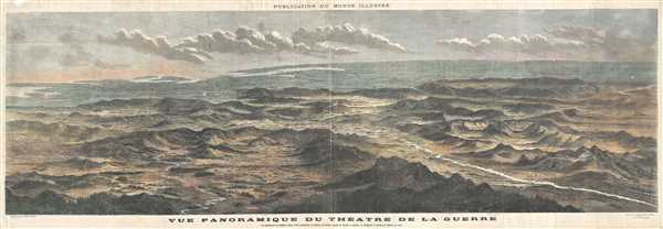
Vue Panoramique du Theatre de la Guerre Le spectateur se suppose place a 64 kilometers au-dessus de Paris, ayant la Suisse a droite, la Belgique a gauche, et Berlin en face.
1870 (dated) 13.5 x 41 in (34.29 x 104.14 cm)
1870 (dated) 13.5 x 41 in (34.29 x 104.14 cm)
Description
This is a beautiful bird’s eye view map of Germany, Belgium and Switzerland appearing in the 1870 issue of Monde Illustre. This magnificent panoramic view illustrates the Theater of War and depicts the region as seen from Paris and spans from Belgium on the left across Germany to Switzerland on the right. Important towns and cities are identified with Nancy, Saint Die and Mulhouse in the foreground and St. Petersburg near the horizon. These include Munster, Cologne, Berlin, Prague and Munich among several others.
The Franco-Prussian War or the Franco-German War, fought in 1870-1871 between the North German Confederation (led by the Kingdom of Prussia) and the French Empire was a battle that was influenced by Prussia’s ambition for German Unification. In the hopes French attack would encourage the southern German states to join the Prussian dominated North German Confederate states, the Prussian Chancellor Otto van Bismarck planned to provoke the French. The war ultimately led to a German victory and resulted in the formation of the German Empire and the fall of the French Empire. Germany also annexed Alsace-Lorraine.
The view features beautiful views of hills, mountains, rivers and roads. This view was drawn by A. Deroy and engraved by A. Daudenarde and appears in the 1870 edition of Monde Illustre.
Source
Le Monde Illustre, 1870.
Condition
Very good. Minor wear along fold lines. Some edge wear and minor verso repairs. Minor spotting.