1908 Montenegro Map of the State of Pará, Amazonia, Brazil
ParaBrazil-montenegro-1908$800.00


Title
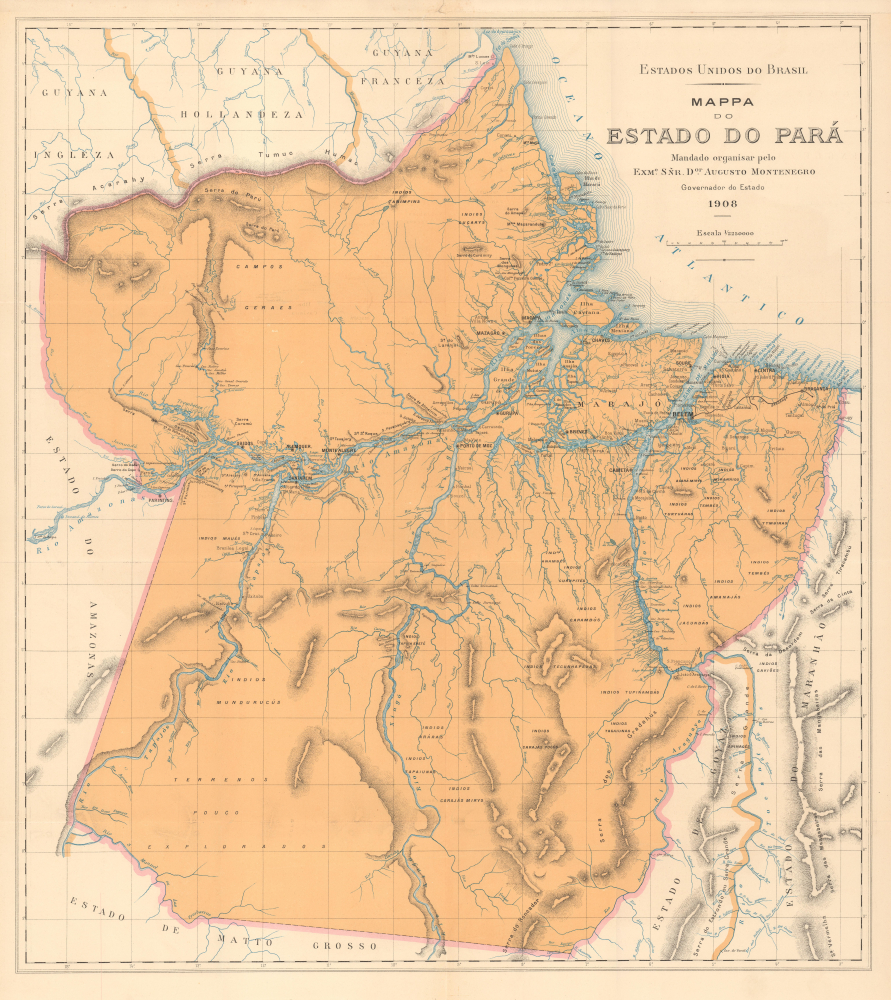
Mappa do Estado do Pará.
1908 (dated) 30.25 x 27 in (76.835 x 68.58 cm) 1 : 2250000
1908 (dated) 30.25 x 27 in (76.835 x 68.58 cm) 1 : 2250000
Description
This is a large-format 1908 map of the State of Pará, Brazil, produced for the book Album do estado do Pará. The map and book were supported by Governor Augusto Montenegro, a modernizer who sought foreign investment in the state, especially in its burgeoning rubber industry.
Other modernizing ventures were also launched, including the aforementioned agricultural colony near Bragança, named after Benjamin Constant Botelho de Magalhães (1836 - 1891), a Brazilian military officer and arguably the founder of the Brazilian republic who was also a champion of French positivist thinking. As a result of these various modernizing projects and industries, the population of the state of Pará more than doubled between 1900 and 1920, while some towns along the Amazon like Óbidos sprang up in a matter of months.
These developments were encouraged by Governor Augusto Montenegro (in office 1901 - 1909), a modernizer who commissioned this map and the book in which it appeared. The fact that the book was published in Paris is no coincidence - Montenegro no doubt would have been looking for Europeans to invest in and move to his state, and the French were the most interested party in Brazil's rubber industry at the time.
A Closer Look
This map covers the large state of Pará in northern Brazil, through which the Amazon River flows and empties into the Atlantic Ocean. The Amazon and its many tributaries are diligently noted here, as are other river systems, with waterfalls (cachoeira, abbreviated cac.) marked. Cities and towns, mountains, roads, islands, a railway (linking Belém to Bragança and a nearby agricultural colony), and neighboring states are also indicated. Sparsely populated areas further from the Amazon record indigenous groups or use vague descriptors like 'campos geraes' or 'terrenos pouco explorados.'Brazil's Rubber Boom
This map was produced at the height of the Amazon rubber boom (or cycle) in the late 19th and early 20th centuries, when large numbers of European immigrants were arriving to work plantations along the Amazon. Belém, at the mouth of the Amazon, saw an influx of new arrivals. Even Óbidos in the western part of the state saw considerable development, including the installation of electricity and running water, becoming the first interior city along the Amazon to have such amenities.Other modernizing ventures were also launched, including the aforementioned agricultural colony near Bragança, named after Benjamin Constant Botelho de Magalhães (1836 - 1891), a Brazilian military officer and arguably the founder of the Brazilian republic who was also a champion of French positivist thinking. As a result of these various modernizing projects and industries, the population of the state of Pará more than doubled between 1900 and 1920, while some towns along the Amazon like Óbidos sprang up in a matter of months.
These developments were encouraged by Governor Augusto Montenegro (in office 1901 - 1909), a modernizer who commissioned this map and the book in which it appeared. The fact that the book was published in Paris is no coincidence - Montenegro no doubt would have been looking for Europeans to invest in and move to his state, and the French were the most interested party in Brazil's rubber industry at the time.
Publication History and Census
This map was produced in 1908 and appeared in the book Album do estado do Pará, commissioned by Governor Augusto Montenegro, written by Ernesto Mattoso, and published by Imprimerie Chaponet (Jean Cussac) in Paris. The map is not independently cataloged in the OCLC, though the book is well-represented in institutional collections. Scarce to the market.Source
Mattoso, E., Album do estado do Pará, (Paris: Impr. Chaponet / J. Cussac) 1908.
Condition
Very good. Minor repair upper margin at center. Slight wear on old fold lines.