This item has been sold, but you can get on the Waitlist to be notified if another example becomes available, or purchase a digital scan.
1827 Berthe / Rengger map of Paraguay and Uruguay
Paraguay-rengger-1827$600.00

Title
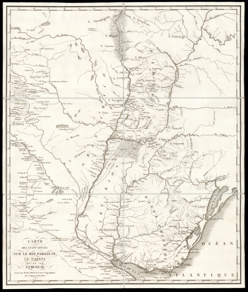
Carte des Etats Situés Sur Le Rio Paraguay, le Parana et L'Uruguay.
1827 (undated) 20.75 x 17.5 in (52.705 x 44.45 cm) 1 : 3600000
1827 (undated) 20.75 x 17.5 in (52.705 x 44.45 cm) 1 : 3600000
Description
This is a scarce, folding map of Paraguay, Uruguay, and their neighboring regions, printed by Berthe to accompany J. R. Rengger's 1827 history of Paraguay and its first dictator. This region at the heart of South America was, in the 19th century, one of the least-known and most remote parts of the inhabited world. The map is derived from the 1809 work of Spanish border commissioner and military engineer Félix de Azara - Rengger was no cartographer, and Azara's work remained the best available. The map has been updated to reflect Rengger's reports, however, and as such it is the best cartographic depiction of Paraguay and its vicinity during the government of José Gaspar Rodríguez de Francia (lasting from 1811 until his 1840 death).
Paraguay executed its citizens and unpermitted foreigners who attempted to leave the country, but it didn't need to do so with respect to its northern and eastern borders. The desolate northern border with Brazil, and the uncharted wilderness to the east could be expected to do the job without military assistance. Any successful attempt to flee required the use of either the Paraguay or the Paraná Rivers, which formed the country's most definite borders to the west and south. Consequently, Rengger's map includes, all along the Paraguayan banks of both of those rivers, a series of security posts - Guardia - populating the border with sentinels from the Paraná north beyond Concepión (Villa Real). The Rio Aquidabanigny forms the limit, sporting three sentinel posts, as well as Fort San Carlos. Extending the southern frontier from the southern bank of the Paraná is the fort of San Miguel, according to Rengger, a garrison of some four hundred cavalry established in 1822 to patrol the area between that river and the Uruguay River, both as an advance post against Argentina, but also 'to prevent the people of Corrientes from preparing the herb of Paraguay in the missions, and to keep up communications with Brazil'. None of these guard garrisons or forts are present on the Azara map, and all reflect the political changes of the Francia regime, as observed by Rengger in his 1827 report.
A Closer Look
The map's overall detail, particularly concerning areas surrounding Paraguay, is drawn from Felix de Azara's 1809 'Carte generale du Paraguay et de la province de Buenos-Ayres'. This includes the array of Argentinian forts throughout the Chaco to the west of the Parana (not relating to defense from Paraguay, but rather from attacks by Indigenous nations). These populations are noted throughout, with the Guarani prominent in Paraguay. The vagueness of national boundaries is not an error, and is unsurprising given the level of disagreement regarding them, despite the efforts of Azara.The Borders Are Vague But Closed
Rengger and his fellow naturalist Marcel Longchamp came to Paraguay in 1818 to study the country's natural history. Doing so in the post-revolutionary country proved difficult. Paraguay was then led by 'El Supremo,' the dictator José Gaspar Rodríguez de Francia (1766 - 1840). Francia was intent on building Paraguay into a nation no longer tied to colonial economic elites. Consequently, among Paraguay's indigenous Guarani, he was popular. In 1820, two years into Rengger's visit, Francia was declared Supremo Dictator Perpetuo. Under El Supremo, Paraguay became a police state, with internal espionage effectively ending free speech. Francia ordered the closing of Paraguay's borders, largely to break the power of exporters of yerba mate and tobacco, which members of the former ruling class controlled. This resulted in Rengger and Longchamp's visit to the country being extended, arbitrarily and indefinitely. The naturalists required special permits for travel even within the country. The issuance of their export visa in 1825 amounted to an expulsion. Following his hasty repatriation, Rengger delayed the publication of his natural history in favor of publishing an 1827 political exposé of the Francia regime.Paraguay executed its citizens and unpermitted foreigners who attempted to leave the country, but it didn't need to do so with respect to its northern and eastern borders. The desolate northern border with Brazil, and the uncharted wilderness to the east could be expected to do the job without military assistance. Any successful attempt to flee required the use of either the Paraguay or the Paraná Rivers, which formed the country's most definite borders to the west and south. Consequently, Rengger's map includes, all along the Paraguayan banks of both of those rivers, a series of security posts - Guardia - populating the border with sentinels from the Paraná north beyond Concepión (Villa Real). The Rio Aquidabanigny forms the limit, sporting three sentinel posts, as well as Fort San Carlos. Extending the southern frontier from the southern bank of the Paraná is the fort of San Miguel, according to Rengger, a garrison of some four hundred cavalry established in 1822 to patrol the area between that river and the Uruguay River, both as an advance post against Argentina, but also 'to prevent the people of Corrientes from preparing the herb of Paraguay in the missions, and to keep up communications with Brazil'. None of these guard garrisons or forts are present on the Azara map, and all reflect the political changes of the Francia regime, as observed by Rengger in his 1827 report.
Publication History and Census
This map was engraved and printed by Berthe in Paris for inclusion in Rengger and Longchamp's 1827 Essai historique sur la révolution du Paraguay, et le gouvernement dictatorial du Docteur Francia. Only a single example of the separate map is recorded in OCLC, although the book is well represented in institutional collections. Rare on the market.CartographerS
Johann Rudolph Rengger (January 13, 1795 - October 9, 1832) was a Swiss naturalist and doctor. He is best known for his books pertaining to his exploration of Paraguay. Having received an education as a doctor and natural scientist in Switzerland, he spent the years between 1818 and 1826 in Paraguay, his intention having been to undertake a research trip with colleague Marcel Longchamp, in order to document the natural history of the country. The two immediately became entangled in the politics of the region. They first endured a delay of eight months in Corrientes due to the river blockade by the United Provinces of the Rio de la Plata under José Gervasio Artigas. After finally reaching Paraguay - then ruled by 'El Supremo,' the dictator José Gaspar Rodríguez de Francia - they found their every move supervised by government officials. While Rengger avoided arrest as a spy (as occurred with French botanist Aimé Bonpland) the two were not allowed to cross the border, and required special permits for every excursion they made. In addition, Rengger and Longchamp were virtally isolated from the rest of the world, as indeed was all of de Francia's Paraguay: 'El Supremo' blocked most of Rengger's mail. When the two eventually obtained an exit permit in 1825, they were allowed only a few hours to prepare for the journey, and had to leave without most of their collections. This ejection from Paraguay finally saw the pair's return to Europe. In Paris, Rengger began to compile his research, only to find that his European audience was little interested in Paraguay's flora and fauna, but powerfully curious about the country's dictator. Therefore Rengger first published, instead, his historical essay on the Paraguayan revolution and the dictatorship of Francia: the book was printed in 1827. Excerpts published in the Stuttgarter Morgenblatt reached the dictator, and goaded him to rebut the work. Only after this political foray did Rengger complete his natural history. Further descriptions of his journey were cut short by Rengger falling ill with pneumonia, an illness which would ultimately take his life. More by this mapmaker...
Azara, Félix de (May 18, 1742 - October 20, 1821) was a Spanish military officer, naturalist, and engineer. He joined the Army, and received training as an engineer in a Spanish military academy. His thirteen year career in the Army would see him promoted to Brigadier General. He spent twenty years in the Rio de la Plata region of South America as a delegate under the treaty of San Ildefonso, during which period he undertook to create an accurate map of the region. On the surveys, he also recorded the fauna the region, in particular cataloguing nearly four hundred species of bird. On his return to Europe in 1801 he wrote and published in Paris his Voyage dans l'Amerique meridionale depuis 1781 jusqu'en 1801 (1809) which contained his observations on the region's geography, natural features, and indigenous groups. His work was praised for thoroughness and accuracy, and was well regarded by Darwin. He died of pneumonia on October 20, 1821. Learn More...
L. H. Berthe (fl. c. 1777 - 1830) was a French engraver active in Paris in the early to mid-19th century. Little is known of Berthe. He seems to have been active as early as 1777 and as late as 1830. He maintained offices at Rue St. Jacques , No. 66. Learn More...
Condition
Excellent. Dissected and mounted on linen as issued, for folding. Original slipcase with marbled papers and gold-embossed title and spine.
References
OCLC 166034808.