This item has been sold, but you can get on the Waitlist to be notified if another example becomes available, or purchase a digital scan.
1730 Seutter Map of Paraguay
Paraguay-seutter-1730$275.00

Title
Paraquariae Provinciae Soc. Iesu com Adjacentibus Novissima Descriptio Post iteratas peregrinationes, et plures observationes Patrum Missionariorum eiusdem Soc. tom huius Provinciae cum et Peruvanae accuratissime delin. a Matthaeo Seuttero, S.C.M.G. August.
1730 (undated) 22.5 x 19.25 in (57.15 x 48.895 cm) 1 : 5100000
1730 (undated) 22.5 x 19.25 in (57.15 x 48.895 cm) 1 : 5100000
Description
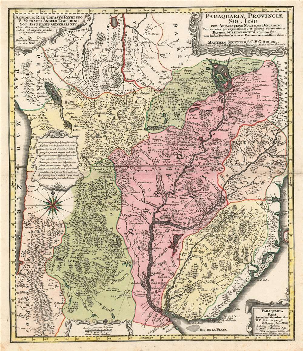
This is Matthias Seutter's 1730 map of Paraguay, showing specifically the Jesuit province of Paraguay and the surrounding regions including present-day Uruguay, and parts of Argentina and Brazil. This map, commonly given a date of 1730, is a faithful copy of a 1722 map of the same area produced by Juan Francisco D'Avila, which substantially improved from earlier maps of the region and provided what was the most complete map of the Rio de la Plata watershed available at the time. Furlong, in his Cartografia jesuttica del Rio de la Plata hailed the D'Avila map as 'without doubt the most complete and most comprehensive map undertaken by the Jesuits up to the middle of the eighteenth century' (Buenos Aires, 1936, p. 44). This map does not exhibit any of the added missionary tracks that appear on Antonio Marchoni's corrected 1732 iteration of the map, supporting a 1730 date. The map shows the full length of the Rio de la Plata from its source at the mythical Lake Xarayes (see below) to its mouth, at Buenos Aires and Montevideo. The map embraces central South America, and includes the Pacific coast from Peru to Coqimbo in Chile. Lake Titicaca (Chiquito, on the map) is shown, as is the famous Cerro Potosi, location of the Spanish Colonial silver mint - source of the massive wealth of silver drawn from South America by Spain via slave labor throughout the sixteenth and seventeenth centuries. Throughout the map are shown Jesuit missions - both active, and those destroyed by the indigenous population. Cities with Jesuit colleges are shown as well. As is not atypical for Jesuit maps, the locations of martyrdoms are also shown.
Laguna de Xarayes
The mythical Laguna de Xarayes is illustrated here as the northern terminus, or source, of the Paraguay River. The Xarayes, a corruption of 'Xaraies' meaning 'Masters of the River', were an indigenous people occupying what are today parts of Brazil's Mato Grosso and the Pantanal. When Spanish and Portuguese explorers first navigated up the Paraguay River, as always in search of El Dorado, they encountered the vast Pantanal flood plain at the height of its annual inundation. Understandably misinterpreting the flood plain as a gigantic inland sea, they named it after the local inhabitants, the Xaraies. The Laguna de los Xarayes almost immediately began to appear on early maps of the region and, at the same time, to take on a legendary quality. Later missionaries and chroniclers, particularly Díaz de Guzman, imagined an island in this lake and curiously identified it as an 'Island of Paradise,'...an island [of the Paraguay River] more than ten leagues [56 km] long, two or three [11-16 km] wide. A very mild land rich in a thousand types of wild fruit, among them grapes, pears and olives: the Indians created plantations throughout, and throughout the year sow and reap with no difference in winter or summer, ... the Indians of that island are of good will and are friends to the Spaniards; Orejón they call them, and they have their ears pierced with wheels of wood ... which occupy the entire hole. They live in round houses, not as a village, but each apart though keep up with each other in much peace and friendship. They called of old this island Land of Paradise for its abundance and wonderful qualities.Xarayes was, throughout the 18th century considered a possible gateway to the supposed riches of the Amazon interior.
Publication History and Census
Seutter's map was prepared for inclusion in his Grosser Atlas and was printed as early as 1730. (An OCLC notation for a 1709 issue would seem to be in error, as the progenitor of this map was not completed until 1722.) The map is well represented in institutional collections.Cartographer
Matthäus Seutter (1678 - 1757) was one of the most important and prolific German map publishers of the 18th century. Seutter was born the son of a goldsmith but apprenticed as a brewer. Apparently uninspired by the beer business, Seutter abandoned his apprenticeship and moved to Nuremberg where he apprenticed as an engraver under the tutelage of the prominent J. B. Homann. Sometime in the early 1700s Seutter left Homann to return to Augsburg, where he worked for the prominent art publisher Jeremiad Wolff (1663 - 1724), for whom he engraved maps and other prints. Sometime around 1717 he established his own independent cartographic publishing firm in Augsburg. Though he struggled in the early years of his independence, Seutter's engraving skill and commitment to diversified map production eventually attracted a substantial following. Most of Seutter's maps are heavily based upon, if not copies of, earlier work done by the Homann and De L'Isle firms. Nonetheless, by 1731/32 Seutter was one of the most prolific publishers of his time and was honored by the German Emperor Karl VI who gave him the title of Imperial Geographer, after which most subsequent maps included the Avec Privilege designation. Seutter continued to publish until his death, at the height of his career, in 1757. Seutter had two engraver sons, Georg Matthäus Seutter (1710 - 173?) and Albrecht Carl Seutter (1722 - 1762). Georg Matthäus quit the business and relocated to Woehrdt in 1729 (and probably died shortly thereafter), leaving the family inheritance to his wastrel brother Albrecht Carl Seutter, who did little to advance the firm until in own death in 1762. Following Albrecht's death, the firm was divided between the established Johann Michael Probst (1727 - 1776) firm and the emerging firm of Tobias Conrad Lotter. Lotter, Matthäus Seutter's son-in-law, was a master engraver and worked tirelessly on behalf of the Suetter firm. It is Lotter, who would eventually become one of the most prominent cartographers of his day, and his descendants, who are generally regarded as the true successors to Matthäus Seutter. (Ritter, M. Seutter, Probst and Lotter: An Eighteenth-Century Map Publishing House in Germany., "Imago Mundi", Vol. 53, (2001), pp. 130-135.) More by this mapmaker...
Source
Seutter, M. Grosser Atlas (Augsburg, 1730).
Condition
Excellent condition. Original wash color.
References
OCLC 159823477.