This item has been sold, but you can get on the Waitlist to be notified if another example becomes available, or purchase a digital scan.
1728 Stöcklein / D'Avila Map of Paraguay and the Surrounding Lands
Paraguay-stocklein-1728$2,250.00


Title
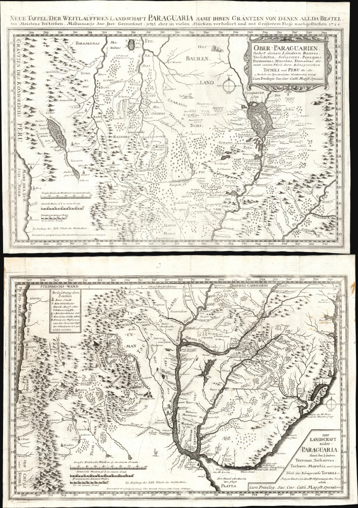
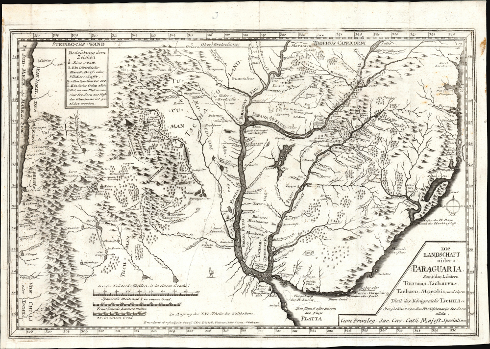
Ober-Paraguarien : Nebst denen Länderen Baures, Tschikiten, Schareyes, Paraguas, Toromonas, Moschos, Ytonamas etc. samt einem Theil dern Königreichen Tschili und Peru etc. etc/ Die Landschaft nider-Paraguaria : Samt den Ländern Tucuman, Tscharvas, Tschaco, Mocobis, und einem Theil des Königreichs Tschili ec.
1728 (dated) 28 x 20.75 in (71.12 x 52.705 cm) 1 : 4600000
1728 (dated) 28 x 20.75 in (71.12 x 52.705 cm) 1 : 4600000
Description
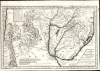
This is Joseph Stöcklein's 1728 map of central South America illustrating the Jesuit province of Paraguay and the surrounding regions, including present-day Uruguay, parts of Argentina, and Brazil. This two-sheet map is one of the earliest iterations of the 1722 map produced by Juan Francisco D'Avila, the most complete map of the Rio de la Plata watershed available at the time. The earliest printed D'Avila map was engraved by Giovanni Petroschi and published in Rome in 1726. In his Cartografia Jesuttica del Rio de la Plata, scholar Guillermo Furlong Cardiff hailed this unacquirable map as 'without doubt the most complete and most comprehensive map undertaken by the Jesuits up to the middle of the eighteenth century.' (Buenos Aires, 1936, p. 44). The present map, engraved in 1728 and published in the 1729 installment of Stöcklein's collection of Jesuit Relations, is the earliest acquirable version of Dávila's work.
At the time, the region was dominated by an expansive network of missionary outposts collectively known as the Jesuit Reductions (Reducciones Jesuiticas). Their mission was to convert, tax, govern, and develop the indigenous population, primarily the Tupi-Guarani. The Reductions were extremely successful on all fronts, developing a thriving inland economy largely distinct from the colonially administered coastal territories.
The success of the Reductions led to vast wealth. The Reductions individually and collectively leveed and equipped armies from their Guarani converts. Eventually, their prosperity and near independence drew the ire of colonial authorities in Europe, who increasingly sent troops into the Reductions. This spurred a series of armed conflicts, including the Guarani War of 1756, and led to a period known as 'The Suppression.'
The present example is one of the earliest derivatives of D'Avila's map. An example, probably the 1726 Petroschi, came to Stöcklein, who included it in his Jesuit Relation of 1729, preceding Seutter's 1730 iteration of the work.
A Closer Look
The map shows the full length of the Rio de la Plata from its source at the mythical Lake Xarayes (see below) to its mouth, at Buenos Aires and Montevideo. The map embraces central South America, including the Pacific coast from Peru to Coqimbo, Chile. Lake Titicaca (Chiquito) is shown, as is the famous Cerro Potosi, a literal mountain of silver and the location of the Spanish colonial silver mint. This was the source of the massive wealth of silver drawn from South America by Spain via slave labor throughout the 16th and 17th centuries. Throughout, Jesuit missions are noted - both those that remained active and those that were destroyed by indigenous peoples. Cities with Jesuit colleges and the locations of martyrdoms are also identified.Laguna de Xarayes
The mythical Laguna de Xarayes is illustrated here as the northern terminus, or source, of the Paraguay River. The Xarayes, a corruption of 'Xaraies' meaning 'Masters of the River,' were a native people occupying what are today parts of Brazil's Mato Grosso and the Pantanal. When Spanish and Portuguese explorers first navigated up the Paraguay River, as always in search of El Dorado, they encountered the vast Pantanal flood plain at the height of its annual inundation. Understandably misinterpreting the wetland as an inland sea, the explorers named it after the local inhabitants, the Xaraies. The Laguna de los Xarayes promptly began to appear on maps and, at the same time, to take on a legendary quality. Later missionaries and chroniclers, particularly Díaz de Guzman, imagined an island in this lake and curiously identified it as an 'Island of Paradise,'...an island [of the Paraguay River] more than ten leagues [56 km] long, two or three [11-16 km] wide. A very mild land rich in a thousand types of wild fruit, among them grapes, pears, and olives: the Indians created plantations throughout, and throughout the year sow and reap with no difference in winter or summer,... the Indians of that island are of good will and are friends to the Spaniards; Orejón they call them, and they have their ears pierced with wheels of wood... which occupy the entire hole. They live in round houses, not as a village, but each apart though keep up with each other in much peace and friendship. They called of old this island 'Land of Paradise' for its abundance and wonderful qualities.
Jesuit Reductions and the Suppression
The underlying cartography took D'Avila more than 10 years to compile. He began work on this map around 1712 at the order of the Father Provincial. In a letter dated 1722, D'Avila discloses that the map was made so that the Superior General Michelangelo Tamburini (1648 - 1730) could better understand distances between the Jesuit establishments in order more effectively manage the transference of personnel.At the time, the region was dominated by an expansive network of missionary outposts collectively known as the Jesuit Reductions (Reducciones Jesuiticas). Their mission was to convert, tax, govern, and develop the indigenous population, primarily the Tupi-Guarani. The Reductions were extremely successful on all fronts, developing a thriving inland economy largely distinct from the colonially administered coastal territories.
The success of the Reductions led to vast wealth. The Reductions individually and collectively leveed and equipped armies from their Guarani converts. Eventually, their prosperity and near independence drew the ire of colonial authorities in Europe, who increasingly sent troops into the Reductions. This spurred a series of armed conflicts, including the Guarani War of 1756, and led to a period known as 'The Suppression.'
The present example is one of the earliest derivatives of D'Avila's map. An example, probably the 1726 Petroschi, came to Stöcklein, who included it in his Jesuit Relation of 1729, preceding Seutter's 1730 iteration of the work.
Publication History and Census
This map is the work of the Jesuit lay brother Juan Francisco D'Avila (1682 - 1733). The underlying cartography was completed in 1722, and the map was first published in Rome by Petroschi in 1726. This example, printed to two sheets in Stöcklein's Allerhand so lehr- als geist-reiche Brief, Schrifften und Reis-Beschreibungen welche von denen Missionariis der Gesellschafft Jesu aus beyden Indien in 1729, was executed by Vienna engraver Christoff Distell. We are aware of only one edition of the work. Examples of Stöcklein's book are well represented in institutional collection, but we see listings of only one example of each of these separate sheets in OCLC, and they are very scarce on the market.CartographerS
Joseph Stöcklein [Stoecklein] (July 30, 1676 – December 28, 1733) was a Jesuit priest, missionary, and scholar active in the late 17th and early 18th centuries. He was born in Oettingen, Germany and joined the Jesuit order in Vienna around 1700. He served as a priest in military encampments where he became popular as a preacher. Afterwards he became the head of the Jesuit library in Graz, Switzerland, a position he maintained for six years. During this tenure he began work on his opus, the Welt-Bott, a vast compilation of Jesuit missionary letters and narratives translated into vernacular German intended both to glorify the priesthood and share valuable information about the world. Today this work is exceedingly rare. More by this mapmaker...
Juan Francisco d'Avila (1682 - 1733) was a Spanish colonial missionary and Jesuit lay brother active in Paraguay and Argentina in the early 17th century. D'Avila was born in Buenos Aires. He spent 10 years between 1712 and 1722 mapping the Jesuit Reductions in the Rio de La Plata Basin. Little else has been recorded of his life. Learn More...
Source
Stöcklein, J., Allerhand so lehr- als geist-reiche Brief, Schrifften und Reis-Beschreibungen welche von denen Missionariis der Gesellschafft Jesu aus beyden Indien, (Augsburg) 1729.
Condition
Very good. Margins reinstated at insertion points with slight mended tears into border. Few areas of scuffing and marginal staining.
References
OCLC 633536194 (top sheet) 634133283 (bottom)