This item has been sold, but you can get on the Waitlist to be notified if another example becomes available, or purchase a digital scan.
1870 Manuscript Map of the War of the Triple Alliance
Paraguay-triplealliance-1870$4,000.00

Title
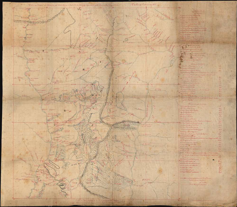
Esboco do Theatro das Operacoes das Cordilheiras do e do Norte do Paraguay organisado pela Commisao d'Engenheiros. V. do Rosario Febereiro de 1870
1870 (dated) 29 x 31 in (73.66 x 78.74 cm) 1 : 1000000
1870 (dated) 29 x 31 in (73.66 x 78.74 cm) 1 : 1000000
Description
This is a one-off manuscript map of the border region between Paraguay and Brazil, a mountainous region northeast of Asunción, Paraguay, and the main theatre of war during the Paraguayan War (also known in Paraguay as The Great War) between 1864 and 1870. The title translates to 'Sketch of the Theater of Operations of the Mountains and the North of Paraguay Organized by the Commission of Engineers.' The map is focused on the region between the upper Paraguay and Paraná, and details the many streams and tributaries to these two great rivers. Many small settlements are shown throughout the area, as are highlands, lakes, and marshlands. The locations of battles are shown with crossed swords; They are listed chronologically in a legend to the right. They all date from the later stage of the war, between April 1867 and late 1869. A list of distances is included as well, many of which are noted to have been verified by Brazil’s army engineers. The map shows not only the course of the latter part of the war, but shows the groundwork being laid by Brazil for the annexation of the region after the war. The modern border between Brazil and Paraguay falls along the Apa River, near 22°S on this map. Prior to the war, most of what is shown on this map was considered Paraguayan, although Brazil disputed the claim of land north of the Apa. After Paraguay’s crushing defeat at the hands of Brazil, Uruguay, and Argentina, the land passed definitively to Brazil. The map's anonymous author uses Portuguese, and so is certainly Brazilian; the map also uses Rio de Janeiro as the prime meridian, doubly confirming this Brazilian Imperial origin. (Greenwich would not be chosen as a universal convention for the Prime Meridian for another fourteen years.)
Condition
Good condition. Some staining and minor wear at folds.
References
Gabriele Esposito, Armies of the War of the Triple Alliance, 1864-70: Paraguay, Brazil, Uruguay, & Argentina (Oxford: Osprey Publishing, 2015); Chris Leuchars, To the bitter end: Paraguay and the War of the Triple Alliance (Westport: Greenwood Press, 2002); Hendrik Kraay, I Die with My Country: Perspectives on the Paraguayan War, 1864–1870 (Lincoln: University of Nebraska Press, 2004).