This item has been sold, but you can get on the Waitlist to be notified if another example becomes available, or purchase a digital scan.
1749 Vaugondy Map of Paraguay
Paraguay-vaugondy-1749$87.50

Title
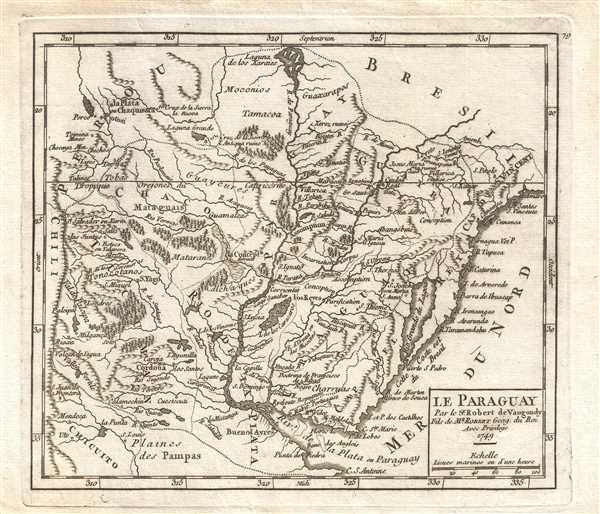
Le Paraguay. Par le Sr. Robert de Vaugondy, Fils de Mr. Robert Geog. du Roi.
1749 (dated) 7.25 x 8.5 in (18.415 x 21.59 cm) 1 : 14400000
1749 (dated) 7.25 x 8.5 in (18.415 x 21.59 cm) 1 : 14400000
Description
This is a 1749 Didier Robert de Vaugondy map of Paraguay. The map depicts from the border between Paraguay, Brazil, and Peru to Rio de la Plata and Uruguay (Uraguay) and from Chili to the Atlantic Ocean. The Laguna de los Xaraies is labeled along the top border a mysterious lake that appeared on maps of South America from about 1600 to 1850. The Laguna, located new Matte Grosso, was often associated with the gateway to the Amazon, legends of El Dorado, and the Earthy Paradise.
The name Xaraies comes from the Xarayes (a corruption of 'Xaraiés'), an indigenous people occupying what are today parts of Brazil's Matte Grosso and the Pantanal. When Spanish and Portuguese explorers first navigated up the Paraguay River, in search of El Dorado, they encountered the vast Pantanal flood plain at the height of its annual inundation. Understandably misinterpreting the flood plain as a gigantic inland sea, they named it after the local inhabitants, the Xaraies. The Laguna de los Xaraies began to appear on maps of the region and almost immediately began to take on a legendary aspect. To the north of the Laguna was believed to be the gateway to the Amazon and the Kingdom of El Dorado. Sadly, later explorers discovered that, in addition to the absence of El Dorado, the Paraguay River did not connect to the Amazon system.
Highly detailed, the map is covered in forests, mountain ranges, rivers, and lakes. Myriad cities and towns are labeled, including Asuncion (Assomption), Buenos Aires (Buenos Ayres), and Montevideo. The Rio de la Plata (Riv. De la Plata ou Paraguay) is the focal point of the lower half of the map, separating Argentina from Uruguay. South of the Rio de la Plata, the Pampas are labeled.
This map was published by Gilles Robert de Vaugondy in his Atlas Universel, Portatif et Militaire in the 1749 edition.
Cartographer
Robert de Vaugondy (fl. c. 1716 - 1786) was French may publishing from run by brothers Gilles (1688 - 1766) and Didier (c. 1723 - 1786) Robert de Vaugondy. They were map publishers, engravers, and cartographers active in Paris during the mid-18th century. The father and son team were the inheritors to the important Nicolas Sanson (1600 - 1667) cartographic firm whose stock supplied much of their initial material. Graduating from Sanson's maps, Gilles, and more particularly Didier, began to produce their own substantial corpus. The Vaugondys were well-respected for the detail and accuracy of their maps, for which they capitalized on the resources of 18th-century Paris to compile the most accurate and fantasy-free maps possible. The Vaugondys compiled each map based on their own geographic knowledge, scholarly research, journals of contemporary explorers and missionaries, and direct astronomical observation. Moreover, unlike many cartographers of this period, they took pains to reference their sources. Nevertheless, even in 18th-century Paris, geographical knowledge was limited - especially regarding those unexplored portions of the world, including the poles, the Pacific Northwest of America, and the interiors of Africa, Australia, and South America. In these areas, the Vaugondys, like their rivals De L'Isle and Buache, must be considered speculative or positivist geographers. Speculative geography was a genre of mapmaking that evolved in Europe, particularly Paris, in the middle to late 18th century. Cartographers in this genre would fill in unknown lands with theories based on their knowledge of cartography, personal geographical theories, and often dubious primary source material gathered by explorers. This approach, which attempted to use the known to validate the unknown, naturally engendered rivalries. Vaugondy's feuds with other cartographers, most specifically Phillipe Buache, resulted in numerous conflicting papers presented before the Academie des Sciences, of which both were members. The era of speculative cartography effectively ended with the late 18th-century explorations of Captain Cook, Jean Francois de Galaup de La Perouse, and George Vancouver. After Didier died, his maps were acquired by Jean-Baptiste Fortin, who in 1787 sold them to Charles-François Delamarche (1740 - 1817). While Delamarche prospered from the Vaugondy maps, he defrauded Vaugondy's window Marie Louise Rosalie Dangy of her rightful inheritance and may even have killed her. More by this mapmaker...
Source
Robert de Vaugondy, G., Atlas Portatif, Universel, et Militaire, (Paris: Vaugondy, Durand, Pissot) 1749.
Condition
Very good. Blank on verso. Original press mark visible.
References
Pedley, M. S., Bel et Utile, p. 218, 496. OCLC 431576342.