This item has been sold, but you can get on the Waitlist to be notified if another example becomes available.
1860 One-of-a-Kind Manuscript Analysis and Map of Paraguay: López Regime
ParaguayArchive-mouchez-1860$17,500.00

Title
Le Paraguay: II Etat Actuel.
1860 (dated) x in (0 x 0 cm)
1860 (dated) x in (0 x 0 cm)
Description
This is an incomparable find: an unpublished manuscript set, dated approximately 1860, consisting of maps, surveys, charts, and research notes pertaining to Paraguay, written by French naval officer and hydrographer Ernest Amédée Barthélemy Mouchez (1821 - 1892). It describes in detail Paraguay's volatile situation under dictator Carlos Antonio López Ynsfrán (née 1792, ruled 1841 - 1862,) whose autocracy set the stage for the disastrous reign of his son, Francisco Solano López Carrillo. (1827 - 1870)
The first section, Territoire, not only describes the physical features of Paraguay, but includes an exhaustive catalogue of the country's flora and fauna, both wild and domestic, edible and industrial, including categories of medicinal plants. A much shorter section details mineral resources.
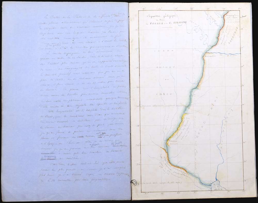
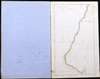
The second map proper of the manuscript is entitled Esquisse gèologique de rivier Parana et de las Paraguay. The Paraguay is shown from Asuncion to its confluence with the Rio de la Plata. The coastlines are colored to indicate swamp (most of it) as well as rocky coasts of geological interest.
Another sheet contains detailed sketches, with measurements, of what is referred to on it as 'Mouillage de l'Assomption'. These depict, further downstream, the famous batteries of La Humaita, known as the 'Gibraltar of the South' and renowned as utterly impregnable to wooden ships. The batteries were easily bypassed in 1868 during the war of the Triple Alliance by Brazilian Navy ironclads.
Included are also Mouchez' own detailed sketches of the fortifications commanding the anchorage of Asuncion, and coastal views of the Paraguay River. Mouchez' observations reveal the country in intimate, granular detail; unsurprisingly, close attention is paid to Paraguay's army and its composition - even enumerating the typical salaries for officers, enlisted men, and musicians.
A Closer Look
From 1857 to 1859 aboard the steamship Bisson, Mouchez undertook surveys of the Rio de la Plata and the Rio Parana which would inform several charts published by the Depot des Marine. Despite containing two detailed manuscript maps, the manuscript's scope goes far beyond the hydrographic surveys for which Mouchez is better known. Its focus on the government and military of the Republic of Paraguay suggests that - as the Paraguayan government apparently accused - Mouchez' work is one of espionage, intended for the French. Mouchez's 1862 map of the country, derived from this research, was used as a reference by the Triple Alliance to draw the new border along the Igurey river.Paraguay on the Road to Disaster
The manuscript's information was gathered during the presidency of Carlos Antonio López Ynsfrán. Power would not pass to his son, Francisco Solano López Carrillo, until 1862. However, the seeds for Francisco Solano's hubris (leading to his own death and the virtual annihilation of his country in the War of the Triple Alliance 1864 - 1870) can be found in the dictatorial rule of the father, whose ambitions to fashion Paraguay as a power to rival its neighbors repeatedly threw the little country into conflict, including an 1855 exchange of fire with a U.S. Navy survey ship on the Paraná.Structure and Content
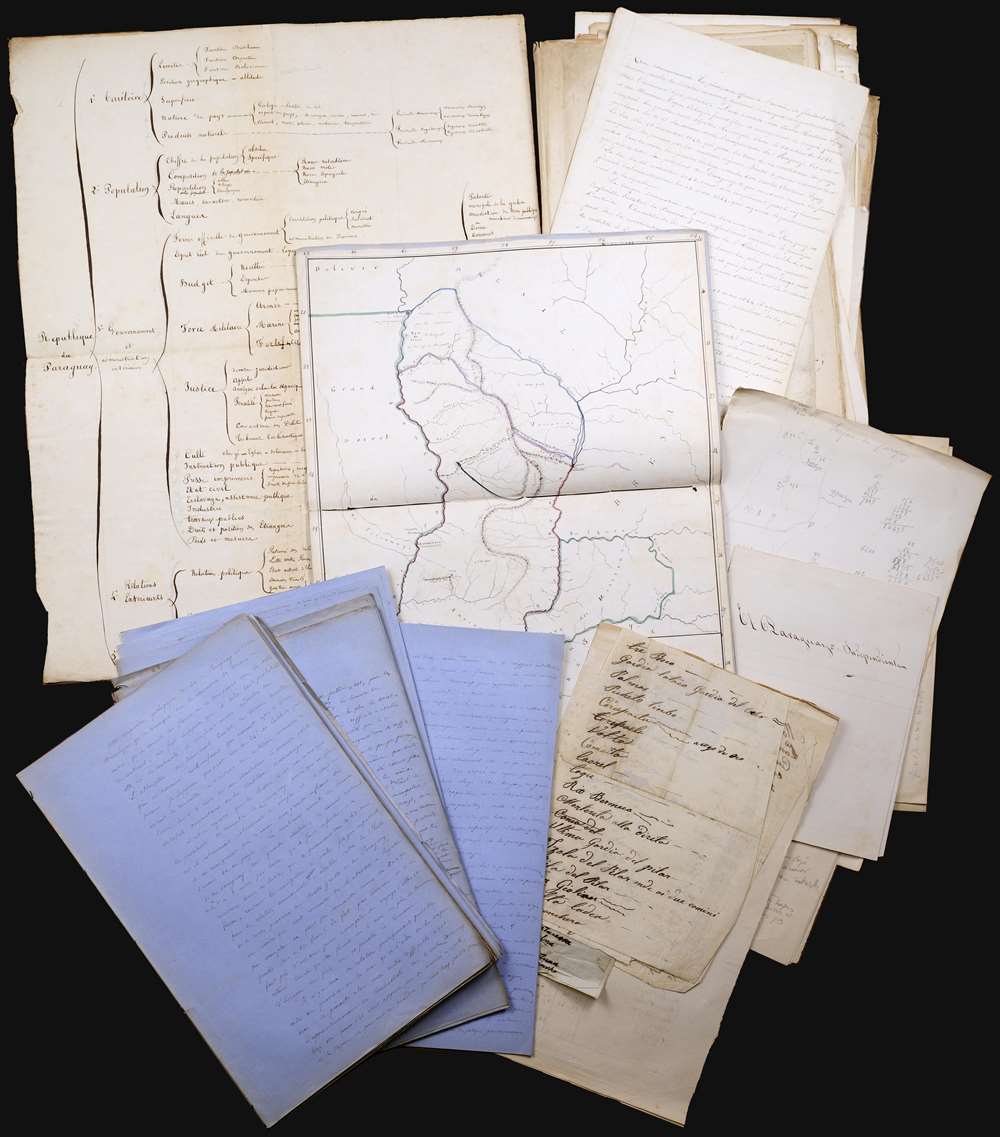
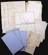
The archive contains a fair copy of the manuscript, but is also accompanied by several rounds of draft manuscripts, including copious notes. There is in addition a table of contents, in the form of an organizational outline (of which there is also a draft copy). Comparisons of the two outlines are instructive in helping determine what portions of the manuscript are complete, which ones may be missing or unfinished, and areas which, although not outlined, commanded Mouchez' attention. For example, the body of the fair copy is entitled 'II - Etat Actuel.' While the fair copy outline entitles the whole as 'Republique du Paraguay,' the draft uses the heading 'II - Etat Actuel' while noting parenthetically that this was to follow a ' I - Abregé historique'. This 'Abridged History' does not appear in the fair copy, although portions of it can be found amongst the earliest tier of drafts in the archive. Consequently, the focus of this manuscript in its most complete form is not on the history of Paraguay, but on the state of the country contemporaneous to the writing of the manuscript, and of Mouchez' own exploration of the place. It is a time-sensitive work of intelligence reconnaissance.The first section, Territoire, not only describes the physical features of Paraguay, but includes an exhaustive catalogue of the country's flora and fauna, both wild and domestic, edible and industrial, including categories of medicinal plants. A much shorter section details mineral resources.
The Maps
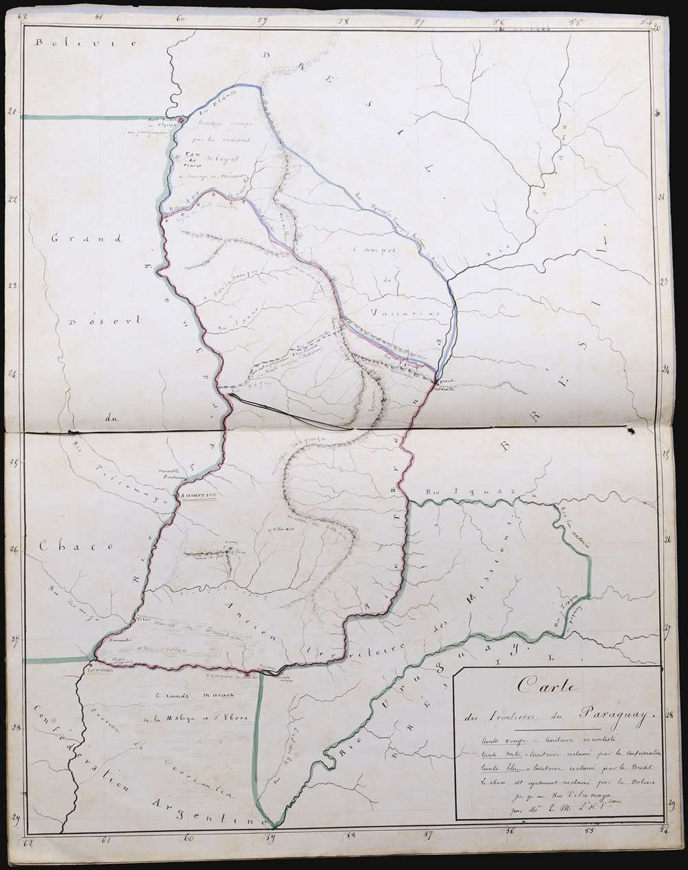
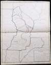
This section is of most interest from a cartographic point of view, for it contains the maps of the archive. The first and largest of these is titled Carte des Frontieres du Paraguay. This is a meticulous and expert manuscript map of Paraguay and its neighbors, from 20 - 29° S and from 54 - 6° W. Neat hachure indicates swampland, and mountains are shown pictorially with a delicate gradation indicating their relative size. Rivers, of paramount importance to Paraguay's borders, are clearly depicted and named. Assumption, the capital, is prominently marked. Border outlines are heightened with watercolor in red, blue and green, emphasizing the truth of the country's strategic situation: a nation entirely surrounded by belligerent neighbors with counter-claims on much of her notional territory. Paraguay's incontrovertible borders are marked in red. Blue marks outline the northern frontier, contested by Brazil. This area north of the rivers Apa and Aguaray runs north to fort Olympus at the mouth of the Rio Blanco and encompasses the Campos de Vaccarias up to the Parana River. To the south and west, too, territory claimed by Paraguay is contested by the Argentine Confederation. The Missiones between the Rivers Parana and Uruguay, and the Chaco, the territory of the west bank of the Paraguay River, extending from Corrientes to Fuerte Olympo. These areas are outlined in green. The cartouche text further notes that the area of the Chaco is also claimed by Uruguay.The second map proper of the manuscript is entitled Esquisse gèologique de rivier Parana et de las Paraguay. The Paraguay is shown from Asuncion to its confluence with the Rio de la Plata. The coastlines are colored to indicate swamp (most of it) as well as rocky coasts of geological interest.
Another sheet contains detailed sketches, with measurements, of what is referred to on it as 'Mouillage de l'Assomption'. These depict, further downstream, the famous batteries of La Humaita, known as the 'Gibraltar of the South' and renowned as utterly impregnable to wooden ships. The batteries were easily bypassed in 1868 during the war of the Triple Alliance by Brazilian Navy ironclads.
Mouchez as Naturalist
A significant portion of the archive is given over to the natural constitution of Paraguay. Mouchez details both domestic and wild animals, including reptiles, birds, insects. Many of these elements impinged upon the economic features of the country, so are consistent with the overall character and depth of the document. Similarly, he details the vegetation, distinguishing between edible and medicinal plants, and those - such as yerba mate, cotton and tobacco - which were exports, or otherwise industrially exploitable.Other Content
The archive further consists of a pencil draft, accompanied by a fair copy in pen. The drafts include a transcription of the 1856 recognition of Paraguayan independence by the Argentine Confederation, and there are transcriptions of international law - specifically articles 108 and 109 of the 1815 Congress of Vienna - pertaining to the navigation of rivers. This impacted Paraguayan foreign policy directly, specifically in the declaration that rivers crossing or abutting more than one nation should be free to commerce. (This decision meant that Paraguay's practice of detaining Brazilian traffic contravened international policy.) Elsewhere in the archive, President Lopez' preoccupation with control over Paraguay's rivers is pointed out, with the Water-Witch incident of 1855 raised as an example.Included are also Mouchez' own detailed sketches of the fortifications commanding the anchorage of Asuncion, and coastal views of the Paraguay River. Mouchez' observations reveal the country in intimate, granular detail; unsurprisingly, close attention is paid to Paraguay's army and its composition - even enumerating the typical salaries for officers, enlisted men, and musicians.
Cartographer
Ernest Amédée Barthélemy Mouchez (1821 – 1892) was a French naval officer and hydrographer. Mouchez was born in Madrid, but started his career with the French Navy in 1843. Although he was famed for his heroic defense of the port of Le Havre during the Franco-Prussian war, his experience with the navy was primarily one of exploration, rather than warfare. He served on surveys of the coasts of Algeria, Korea, and China, but most particularly South America; he would publish in 1868 Positions géographiques des principaux points de la cote orientale de l'Amérique du Sud comprise entre la Guyane française et le Paraguay d'après les campagnes du Bisson, du D'Entrecasteaux et du Lamotte-Piquet, de 1856 a 1866, a gazeteer of the latitudes and longitudes of points along the South American coast; his surveys also informed navigational manuals of the Rio de la Plata, and a detailed map of the Paraná province. From 1857 to 1859 he executed extensive surveys of the Paraguay River, and several maps and charts of Paraguay and the Plata region cite his efforts. He appears to have engaged in an in-depth study also of Paraguay under the leadership of the dictatorial President Carlos Antonio López Ynsfrán (1792-1862). His efforts apparently earned him the ire of that President, and what appear to have been completely justified accusations of espionage. A detailed manuscript study of Portugal under Lopez survives, but was never published: Mouchez's surveys and astronomical efforts were well-published so it appears likely that if he had wished to publish the Paraguay survey, he could well have done: after all, just a few years later under Lopez's son Paraguay would be embroiled in the notorious war of the Triple Alliance. It may be that Mouchez's study was meant for the eyes of the French Government, rather than general publication.
Mouchez's efforts in the realm of navigation and astronomy were well regarded. He contributed new techniques for surveying at sea and precisely determining longitude. In 1873 he was elected to the Bureau des Longitudes. in 1874 he was sponsored by the Académie des sciences to observe the transit of Venus from St. Paul Island in the Indian Ocean, resulting in a remarkable photographic record of the transit. By 1875 he was a member of the astronomy section of the Académie. Appointed in 1778 director, and tasked with the reconstruction of the Paris Observatory, which had become ruined during the course of the 1870 war and the 1871 Paris Commune. Late in life he collaborated with Sir David Gill to produce a photographic celestial atlas, the Carte du Ciel, a project which stalled and faded as it became superceded. More by this mapmaker...
Condition
Good. Autograph manuscript, 17 notebooks, [2] ff., 217, [120] pp., with two maps drawn in ink and colored in outline, an ink and watercolor drawing and a watercolor in the text. The text with some corrections and ink somewhat faded but still perfectly legible The two outlines/tables of contents are 21 x 17 inches for the fair copy and 18 x 14 for the draft. The manuscript books are all 14 x 9 inches, the predominant size of sheet for the other notes as well, although many of the notes are on smaller sheets. The main map of Paraguay is 18 x 13.5 inches; the smaller is 13 x 7.5 inches.