This item has been sold, but you can get on the Waitlist to be notified if another example becomes available, or purchase a digital scan.
1710 Elizabeth Verseyl Visscher map of Patagonia and Tierra del Fuego
ParaguayChile-visscher-1710$1,250.00

Title
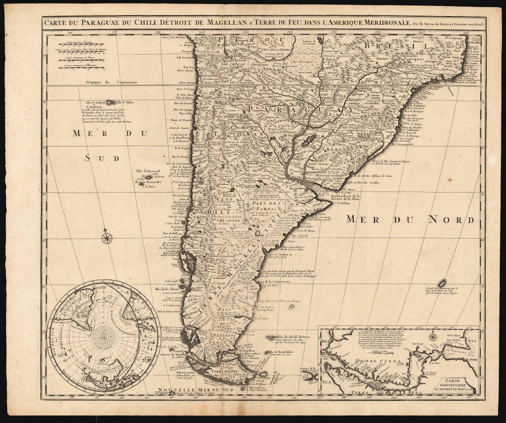
Carte du Paraguay, du Chili, Détroit de Magellan, et Terre de Feu dans l'Amerique Meridionale.
1710 (undated) 19.75 x 23 in (50.165 x 58.42 cm) 1 : 9500000
1710 (undated) 19.75 x 23 in (50.165 x 58.42 cm) 1 : 9500000
Description
This is Elizabeth Verseyl Visscher's scarce, c. 1710 map of southern South America, based on the 1703 map by Guillaume De l'Isle. It is notable in particular for being the first published map to include a new, 1702 charting of the Strait of Magellan, which had been suppressed by the Chancellor of France, the Comte de Pontchartrain.
The map presents a broadly accurate and detailed mapping of both the east and west coasts. The Rio de la Plata is presented to suggest relatively easy navigation along it and its tributaries, as well as the relative narrowness of the continent and accessibility of the Pampas.
There are several instances, in institutional collections, of the present map being credited to Nicolaes Visscher II, dated 1702 (on the strength of his death that year) or even 1701 (on the strength of the 'Isle de Beauchesue'). These are not credible and appear to be fueled in part by a chauvinist assumption that the widow Visscher cannot have produced any such new work in her husband's atlas. Not only the selection of an excellent source, but also the introduction of the two insets of sharp and current topical interest, suggest that Verseyl Visscher was guiding the family business actively forward.
On The Map
The work covers roughly from 18 degrees south latitude south to Tierra del Fuego, and includes the modern-day nations of Paraguay, Chile, Uruguay, and Argentina, along with the southern portions of Brazil and Bolivia. The map renders the entire region in extraordinary detail, offering both topographical and political information with forest and mountains beautifully rendered in profile.A State-of-the-Art Work
Nicolaes Visscher's Atlas Minor did not have a map equivalent to this one, or even a specific map of South America. Some examples of the atlas survive that include a tipped-in Jansson or, in 1708, include a Mortier edition of De l'Isle's South America. Following Nicolaes' death in 1702, his widow Elizabeth continued to build on her husband's atlas, drawing on the most current cartographers to do so. In this case, the source was Guillaume de l'Isle's 1703 Carte du Paraguay, du Chili, du Detroit de Magellan etc. That map was itself derived from the firsthand account of Alfonse d'Ovalle, and additional reports from de Brouwer, Narborough, and de Beauchêne. Verseyl Visscher's copy of the De l'Isle is an extremely precise and faithful rendition of the 1703 map, to the extent of preserving the original French text (although the occasional misspelling reveals this Dutch map to be a copy of the French, and not the other way around).The map presents a broadly accurate and detailed mapping of both the east and west coasts. The Rio de la Plata is presented to suggest relatively easy navigation along it and its tributaries, as well as the relative narrowness of the continent and accessibility of the Pampas.
Alternatives to Magellan's Strait
One of the interesting speculations is De l'Isle's depiction of the Santa Cruz River, or the 'Rio St. Julien', nearly connecting with the Rio de la Campana coming from the Pacific, thus connecting the Atlantic to the South Seas via an easy overland river route. The idea of a river route crossing Patagonia caught the European imagination in the early 18th century. The writer Daniel Defoe proposes a similar route further north in his book A New Voyage, and such concepts appeared in several maps of the period including Herman Moll's important map of the South Sea Company. Of course, the Andes are in fact an indomitable barrier and short of the treacherous Strait of Magellan itself, no such water route existed. Some other interesting elements of this map appear far from the mainland in the surrounding seas. The Falklands are depicted in an embryonic form as identified by Captain La Roche in 1675. Just above the inset, another island appears, supposedly discovered by La Roche in 1675, and is mostly likely a mis-mapping of South Georgia Island. The most recent discovery shown on the map is the Isle de Beauchesue, 'decouverte en 1701'. This is a telling misspelling: De l'Isle has it as the Isle de Beauchesne, or Beauchesne Island, the southernmost of the Falkland Islands, named after its discoverer Jacques Gouin de Beauchêne. Thus, we have an error produced by a Dutch engraver copying a French map - concrete evidence that Verseyl Visscher had this copied from the 1703 De l'Isle.The Insets
The two lower insets do not appear on the 1703 De l'Isle, and were newly included in this version of the map. To the lower left is a detailed south polar projection - this appears to be a reduction of De l'isle's 1703 Hemisphere Meridional. We do not see any map in Visscher's 17th century oeuvre that compares to it, despite the fact that the majority of its information reflects the mid-seventeenth century explorations of Abel Tasman. The delineation here includes western Australia and New Zealand, the southern coast of Tasmania, and the other islands discovered in the southern Pacific, Indian Ocean, and the Atlantic. None of this would be improved materially until the 1768-71 voyage of Captain Cook. The inclusion here of this south polar projection serves mainly to visually contextualize the main body of the map and emphasize that as yet no further point south had been achieved than Tierra del Fuego. The inset to the lower right is a detail of the Strait of Magellan, and it is remarkable enough to warrant special attention.Suppressed Geography
As with the polar projection to the left, this mapping of the Strait of Magellan did not appear on any earlier edition of De l'Isle's Carte du Paraguay - despite it having been possible for it to be included. We have identified Visscher's source. In 1702, letters passed between Jacques Gouin de Beauchêne and the powerful Comte de Pontchartrain. Beauchêne had led, between 1698 and 1701, the first French trading expedition to the Pacific, passing through the Strait of Magellan in 1699 and returning via Cape Horn on January 9, 1701. In 1702, Beauchêne had alerted Pontchartrain that his former ship's chaplain (a Mr. de la Morlière, about whom we know virtually nothing) intended to publish a description of the 1698-1701 voyage, including a map. Concerned that crucial navigational secrets might pass to rivals, Beauchêne requested that Pontchartrain suppress the account. Pontchartrain's September 13, 1702, response survives:I received the letter which you wrote to me on the 6th of this month with the map of the Strait of Magellan which the Sieur de la Morlière dedicated to the Bishop of Viviers. I took measures to prevent its printing, as well as of the book he is making of the South Sea Voyage.The suppressed 1702 map survives in three, incorrectly dated, copies (the British Library, the Bibliotheque National de France, and the Paris Museum of Natural History). This map, Carte du détroit de Magellan Dressée sur les mémoires de Mr. de la Morlière… Dédiée à Monseigneur l'Evêque de Viviers is identical in its detail and informational text as the inset in Verseyl Visscher's 1710 map. The Morlière Carte du détroit de Magellan bears the engraver's imprint of Jean Baptiste Liebaux, who engraved the 1703 De l'Isle Paraguay along with many other of De l'Isle's works. So, Pontchartrain's interdict worked: Morlière's cartography makes no appearance on De l'Isle's 1703 map, despite its inclusion of Beauchêne's newly-discovered island. Neither does the Morlière geography appear on the Renard states of De l'Isle's map, intended for sale in Amsterdam. It is on Verseyl Visscher's 1710 map that Morlière's Strait of Magellan makes its first appearance, unhindered by French censorship. The original Morlière map, surviving in only three known examples, was so successfully suppressed that no institution holding it has correctly identified its date or context. The waters are muddied by the existence of a Gerard Van Keulen manuscript in the collection of the University of Leiden. This large folio bears the same title as the Liebaux, including Morlière's name and the dedication to the bishop of Viviers. The van Keulen bears the date 1723. It adds insets that do not exist on the Liebaux, and is either an embellishment of the 1702 map or shares the same manuscript source.
There are several instances, in institutional collections, of the present map being credited to Nicolaes Visscher II, dated 1702 (on the strength of his death that year) or even 1701 (on the strength of the 'Isle de Beauchesue'). These are not credible and appear to be fueled in part by a chauvinist assumption that the widow Visscher cannot have produced any such new work in her husband's atlas. Not only the selection of an excellent source, but also the introduction of the two insets of sharp and current topical interest, suggest that Verseyl Visscher was guiding the family business actively forward.
Publication History and Census
This map was engraved in about 1710 for inclusion in the Visscher Atlas Minor; we have seen only a single state of the map. We see eighteen examples listed in institutional collections.CartographerS
Elizabeth Verseyl Visscher (16?? - 1726) was a Dutch atlas publisher. It is not known when she was born, and nothing is known of her education. On December 10, 1680, she married mapmaker Nicolaes Visscher II (1649 – May 31, 1702). When Nicolaes died, Elizabeth ran the business, both continuing to publish Nicolaes' maps and adding to the company's oeuvre until 1726, at which point the stock of copperplates was sold to Peter Schenk. (It is not known whether the sale preceded her death, or was posthumous.)
We are not aware of any instance of Verseyl Visscher's name appearing on a map; rather she is identified as 'Widow of Nicolaes Visscher.' More by this mapmaker...
Guillaume De l’Isle (1675 - 1726) was a French cartographer, and arguably the finest mapmaker at the beginning of the eighteenth century. He was the son of Claude De L'Isle (1644 -1720), a Paris-based historian and geographer under Nicholas Sanson, then the leading light of French cartography. He was the chief proponent of the school of 'positive geography' and the primary figure defining the heights of the Golden Age of French Cartography. Guillaume's skill as a cartographer was so prodigious that he drew his first map at just nine years of age. He was tutored by J. D. Cassini in astronomy, science, mathematics and cartography. By applying these diverse disciplines to the vast stores of information provided by 18th century navigators, Guillaume created the technique that came to be known as 'scientific cartography', essentially an extension of Sanson's 'positive geography'. This revolutionary approach transformed the field of cartography and created a more accurate picture of the world. Among Guillaume's many firsts are the first naming of Texas, the first correct map of the Mississippi, the final rejection of the insular California fallacy, and the first identification of the correct longitudes of America. Stylistically De L'Isle also initiated important changes to the medium, eschewing the flamboyant Dutch style of the previous century in favor of a highly detailed yet still decorative approach that yielded map both beautiful and informative. Guillaume was elected to the French Academie Royale des Sciences at 27. Later, in 1718, he was also appointed 'Premier Geographe du Roi', an office created especially for him. De L'Isle personally financed the publication of most of his maps, hoping to make heavy royalties on their sales. Unfortunately he met an untimely death in 1728, leaving considerable debt and an impoverished child and widow. De L'Isle's publishing firm was taken over by his assistant, Phillipe Buache, who would also become his son in law. Learn More...
Source
Visscher, N. II, Atlas Minor, (Amsterdam: Visscher) c. 1710.
Condition
Very good. Two mends at bottom folds with no loss. Few spots and marginal stains. Else a bold strike with generous margins.
References
OCLC 71538294. Dahlgren, Erik Wilhelm Les relations commerciales et maritimes entre la France et les côtes de l'océan Pacifique: Le commerce de la mer du Sud jusqu'a la paix d'Utrecht 1909 pp. 134-135.