This item has been sold, but you can get on the Waitlist to be notified if another example becomes available, or purchase a digital scan.
1857 Depot de Guerre Map of Paris, France and its Monuments
Paris-depotdeguerre-1857$300.00

Title
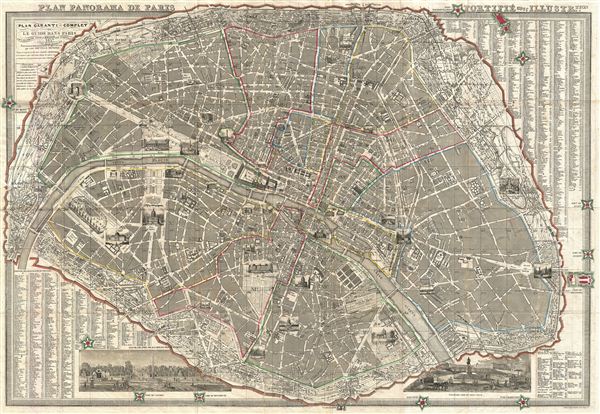
Plan Panorama de Paris Fortifie avec Illustre.tion.
1857 (dated) 24 x 35 in (60.96 x 88.9 cm)
1857 (dated) 24 x 35 in (60.96 x 88.9 cm)
Description
A fine tourist 1857 pocket map of Paris drawn by Armand Joseph Lallemand issued by the Depot de Guerre. Centered on the Seine, Lallemand's map covers central Paris as contained by the Thiers Wall. The city is shown at the very beginning of the Haussmann's renovation of the city, so many of Paris' original streets remain intact. Gardens, monuments, and parks are illustrated either in profile or in the form of vignette engravings – making this an ideal companion for the curious tourist. Indexes in the lower left, upper right, and lower right quadrants detail various streets throughout the city, each with a reference attaching it to numbered grid. In the lower right and the lower left quadrants that are two larger vignette views, the first depicting the gate entrance to the Tuileries Garden, and the second depicting the Pont Neuf. Districts, perimeter forts, and the Thiers Wall are highlighted in color. Drawn by Lallemande and issued by the Depot de Guerre, Paris.
CartographerS
Armand Joseph Lallemand (c. 1810 - 1871) was an engraver and map publisher based in Paris during the mid-19th century. Most of Lallemand's work focused on landscapes and building vies, though he did take part in a few cartographic ventures, including the production of an atlas with Alexandre Emile Lapie and several tourist pocket maps of Paris. More by this mapmaker...
Depot de Guerre (1688 - 1887) was a branch of the French military devoted to creating, collecting, and publishing military memoirs, plans, and maps. The Depot was founded in 1688 by Francois Michel le Tellier, the Marquis de Louvois. Louvois held the post of Secretary of State for War under Louis XIV and his best known for composing the first letter regarding the mysterious "Man in the Iron Mask". During the French Revolution and the Napoleonic Wars the Depot de Guerre expanded its operations to include any and all topographical research in France. In 1887 the Depot de Guerre was disbanded and its duties split between the Institut Geographique National (IGN) and the Service Historique de L'Armee (SHA). Learn More...
Condition
Very good condition. Original fold lines exhibits some wear and occasional archival verso reinforcement - especially at intersections. Attached to original linen binder.
References
Vallee, Leon, Catalogue des plans de Paris et des cartes de l'ile de France, (Bibliotheque Nacionale) 3493 (Ge C 3748).