This item has been sold, but you can get on the Waitlist to be notified if another example becomes available, or purchase a digital scan.
1844 Girard City Map or Plan of Paris, France
Paris-girard-1844$300.00

Title
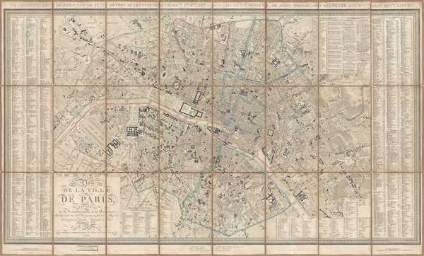
Plan de la Ville de Paris Divisé en 12 Arrondissemens, et 48 Quartiers. Indiquant tous les Changemens faits et Projetés.
1844 (dated) 23.5 x 39.25 in (59.69 x 99.695 cm) 1 : 11800
1844 (dated) 23.5 x 39.25 in (59.69 x 99.695 cm) 1 : 11800
Description
This is an 1844 Xavier Girard city map or plan of Paris, France. The map depicts the city from the Arc de Triomphe to the Place de la Nation (labeled here as the Place du Trône) and from the village of Montmartre to the Place d'Italie. Incredibly detailed, nearly every street in the city is labeled, along with innumerable buildings and monuments. Paris in 1844, although resembling the Paris of today, bore some striking differences. The 'Haussmannization' of Paris would not begin for nearly another decade, meaning that the warren of small streets that were an integral part of 17th, 18th, and early 19th century Paris still existed. The Arc de Triomphe, l'Avenue des Champs-Elysées and the Jardin des Tuileries (Tuileries Garden) are all as they appear in Paris today, but the Louvre is different. In 1844, the Palais des Tuileries still stood, blocking public access to the Palais du Louvre. The Jardin des Plantes is referred to here as the Jardin du Roi (King's Garden), since it was, then, the property of the restored French monarchy. Each of the arrondissements is labeled with Roman numerals and outlined in a different color. A street index is included along both the left and right borders, with two supplemental indexes along the bottom border.
This is an extremely rare city map of Paris. We were unable to locate any examples of the 1844 edition in any institutional collections. This map was produced by Xavier Girard and published by J. Goujon and J. Andriveau in 1844.
This is an extremely rare city map of Paris. We were unable to locate any examples of the 1844 edition in any institutional collections. This map was produced by Xavier Girard and published by J. Goujon and J. Andriveau in 1844.
Cartographer
Xavier Girard (fl. c. 1820 - 1844) was a French cartographer known for publishing a series of city maps or plans of Paris from 1820 until at least 1844. More by this mapmaker...
Condition
Good. Backed on very fragile linen. Linen reinforced in certain places.