This item has been sold, but you can get on the Waitlist to be notified if another example becomes available, or purchase a digital scan.
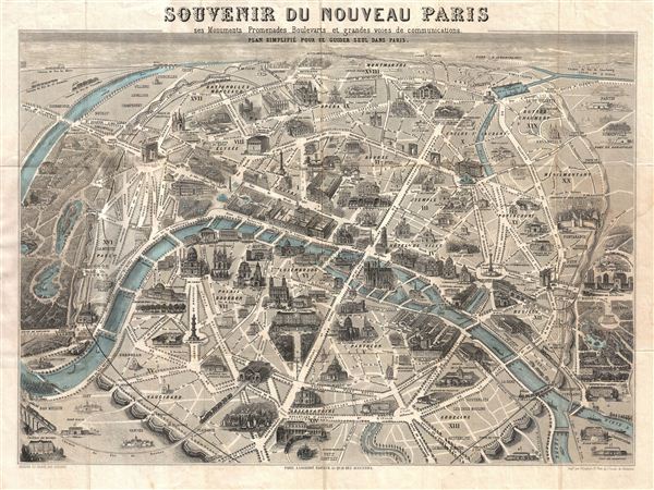
1867 Guesnu Map of Paris and its Monuments, France
Paris-guesnu-1867$275.00

Title
Souvenir du Nouveau Paris ses Monuments Promenades Boulevards et grandes Voies de Communications.
1867 (undated0 16 x 22 in (40.64 x 55.88 cm)
1867 (undated0 16 x 22 in (40.64 x 55.88 cm)
Description
An exceptional 1867 monumental map and view of Paris, France. Drawn by Henri Guesnu, this map, as the title suggests, is a map of the 'New Paris,' as redesigned and rebuilt under Napoleon III by Baron Geroges-eugene Haussmann. Known in French as the Grands Travaux, Haussmann's redesign of Paris defined it as a modern city, with narrow alleyways and confusing streets replaced by a broad network of grand boulevards, imposing facades, parks, and monuments. This map, which was prepared with the tourist in mind, shows major monuments in profile and is one of the earliest and most appealing examples of its genre. Published by A. Logerot of 55 Quai des Augustins, Paris.
CartographerS
Marie-Hilaire Guesnu (January 10, 1820 - November 11, 1868) was a artist and engraver active in Paris during the mid-19th century. He worked with a number of contemporaneous publishers, including Auguste Logerot (fl. c. 1839 - c. 1880) and Charles Chardon (1832 - 1896). He exhibited at the Paris Salon between 1842 and 1865. Cartographically he is known for two exceptionally desirable view maps of Pairs, his tourist monument map of Paris, and a view of Paris from the Bois de Boulogne. We have discovered considerable confusion regrading his dates. The most conventional dates are 1820 - 1868, but we also see 1802 - 1880, 1801 - 1868, and 1808 - 1880. More by this mapmaker...
Auguste Logerot (fl. c. 1839 - c. 1880) was a French map and general interest publisher active throughout the mid to late 19th century. A. Logerot worked with other French publishers, cartographers and engravers of the period including Fremin, Dufour, Dyonnet, and Vuillemin. He published a large corpus of map and geographical atlases, though few of his map represented unique or exceptionally interesting work. This exception are his wonderful jigsaw puzzle maps - a style popular in 19th century France. Jigsaw puzzle maps are a kind of educational map printed on board and carved up in puzzle format. Logerot's imprint is frequently misprinted as Lagerot or Logeret. Logerot shared offices with several other publishers, printers and engravers at Quai des Augustins 55, Paris. Little else is known of Logerot's life and work. Learn More...
Condition
Very good. Original fold lines exhibit some wear. Old closed repair from top through 'u' in 'Souvenir' extending 1/3 of the way into the page - not exceptionally noticeable - see image. Folds into original binder.
References
Vallee, Leon, Catalogue des plans de Paris et des cartes de l'ile de France, (Bibliotheque Nacionale) 1964-1965.