This item has been sold, but you can get on the Waitlist to be notified if another example becomes available, or purchase a digital scan.
1802 Chez Jean Map of Paris in 12 Municipalities, France
Paris-jean-1802$400.00

Title
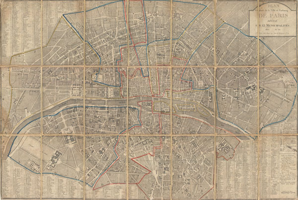
Plan Routier de la Ville et Faubourg de Paris Divise en 12 Municipalities.
1802 (dated) 22.56 x 33 in (57.3024 x 83.82 cm)
1802 (dated) 22.56 x 33 in (57.3024 x 83.82 cm)
Description
An extraordinary map of pre-Haussmann Paris and the early Faubourgs (suburbs) issued in 1802, following Napoleon Bonaparte's 1800 reorganization of the city into 12 Municipalities. Covers Paris on both sides of the Seine from the Champ de Mars to Le Trone, extends north as far as Montmarte and south roughly to Port Royal. Produced at the height of French dominance of the cartographic arts, this maps is a fine example the engraver's art. Individual buildings, fields, streets, hills, valleys, orchards, and public gardens are revealed in breathtaking detail. We can even see the incomplete state of the northern wing of the Louvre Palace. There is an elaborate street index on either side and at the bottom of the map. In the lower right quadrant appears a list of names of the ministers in charge of the Municipalities. This is an update of a similar street plan made by the same publisher in 1797.
This type of map, known as a Pocket or Case Map, is designed with the traveler in mind and while it display's beautifully unfolded, is designed to fold and fit in a vest or coat pocket. It accordance with its purpose, the map has been dissected and mounted on linen in 21 sections. This system was devised in the 18th century to protect folding maps against damage caused by repeated folding and unfolding. The linen backing absorbs the stress of folding and can easily be mended or replaced, this preserving the integrity of the actual paper document.
This type of map, known as a Pocket or Case Map, is designed with the traveler in mind and while it display's beautifully unfolded, is designed to fold and fit in a vest or coat pocket. It accordance with its purpose, the map has been dissected and mounted on linen in 21 sections. This system was devised in the 18th century to protect folding maps against damage caused by repeated folding and unfolding. The linen backing absorbs the stress of folding and can easily be mended or replaced, this preserving the integrity of the actual paper document.
Cartographer
Pierre Jean (1754 - 1829) was a French engraver, publisher, print seller, and map maker active in Paris in the late 18th and early 19th centuries. Jean entered the engraving and printing business on June 7 of 1784 when he married the daughter of Louis-Joseph Mondhare, a prominent French engraver, print seller and map publisher. Mondhare changed the name of his firm to Mondhare & Jean. Under Mondhare, for about 12 years, Jean mastered the in-and-outs of the engraving and map publishing business. Mondhare retired in 1796, leaving Jean his business and printing plates. Jean subsequently continued to publish on his own account, as Chez Jean, from the old Mondhare & Jean offices at 32 Rue Saint-Jean de Beauvais. More by this mapmaker...
Condition
Very good. Overall age toning. Some edge wear. Original linen backing.
References
National Library of Australia, MAP RM 1378. Vallee, Leon, Catalogue des plans de Paris et des cartes de l'ile de France, (Bibliotheque Nacionale) 1644.