This item has been sold, but you can get on the Waitlist to be notified if another example becomes available, or purchase a digital scan.
1948 Leconte Pictorial Map of the Environs of Paris, France
Paris-leconte-1948$87.50

Title
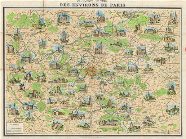
Monuments et Vues des Environs de Paris.
1948 (undated) 20.25 x 27 in (51.435 x 68.58 cm) 1 : 232000
1948 (undated) 20.25 x 27 in (51.435 x 68.58 cm) 1 : 232000
Description
An attractive and decorative 1948 map of the environs of Paris by A. Leconte. Centered on Paris, the map extends roughly 50 miles in all directions, cover from Chartes to Soissons and from Fleury sur Andelle to Sergines. Roads, rail lines, rivers, bridges, and forests are indicated throughout. Historical sites and monuments are rendered via vignettes, making this map exceptionally decorative. Leconte first issued this map in 1928. It proved extremely popular and went through many updates and revisions until about 1954. It was originally drawn by F. del Menetrier.
Cartographer
André Leconte (fl. 1880 - 1930) was a Paris based guidebook and map publisher active in the latter part of the 19th and early 20th centuries. He is one of the publishers of the attractive art nouveau style "Nouveau Paris Monumental" series. Leconte is often associated with L. Guilmin, another Paris based map publisher of the same period. Early in World War II (1939 - 1945) the firm published anti-German propaganda, but briefly shut down operations during the occupation. Leconte's name appears on maps and guidebooks of Paris well after his death (though we can't date this event with any precision) to about 1980. More by this mapmaker...
Condition
Good. Backed with archival tissue for stability. Some wear on original fold lines. Minor damage on verso from application of old cellophane tape. Printed map of central Paris on verso.