This item has been sold, but you can get on the Waitlist to be notified if another example becomes available, or purchase a digital scan.
1860 Logerot Map of Paris, France
Paris-logerot-1860$275.00

Title
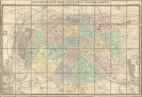
Nouveau Plan de Paris Divise en 20 Arrondissements Dans un rayon de 10 kilometres.
1860 (dated) 29 x 43 in (73.66 x 109.22 cm)
1860 (dated) 29 x 43 in (73.66 x 109.22 cm)
Description
This is a large 1860 pocket map of Paris by A. Logerot. It covers the embastilled center of Paris as well as its immediate vicinity, including the Bois de Boulogne and Bois de Vincennes. Fine detail is present throughout the map, with important buildings and monuments, gardens, rivers, roadways, and various other topographical features are identified. Color coded by arrondissement. All text is in French. A table on the upper left quadrant notes the various districts and neighborhoods in Paris. The fortifications surrounding Paris are particularly highlighted.
Paris, at this time, was undergoing a major urban renewal project under the direction of Baron Georges-eugene Haussmann. This project, begun in 1853 and completed in 1870, called for new regularly updated maps of Paris. The use of the term 'Nouveau Plan de Paris' for most maps published during and shortly after this period thus become common. Haussmann's renovations transformed the mediaeval city and created the Paris we know and love today - a city of broad spacious boulevards and lively street side cafes. Some of tse renovations are shown in manuscript, an update that we have seen on several examples of this map suggesting it is the work of the publisher.
Logerot first issued this map in 1859 and updated annually it through the 1880s. This is the second edition, 1860.
Cartographer
Auguste Logerot (fl. c. 1839 - c. 1880) was a French map and general interest publisher active throughout the mid to late 19th century. A. Logerot worked with other French publishers, cartographers and engravers of the period including Fremin, Dufour, Dyonnet, and Vuillemin. He published a large corpus of map and geographical atlases, though few of his map represented unique or exceptionally interesting work. This exception are his wonderful jigsaw puzzle maps - a style popular in 19th century France. Jigsaw puzzle maps are a kind of educational map printed on board and carved up in puzzle format. Logerot's imprint is frequently misprinted as Lagerot or Logeret. Logerot shared offices with several other publishers, printers and engravers at Quai des Augustins 55, Paris. Little else is known of Logerot's life and work. More by this mapmaker...
Condition
Very good. Dissected and mounted on linen. Original linen backing fragile and split in places.
References
Vallee, Leon, Catalogue des plans de Paris et des cartes de l'ile de France, Bibliotheque Nacionale, 1936 (Ge FF 9735).