This item has been sold, but you can get on the Waitlist to be notified if another example becomes available, or purchase a digital scan.
1867 Logerot Map of Paris, France
Paris-logerot-1867$275.00

Title
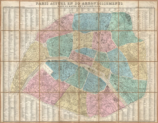
Paris Actuel en 20 Arrondissements dan un rayon de 7 kilometres.
1867 (undated) 24 x 31 in (60.96 x 78.74 cm)
1867 (undated) 24 x 31 in (60.96 x 78.74 cm)
Description
A stunningly folding map of Paris, France, dating to 1867. Logerot drew this map to illustrate Napoleon III and Georges-Eugène Haussmann's revolutionary modernization of Paris. Shows the 1860 repartitioning of the arrondissement system into 20 distinct zones as well as Haussmann's broad networks of avenues and thoroughfares. Elegant highly detailed engraving reveals important buildings, parks, streets, and fortifications. Dissected and mounted on linen in 32 panels for easy folding and unfolding. Published by the A. Logerot.
Cartographer
Auguste Logerot (fl. c. 1839 - c. 1880) was a French map and general interest publisher active throughout the mid to late 19th century. A. Logerot worked with other French publishers, cartographers and engravers of the period including Fremin, Dufour, Dyonnet, and Vuillemin. He published a large corpus of map and geographical atlases, though few of his map represented unique or exceptionally interesting work. This exception are his wonderful jigsaw puzzle maps - a style popular in 19th century France. Jigsaw puzzle maps are a kind of educational map printed on board and carved up in puzzle format. Logerot's imprint is frequently misprinted as Lagerot or Logeret. Logerot shared offices with several other publishers, printers and engravers at Quai des Augustins 55, Paris. Little else is known of Logerot's life and work. More by this mapmaker...
Condition
Very good condition. Dissected and mounted on linen.