This item has been sold, but you can get on the Waitlist to be notified if another example becomes available, or purchase a digital scan.
1808 Picquet First Empire Case City Plan or Map of Paris, France
Paris-picquet-1808$1,250.00

Title
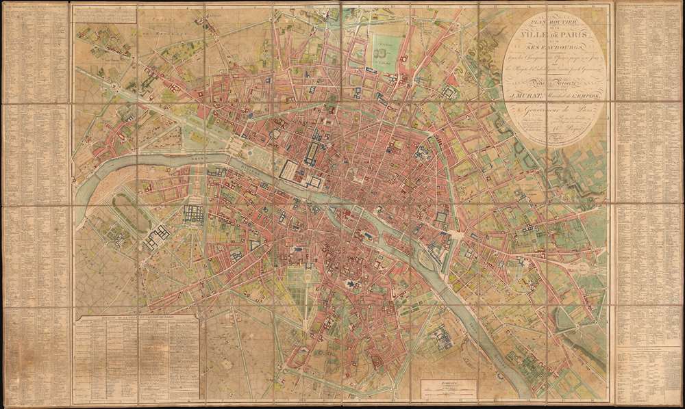
Plan Routier de la Ville de Paris et de ses Faubourgs, où se trouvent indiqués tous les Changements Opérés jusqu'à ce Jour avec les Projets d'Embellissement arrêtés par le Gouvernement.
1808 (dated) 33 x 55.25 in (83.82 x 140.335 cm) 1 : 7500
1808 (dated) 33 x 55.25 in (83.82 x 140.335 cm) 1 : 7500
Description
This stunning large-format folding 1808 Charles Picquet case map of Paris presents the city during the heady years of the Napoleonic era. Depicting the city from the newly-constructed Pont d'Jena (now the Pont d'Iéna) and the Champs de Mars to the Place du Trône and from Montmartre (then a small hamlet outside Paris) to the Porte d'Italie, the splendor and luxury of Napoleon's imperial capital are on full display.
Paris under the First Empire
Many sites that modern visitors will recognize, such as the Louvre, the Jardin des Tuileries, and Notre Dame are illustrated, as are the Place Vendôme and the Place de la Concorde, which only a few years earlier was bathed in blood by the French Revolution and their famous guillotine. Other sites immediately render apparent the contemporary political climate in Paris. For example, the Tuileries Palace is labeled as the Palais Impérial ou des Tuileries, and Les Invalides, famous for its gold dome, is known as the Hôtel Impérial des Invalides. Today's Quai d'Orsay, where millions visit the Musée d'Orsay every year, is labeled here as the Quai Bonaparte. Today's Place de l'Étoile is labeled here as the Étoile des Champs Elysées and is where Napoleon's Arc de Triomphe was being built to celebrate his victory at the Battle of Austerliz.The Remarkable Piquet Family
The Picquet's were remarkable in their tenacity with which they maintained and grew their government sponsored publishing contracts throughout the French Revolution, the Napoleonic Era, and the Bourbon Restoration. Early editions were dedicated to Joachim Murat, Marshal of the Empire and brother-in-law to the Emperor Napoleon I. After the fall of Napoleon, Picquet reworked the dedication to honor the Duc D'Orleans and the King of France, at the time Louis Philippe I.Publication History and Census
This map was created, engraved, and published by Charles Picquet in 1808. Six examples are catalogued in the OCLC and are part of the institutional collections at the Hagley Museum and Library in Wilmington, Delaware; the Thomas Fisher Rare Book Library in Toronto, Ontario, Canada; the University of Chicago; the Bibliothèque nationale de France in Paris, France; the Institut national d'histoire de l'art also in Paris; and the Bibliothèque nationale et universitaire in Strasbourg, France.Cartographer
Charles Picquet (April 15, 1771 – January 15, 1827) was a French cartographer active in Paris during the Napoleonic and post-Napoleonic Eras. Picquet was born in Romagna-sous-Montfaucon, Meuse, France. From about 1798 Picquet supplied maps to the Dépôt de la Guerre. From 1806 he was appointed to Napoleon's Cabinet Topographique. Being politically dexterous, he was able to retain this position after the fall of Napoleon under both Louis XVIII and Charles X. Under Louis XVIII he also obtained the Brevet de Géographe Ordinaire du Cabinet Topographique. He worked with the cartographer Adrien-Hubert Brué on a major atlas project. When Charles Picquet died in 1827, his son, Pierre-Jacques Picquet, continued to publish under his father's imprint name well into the middle part of the 19th century. More by this mapmaker...
Condition
Good. Dissected and mounted on original linen in 40 panels. Even overall toning. Exhibits some soiling.
References
OCLC 43857390.