This item has been sold, but you can get on the Waitlist to be notified if another example becomes available, or purchase a digital scan.
1889 Vuillemin Map of Paris, France
Paris-vuillemin-1889$225.00

Title
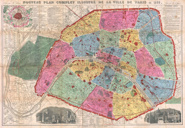
Nouveau Plan Complet Illustre de la Ville de Paris en 1889.
1889 (dated) 24 x 34 in (60.96 x 86.36 cm)
1889 (dated) 24 x 34 in (60.96 x 86.36 cm)
Description
A bright and stunning map of Paris made by A. Vuillemin for the 1889 Exposition Universelle (World's Fair). Covers the walled center of Paris as well as its immediate vicinity to the west, including the Bois de Boulogne. Important buildings are noted throughout and often shown in profile. The park where the 1880 Exposition Universelle was held, called the Champ de Mars, is noted. At the western end of the Champ de Mars, the Eiffel Tower is also noted as 'Tour Eiffel 300 Meters.' It is actually 324 meters. The Eiffel Tower was built to be the entry arch to the 1889 Exposition. That the Eiffel Tower is not drawn in profile, as are so many of Paris' great monuments, is a curious reminder that, at the time, the iconic structure was considered an eyesore. The lower right and left quadrants feature architectural views that include many of Paris' most notable buildings out of context. Indexes scattered around the map indentify theaters, libraries, museums, railroad lines and 'curiosities.' All text in French. Color coded by arrondissement. Drawn by A. Vuillemin and engraved by Charles Dyonnet for publication by A. Bes and F. Dubreuil.
CartographerS
Alexandre Aimé Vuillemin (1812 - 1880) was an engraver, publisher, and editor based in Paris, France in the middle of the 19th century. Despite a prolific publishing career, much of Vuillemin's life is shrouded in mystery. In 1852, he married Josephine Caroline Goret and they had at least one child, Ernestine Adèle Vuillemin, later in the same year. What is known is that his studied under the prominent French Auguste Henri Dufour (1798 - 1865). Vuillemin's most important work his detailed, highly decorative large format Atlas Illustre de Geographie Commerciale et Industrielle. More by this mapmaker...
Charles Dyonnet (fl. c. 1822 - c. 1880) was an extremely active Paris based engraver working in the mid to late 19th century. From his offices at 220 Rue St. Jacques, Paris, Dyonnet engraved numerous maps for many of the most prominent 19th French cartographic publishers including Vuillemin, Dufour, Fremin and Duvotenay. From 1850-1861, he held the coveted position of "Graveur du Dépot de la Marine," and in this position engraved numerous French naval and military maps. Dyonnet had a detail oriented and aesthetically minded hand and is responsible from some of the most beautiful French maps to emerge during the 19th century. Learn More...
Condition
Very good. Original folds exhibit some wear and verso repairs, especially at fold intersections. Folds into original red cardboard booklet.