This item has been sold, but you can get on the Waitlist to be notified if another example becomes available, or purchase a digital scan.
1815 / 1841 Collin Map of Paris w/ Manuscript of Thiers Wall by Gen. Doguereau
ParisDoguereau-collin-1815$2,500.00


Title
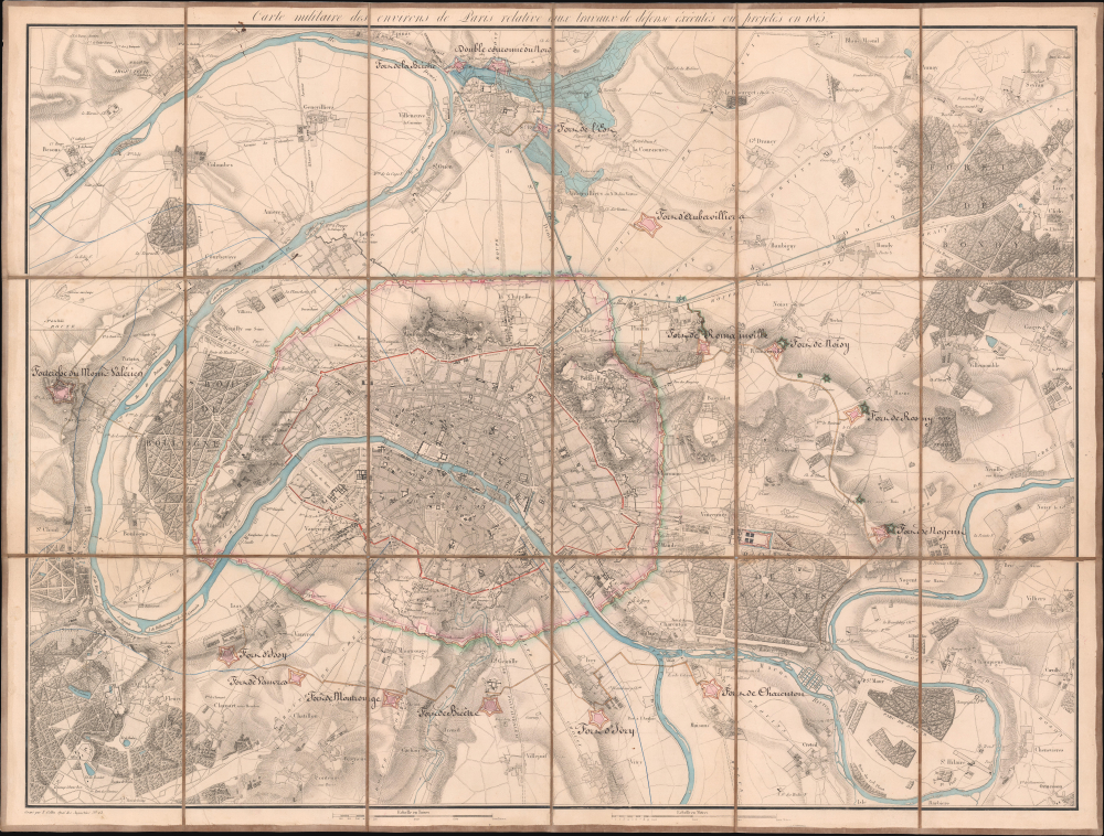
Carte Militaire des Environs de Paris relative aux traveaux de défense éxécutés ou projetés en 1815.
1815 (dated) 27.25 x 36 in (69.215 x 91.44 cm) 1 : 30000
1815 (dated) 27.25 x 36 in (69.215 x 91.44 cm) 1 : 30000
Description
This is a unique c. 1815 Charles-Étienne Collin map of Paris, France, with unique c. 1841 manuscript updates by General Louis Doguereau illustrating the planned fortification of Paris or, as it became known, the Thiers Wall (Enceinte de Thiers), one of the greatest follies of military engineering ever conceived. As head of the École d'Application de l'Artillerie et du Génie, Doguereau was part of the 8-man Commission des Fortifications organized to design the wall in 1840-41.
A Closer Look
This is a meticulously detailed medium-format map of Paris and environs, covering from St. Denis to Villejuif and from St. Cloud to Villiers. Paris dominates the map with a pre-Hausmann street configuration. Expertly executed pen and ink manuscript with watercolor wash illustrates the planned defensive structures, including the wall itself and the surrounding perimeter fortifications, each outlined and named. The manuscript work was likely added to the 1815 map in 1841, when construction on the fortifications, which transformed Parisian urban space, began in earnest.The 'Embastillement' of Paris
Shocked by the seizure of Paris by foreign enemies during the 1814 Battle of Paris, French King Louis-Philippe (1830 - 1848), conceived of a broad network of walls and forts he believed would make Paris impregnable. The project was met with immediate opposition, some of which claimed that the walls were not defensive but intended to control Parisians in the event of an anti-monarchal rebellion - hence our term embastillement, suggestive of both defense and imprisonment. Nonetheless, under a plan prepared by the Commission des Fortifications and Marshal General Jean-de-Dieu Soult (1759 - 1861), construction began in 1841. The completed fortifications, named the Thiers Wall after the French Prime Minister at the time, Adolphe Thiers (1797 - 1877), were, at enormous expense, completed in 1844. The walls were 33 kilometers long and consisted of 94 bastions, 17 gates, 23 minor road crossings, and 8 railroad gates. By 1919, advancements in military technology made the walls obsolete, leading them to be fully deconstructed by 1929 and replaced with the Boulevard Périphérique.Provenance: Louis Doguereau
Louis Doguereau's name is handwritten on the verso of the map, which was acquired with several other lesser maps from his estate. Doguereau (July 12, 1777 - August 19, 1856) was a French nobleman, general, and military officer active in the first half of the 19th century. He was born in Dreux, France, the son of Jean Pierre Parfait Doguereau, a master wigmaker. He entered the École de l'Artillerie in 1794, after which he served with valor in the Napoleonic Wars (1803 - 1815). During the Second Restoration (1815 - 1830), he was promoted to General and placed at the head of the École d'Application de l'Artillerie et du Génie. In 1840, he was part of the commission that designed the Thiers Wall, along with Adolphe Billault (1805 - 1863), General Thomas Robert Bugeaud (1784 - 1849), Mathieu de la Redorte, Allard, Liadière, General Odilon Barrot (1791 - 1873), and Bertin (likely Louis-François; 1766 - 1841).Publication History and Census
This map was engraved and published in 1815 by Charles-Étienne Collin and the Dépôt Général de la Guerre based on military surveys following the July 1815 occupation of Paris following the War of the Seventh Coalition, which finally defeated Napoleon and sent him into exile in St. Helena. The plates for this map survived, and restrikes were issued as late as 1975, that issue representing most surviving copies in institutional collections. The present c. 1815 example features unique manuscript updates likely dating to 1841, reflecting the final plans for the Thiers Wall. The map features remarkable provenance connecting it to General Louis Doguereau, who was involved in the commission that originally planned the wall. As a military engineer at the École d'Application de l'Artillerie et du Génie, it is reasonable that the manuscript annotations and additions are in Doguereau's own hand. Of the original 1815 printing, as here, we see only 2 examples in OCLC: Bibliothèque Nationale de France and Württembergische Landesbibliothek. The present example, with its important manuscript annotation, is unique.CartographerS
Charles-Étienne Collin (1770 - 1840) was a French engraver active in Paris during the late 18th and early 19th centuries. Collin was born in Paris to a long line of important French engravers dating back to Jean Collin. He was the son of Bernard Collin (1737 - 1791), son of Jean. Collin engraved for the seminal 1809 - 1822 Description de l'Egypte and extensively for the Dépôt de la Marine. His was contracted by his cousin by marriage, Phillipe Buache (February 7, 1700 - January 24, 1773) for his exceptional engraving mastery to work for the Dépôt de la Marine from at least August 1793. He worked with his brother, Jean-Louis Collin (1775 - 1858), from 1800 to 1803. His son, also Charles-Étienne Collin or possibly just Étienne Collin II (1790 - 1852), apprenticed under him and worked with him from 1821 to 1829. Under Charles-Étienne Collin (1770 - 1840) and then his son, the firm was located in Paris at N° 45, Rue de la Harpe. The last known work attributed to 'E. Collin' appeared in 1831. Distinguishing between the 'Collin' family of engravers on Dépôt de la Marine is difficult. The elder Étienne Collin (1770 - 1840) typically signed his work 'E. Collin' or later 'E. Collin père'. His son signs some of his work as 'E. Collin' and others as 'C.E. Collin fils.' There is some evidence of another generation of Collin engravers, also Charles-Étienne Collin, signing his work as 'C. E. Collin' between 1840 and 1875. More by this mapmaker...
Depot de Guerre (1688 - 1887) was a branch of the French military devoted to creating, collecting, and publishing military memoirs, plans, and maps. The Depot was founded in 1688 by Francois Michel le Tellier, the Marquis de Louvois. Louvois held the post of Secretary of State for War under Louis XIV and his best known for composing the first letter regarding the mysterious "Man in the Iron Mask". During the French Revolution and the Napoleonic Wars the Depot de Guerre expanded its operations to include any and all topographical research in France. In 1887 the Depot de Guerre was disbanded and its duties split between the Institut Geographique National (IGN) and the Service Historique de L'Armee (SHA). Learn More...
Condition
Excellent. Manuscript annotation and updates. Original linen backing stable.
References
Bibliothèque nationale de France, département Cartes et plans, GE C-3787. Hamel, G., Histoire de France depuis la révolution jusqu'à la chute du second empire, vol 5, page 273.