This item has been sold, but you can get on the Waitlist to be notified if another example becomes available, or purchase a digital scan.
1889 Bourdon Panoramic Map of Paris and Environs, Seen from the Eiffel Tower
ParisEiffel-bourdon-1889$475.00


Title
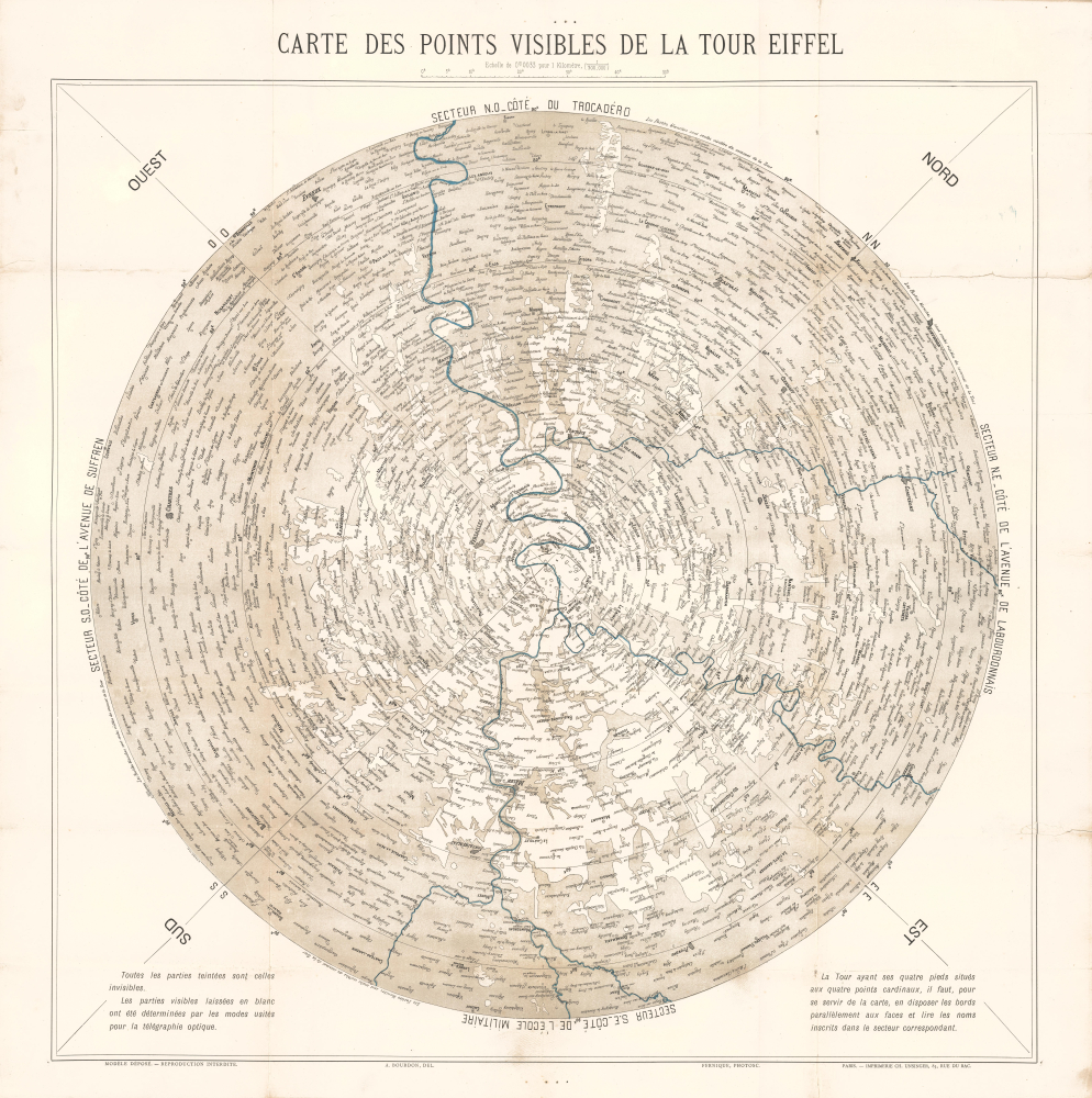
Carte des points visibles de la Tour Eiffel.
1889 (undated) 29.5 x 29.5 in (74.93 x 74.93 cm) 1 : 300000
1889 (undated) 29.5 x 29.5 in (74.93 x 74.93 cm) 1 : 300000
Description
This is A. Bourdon's unusual c. 1889 map of Paris and environs as viewed from the top of the Eiffel Tower. It was created for the 1889 Exposition Universelle, where the Eiffel Tower was formally unveiled.
The Seine and Marne Rivers flow through the map, connecting the four perspectives. The Thiers Wall seen here surrounding Paris was demolished in the 1920s as modern weapons made it obsolete.
A Closer Look
The map is centered on the Eiffel Tower in central Paris and divided into four sections, displaying a 360-degree perspective of Paris and its surrounding region. Since the tower's four feet are set at the cardinal directions, the sides face towards the northwest, northeast, southeast, and southwest. The top of the sheet corresponds to the northwest side of the tower, in the direction of the Trocadéro, across the Seine River from the Eiffel Tower. Areas that are tinted are not visible, either due to distance or due to buildings, trees, and hills blocking the view, while areas that are shaded white are those that can only be seen from the summit of the tower. The directions given at the bottom indicate that this map was meant to be carried up the tower and used as a viewing key.The Seine and Marne Rivers flow through the map, connecting the four perspectives. The Thiers Wall seen here surrounding Paris was demolished in the 1920s as modern weapons made it obsolete.
The Eiffel Tower
The Eiffel Tower was constructed as the centerpiece of the 1889 Exposition Universelle (World's Fair) in Paris, held to commemorate the 100th anniversary of the French Revolution. The iron lattice tower, designed by engineer Gustave Eiffel (1832 - 1923), was built between 1887 and 1889. At 300 meters tall, it was the tallest man-made structure in the world at the time and symbolized modern industrial progress. The tower famously met with mixed reviews during its construction, but went on to become the fair's main attraction and a lasting international icon of both Paris and France.The 1889 Exposition Universelle
Held in Paris, France, from May 5 through October 31, 1889, the Exposition was the fourth World's Fair held in Paris. It witnessed the unveiling of the Eiffel Tower, which was, then as now, a marvel of engineering. The fair welcomed over 32,000,000 visitors and took place on the Champ de Mars, the parade ground in front of the École Militaire. Other notable structures include the Gallery of Machines, a hall dedicated to science and technology (where some of Thomas Edison's most recent inventions were exhibited), and the Palaces of Liberal Arts and Fine Arts.Publication History and Census
This map was prepared by A. Bourdon with photographic assistance carried out by Fernique and was printed by the Imprimerie Charles Unsinger in Paris. (We have been unable to find the full name or further information on either Bourdon or Fernique.) It is undated, but all indications suggest that it was produced for visitors to the 1889 Exposition Universelle. This map is rare, being noted among the holdings of 7 institutions in the OCLC: Stanford University, the University of Chicago, the Centre Canadien d'Architecture, the Universiteit van Amsterdam, the Bibliothèque nationale de France, the Universitätsbibliothek Basel, and the State Library of Victoria.Cartographer
Charles Unsinger (June 11, 1823 - March 7, 1891) was a French printer and typographer. He was born in Strasbourg and apprenticed under the printer Gustave Silbermann, who sent him to Paris in 1851. There, Unsinger worked as a proofreader at the publisher Plon. From 1867 to 1871, he managed the Berger-Levrault printing workshops in Metz and Nancy. Returning to Paris in 1873, he took over the management of Jules Claye's machine workshops. In 1877, upon Claye's retirement, he set up his own business on the Rue du Bac and was assisted by his son-in-law Frédéric Emile Kapp (1851 - 193?), who also had his own firm specializing in letterpress and chromolithography. More by this mapmaker...
Condition
Good. Wear and some splits along old fold lines. Large split, from left side, upper right corner, stabilized on verso. Verso archival tissue repairs to weak points.
References
OCLC 57306060, 494648928.