This item has been sold, but you can get on the Waitlist to be notified if another example becomes available, or purchase a digital scan.
1572 Braun and Hogenberg View / Map of Paris, France
ParisLutetia-braunhogenberg-1572$1,750.00

Title
Lutetia vulgari Nomine Paris, Urbs Galliae Maxima, Sequana Navigabili Flumine Irrigatur ...
1572 (undated) 15 x 20 in (38.1 x 50.8 cm) 1 : 10000
1572 (undated) 15 x 20 in (38.1 x 50.8 cm) 1 : 10000
Description
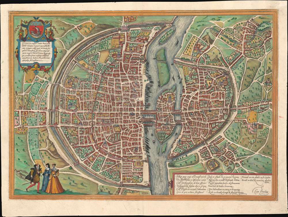
A fine full-color example of the Braun and Hogenberg's 1572 map and view of Paris, France. With the Seine flowing at center around the Île de la Cité, this view looks on Paris from the northwest, with the top of the map oriented to the southeast. The city is presented on from equidistant bird's-eye perspective wherein all structures are rendered in view form but from a uniform height and angle relative to all individual points. Fertile fields surround the city, and the rivers bustles with boats, suggesting richness and prosperity. In the bottom left corner, a man greets two women, all are wearing clothing corresponding to the Spanish influenced fashion norms of 1560 - 1570. The Bastille, an infamous as a prison prior to the French Revolution, appears here at top center, surrounded by a mat. The 1550 bastion, appearing to the left of the main structure of the Bastille is also evident. The map's title 'Lutetia' refers to the roman name for Paris which, by the 16th century, had largely been phased out.
Braun's Description of Paris
Text un the cartouche, below the title,Lutetia, commonly known as Paris, is the largest city in France and has the navigable Seine flowing around it. With the nobility, merchants, an excellent university, the stupendous church of Notre-Dame, the royal palace and other outstanding buildings, with a fair judiciary and most beautiful epitaphs, it is a most flourishing city.Text on the verso includes Georg Braun's description of Paris,
Paris is the capital of the most highly productive Kingdom of France, on account of its incredible size, the nobility, merchants and burghers, its number of students and its notable buildings. The city that lies between the University and the main town is connected to the University by two bridges and to the town proper by three, lined on both sides with houses. On this spot Philip the Fair built a royal palace, containing a little chapel constructed with wonderful skill. Here also is a magnificent church dedicated to Our Lady, which is considered a wonder of the whole of France on account of its wonderfully beautiful form, size and artistically skillful pictures.While Braun's description describes Paris in the late 16th century, at a time when the population was nearly 200,000 and an era of exceptional prosperity, under Henry IV (1553 - 1610), was about to begin, the map itself is in fact representative of an earlier era, c. 1530.
The Source Map or the 'Plan Premier'
This map is derived from a manuscript map of Paris known as the Plan Premier or 'First Plan' of Paris. Compiled between 1523 and 1530, the Plan Premier is said to have measured some 5 x 4 meters and is the source for most 16th century maps of Paris. The Plan Premier was kept in city offices and regularly to reflect urban development. Of the 7 city views of Paris issued in the 16th century, including this maps and Munster's similar view, all are derived from the Plan Premier. Curiously, the Plan Premier went missing in the late 16th century, so this and the other views are the only surviving record of this great map.Publication History and Census
This map appeared with few changes in various editions of Braun and Hogenberg's Civitates Orbis Terrarum , volume 1, issued between 1572 and 1623. The engraving is the work of Franz Hogenberg and the descriptive text complied by Georg Braun. The French language text on the verso suggests actual print date of about 1575.CartographerS
Georg Braun (1541 – March 10, 1622) was a German deacon, viewmaker, and typo-geographer based in Cologne. Along with Franz Hogenberg (1535 - 1590), Braun is best known for his publication of the highly influential city atlas Civitates Orbis Terrarum. The six volume work, with some 546 views, was published between 1572 and 1617 and intended a companion to Abraham Ortelius' Theatrum Orbis Terrarum - thus certain obvious stylistic similarities. In compiling the Civitates Braun took on the role of editor while most of the engraving work was completed by Franz Hogenberg. Braun died, as he was born, in Cologne. More by this mapmaker...
Franz Hogenberg (1535 - 1590), often called 'Master Franz,' was a Flemish engraver active in the late 16th century. Hogenberg was born in Mechelen, the son of Nicolas Hogenberg, where he trained under the cartographer H. Terbruggen. He later relocated to Antwerp where he achieved success as an engraver, working with Abraham Ortelius, Hieronymus Cock, and others. In 1568, his name appeared on the list of those banned from the Netherlands by the Duke of Alva, forcing his family to flee to London. There he engraved for Christopher Saxon's Atlas of England and Wales. By 1570 he emigrated to Germany settling in Cologne. In Cologne he married his second wife, Agnes Lomar, with whom he had six children. In 1579 the couple were briefly imprisoned for holding illicit secret religious meetings, but were released in short order. Along with German cleric George Braun (1541 – March 10, 1622), Hogenberg issued the highly influential city atlas Civitates Orbis Terrarum. The six volume work, with some 546 views, was published between 1572 and 1617 and intended a companion to Abraham Ortelius' Thatrum Orbis Terrarum - thus certain obvious stylistic similarities. In compiling the Civitates Hogenberg took on the role of engraver while most of the editing was left to Georg Braun. Hogenberg died in Cologne, Germany, before the Civitates was completed. After his death, Hogenberg's work was continued by his son, Abraham Hogenberg, who, under the direction of Agnes, his mother, took over his father's enterprise at just 20. Learn More...
Source
Braun, G. and Hogenberg, F., Civitates Orbis Terrarum. (Antwerp) 1575.
The Civitatus Orbis Terrarum is an 6-volume atlas of cities, or town book, compiled and written by George Braun, Canon of Cologne Cathedral and Franz Hogenberg. Braun and Hogenberg gathered together vast amounts of information and draft plans to produce over 500 city views/maps published in six parts between 1572 and 1617. Most of the town views and plans were engraved by Simon van den Neuvel (Novellanus) and Frans Hogenberg, many after drawings by Joris Hoefnagel. The Civitatus Orbis Terrarum was printed in Cologne, but in the Flemish style after Abraham Ortelius, the preeminent cartographer of the period. The text throughout is the work of Braun. The work proved to be a great success, reflecting the period's greater fascination with notable metropolises than with national boundaries. After the initial publication of volume 1, the popularity of the led to a second volume. In the introduction to volume 2, Braun requests that those who live in cities not represented, sent details of their own metropolises. This led to the publication of volumes 3, 4, and 5. Volume 6, the last, did not appear until 1617 under Franz Hogenberg's son, Abraham Hogenberg. The volumes include
- Civitates orbis terrarium, first edition 1572.
- De praecipuis, totius universi urbibus, liber secundus, first edition 1575.
- Urbium praecipuarum totius mundi, liber tertius, first edition 1581.
- Urbium praecipuarum totius mundi, liber quartus, first edition 1588.
- Urbium praecipuarum mundi theatrum quintum, first edition 1596.
- Theatri praecipuarum totius mundi urbium liber sextus, first edition 1617.
Condition
Very good. Full margins. Original centerfold.
References
Van der Krogt 4, 3298. Boutier, J. Les Plans de Paris, #15.