1840 S.D.U.K. Subscriber's Edition Map or Plan of Parma, Italy
Parma-sduk-1840$200.00

Title
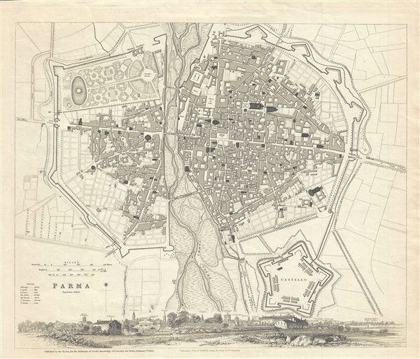
Parma.
1840 (dated) 13.5 x 15.5 in (34.29 x 39.37 cm) 1 : 8000
1840 (dated) 13.5 x 15.5 in (34.29 x 39.37 cm) 1 : 8000
Description
This is a scarce 1840 first edition map or city plan of Parma, Italy, published by the Society for the Diffusion of Useful Knowledge. The map covers the Italian city of Parma divided into two parts by the Parma River. It depicts the fortified city in detail, noting individual streets, important buildings, monuments, gates, bridges and parks. The Castello or Citadel of Parma and the Palazzo Giardino are also identified.
Parma, in the Emilia-Romagna region of Italy, is famous for its prosciutto (ham), cheese and magnificent countryside. A beautiful panoramic view along the bottom of the map features Parma as seen from the Gate of Santa Barnaba.
This map was part of A Series of Maps, Modern and Ancient, issued by subscription by the SDUK. Each folder in the series would contain a set of two maps bound together. The map accompanying this folder, not included here, was of New York City. Original folder included the names of committee members of the ‘Society’, a list of maps already published, the folder number, which is this case was LXXXII, the contents and the printer and publication details. This map was engraved and printed by J. Henshall and William Clowes and Sons and issued by the Society for the Diffusion of Useful Knowledge on Feb 1, 1840 for publication in their Feb 17, 1840 subscriber’s edition folder. The folder at the time was priced at 1 shilling plain or 1 shilling 6 pence colored. This map was later issued in the S.D.U.K. Atlas which was appeared in several editions from about 1844 well into to the 1850s.
Cartographer
The "Society for the Diffusion of Useful Knowledge" (1826 - 1848) was a Whiggish organization founded in 1828 at the instigation of idealistic British lord Henry Peter Brougham. The admirable goal of the Society was to distribute useful information via a series of publications to the English working and middle classes. It promoted self-education and the egalitarian sharing of all knowledge. While closely tied to the London University and publishing houses on the order of Baldwin and Cradock, Chapman and Hall, and Charles Knight, the Society failed to achieve its many lofty goals in finally closed its doors in 1848. Most likely the failure of the Society resulted from its publications being too expensive for its intended lower to middle class markets and yet not large and fine enough to appeal to the aristocratic market. Nonetheless, it did manage to publish several extraordinary atlases of impressive detail and sophistication. Their most prominent atlas consisted of some 200 separately issued maps initially published by Baldwin and Cradock and sold by subscription from 1829 to 1844. Afterwards, the Society combined the maps into a single world atlas published under the Chapman and Hall imprint. In its day, this atlas was unprecedented in its quality, scope, and cost effectiveness. Today Society, or S.D.U.K. as it is commonly known, maps are among the most impressive examples of mid-19th century English mass market cartographic publishing available. The S.D.U.K. is especially known for its beautiful and accurately detailed city plans. More by this mapmaker...
Source
A Series of Maps, Modern and Ancient, Feb 17, 1840.
The Society for the Diffusion of Useful Knowledge (S.D.U.K.) Atlas was initially issued in parts over several years by Baldwin and Craddock to promote the society's mission of egalitarian self-education. The first S.D.U.K. began appearing in 1829 when the society contracted John Walker to produce the first proofs. The first S.D.U.K maps were produced serially by Baldwin and Craddock and issued in 2 map batches, priced at 2 shillings each. The series, originally anticipated to feature 50 maps, ultimately contained 200 and took over 14 years to produce. The initial production was completed in 1844 when the whole was issued in its first compiled atlas edition. Around 1842, following the 1837 bankruptcy of Baldwin and Craddock, publication of the atlas was taken over by the Society itself, who issued editions in 1838, 1839, 1840, 1841, and 1842. Overburdened by the work of publishing, they then outsourced the publication to Chapman and Hall in 1842. Chapman and Hall produced editions in 1842, 1843, and 1844. Dissatisfied with the quality of Chapman and Hall printing, the Society turned to another publisher, Charles Knight, who issued editions under the auspices of the Society in 1844, 1845, and 1846. In 1846 Knight officially acquired the plates in his own right and reissued in revised editions until 1852, when he sold them to George Cox. Cox in turn sold them to Edward Stanford who published them from 1856 well into the 1860s. The S.D.U.K. Atlas is known for the quantity and quality of its maps. The S.D.U.K. published many maps of areas largely ignored by other publishers. The many city plans incorporated into the atlas are particularly admired and are the highlight of the S.D.U.K.'s long map publishing history. As a whole the S.D.U.K. Atlas was groundbreaking in terms of quality, scope, and being offer at a cost effective price point.
Condition
Very good. Minor foxing. Original platemark visible.
References
Rumsey 0890.197 (atlas edition).