This item has been sold, but you can get on the Waitlist to be notified if another example becomes available, or purchase a digital scan.
1929 Cravens and Dargan Map of Hurricane Paths in the West Indies
PathsHurricanes-cravensdargan-1929$200.00

Title
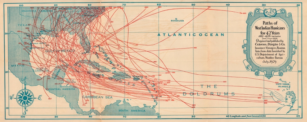
Paths of West Indian Hurricanes for 42 Years 1887 - 1928 inclusive (and June 1929).
1929 (dated) 12 x 30 in (30.48 x 76.2 cm)
1929 (dated) 12 x 30 in (30.48 x 76.2 cm)
Description
This is a July 1929 Cravens, Dargan and Company map of the West Indies highlighting hurricane paths. Dozens of storms are traced over the course of 42 years, from 1887 until 1928.
A Closer Look
Depicting the region from Mexico east to the Cape Verde Islands and from North Carolina south to northern South America, numerous red lines follow hurricane paths across the Atlantic and the Caribbean to landfall in the United States and Mexico. Each track is dated by year and follows the hurricane from formation to the map's border or, in the case of one hurricane from 1895, back out into the Atlantic.Publication History and Census
This map was created and published by Cravens, Dargan and Company in July 1929. 2 examples are cataloged in OCLC and are part of the collections at Baylor University and the University of Texas Rio Grande Valley.Condition
Good. Wear along original fold lines. Some areas of infill along fold lines. Some offsetting.
References
OCLC 1322467084, 986537740.