1756 Bellin / Depot de Marine Vexillology / Flag Chart
Pavillions-bellin-1756$1,800.00


Title
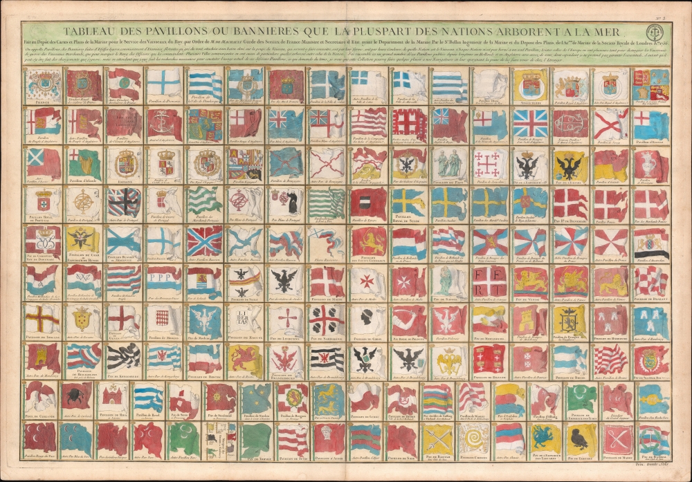
Tableau des Pavillons ou Bannieres Que La Pluspart des Nations Arborent a la Mer.
1756 (dated) 25.5 x 36.5 in (64.77 x 92.71 cm)
1756 (dated) 25.5 x 36.5 in (64.77 x 92.71 cm)
Description
This is an exceptional 1756 J. N. Bellin / Dépôt de la Marine vexillology or flag chart illustrating worldwide maritime ensigns. It illustrates a total of 160 flags, most representing European powers, but some representing religious societies, Asian and African nations, and trading companies.
Trading Ensigns
Trading companies represented include the VOC (Verenigde Oostindische Compagnie) or Dutch East India Company. Here, the 'V' in the company logo is erroneously engraved as an 'A.' Also noted is the GWC (Geoctrooieerde Westindische Compagnie) or Dutch West India Company. Although both houses were once global powerhouses, leveraging enormous wealth and large private armies, by the time this chart was issued, they were near the end of a long period of decline. Both lasted until the Fourth Anglo-Dutch War (1780 - 1784), after which they were dissolved and nationalized by the Batavian Republic.Flags of the Tartars
Another item of exceptional interest is the two flags of the Tartars in the lower right - one bearing a dragon (or griffin), the other an owl, both against a yellow field. These flags first appeared in the Carl Allard flag chart of 1694 and were copied by many subsequent charts. Little is known of their origins. The chart suggests that the dragon or griffin represents the Tartar Emperor, the Khan himself, while the owl is a general flag for the Tartar Khanates. At the time, there were many Tartar Khanates. The dragon may refer to Zilant, a legendary creature commonly associated with the Kazan Khanate. However, the Kazan Khanate was landlocked and is unlikely to have ever fielded a navy, leading to further speculation that the flag refers to the Crimean Khanate (1441 - 1783), which maintained a Black Sea fleet. The owl figure on the second Tartar flag is even more mysterious. Allard posits it as an alternative 'Tartar' flag, but other than Allard derivates, we can find no reference to it.Publication History and Census
This chart was compiled by Jacques Nicholas Bellin and published by the Dépôt des Cartes et Plans de la Marine, a French mapping agency similar to the U.S. Coast Survey or British Admiralty. It was issued both for separate sale and for inclusion in French nautical atlases. The map is quite rare. We note examples only at the Universitäts- und Landesbibliothek Düsseldorf and Bibliothèque nationale de France. We also note at least two examples that have appeared privately in the late 20 years.CartographerS
Jacques-Nicolas Bellin (1703 - March 21, 1772) was one of the most important cartographers of the 18th century. With a career spanning some 50 years, Bellin is best understood as geographe de cabinet and transitional mapmaker spanning the gap between 18th and early-19th century cartographic styles. His long career as Hydrographer and Ingénieur Hydrographe at the French Dépôt des cartes et plans de la Marine resulted in hundreds of high quality nautical charts of practically everywhere in the world. A true child of the Enlightenment Era, Bellin's work focuses on function and accuracy tending in the process to be less decorative than the earlier 17th and 18th century cartographic work. Unlike many of his contemporaries, Bellin was always careful to cite his references and his scholarly corpus consists of over 1400 articles on geography prepared for Diderot's Encyclopedie. Bellin, despite his extraordinary success, may not have enjoyed his work, which is described as "long, unpleasant, and hard." In addition to numerous maps and charts published during his lifetime, many of Bellin's maps were updated (or not) and published posthumously. He was succeeded as Ingénieur Hydrographe by his student, also a prolific and influential cartographer, Rigobert Bonne. More by this mapmaker...
Dépôt des Cartes et Plans de la Marine (fl. 1720 - present), often called the Dépôt de Marine, was a French hydrographic mapping organization founded in 1720 under Charles-Hercule of Albert de Luynes (1674 - 1734). Much like the U.S. Coast Survey, the British Admiralty, and the Spanish Deposito Hydrografico, the Dépôt was initiated as a storehouse and distribution center of existing nautical and marine charts. Eventually the Dépôt initiated its own mapping activities in an attempt to improve and expand upon existing material. Some of the more prominent cartographers and hydrographers associated with the of Dépôt des Cartes were, Philippe Buache, Jacques-Nicholas Bellin, Giovanni Rizzi-Zannoni, Rigobert Bonne, and Jean Nicolas Buache. Learn More...
Condition
Very good. Slight toning.
References
OCLC 693403856. Bibliothèque nationale de France, RESERVE QB-201 (171)-FT 5 [Hennin, 8827].