This item has been sold, but you can get on the Waitlist to be notified if another example becomes available, or purchase a digital scan.
1749 Vaugondy Map of Southern Africa
PaysdesCafres-vaugondy-1749$90.00

Title
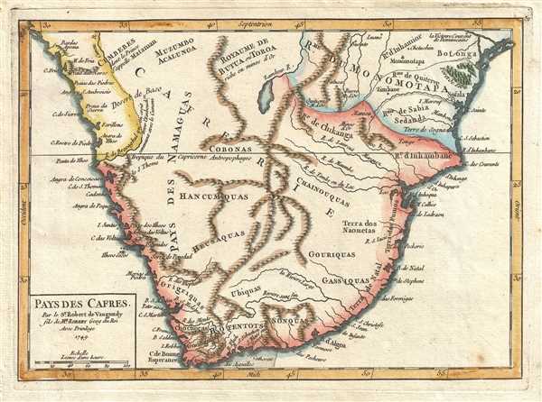
Pays des Cafres. Par le Sr. Robert de Vaugondy fils de Mr. Robert Geog du Roi.
1749 (dated) 6.5 x 9 in (16.51 x 22.86 cm) 1 : 13000000
1749 (dated) 6.5 x 9 in (16.51 x 22.86 cm) 1 : 13000000
Description
This is a hand colored 1749 Didier Robert de Vaugondy map of southern Africa. The map depicts the southern half to third of the continent of Africa pre-colonialism. Most the map is dominated by Cafrerie, a variation of the French word cafre. Used in southern Africa to refer to a black person, today the word is an offensive ethnic slur. Cafre is most likely derived from the Arabic work kafir meaning 'unbeliever' or 'non-Muslim' and was then adapted into Afrikaans by Dutch settlers. There are no regional divisions in this large expanse of land. Only tribal names are given, some of which are said to have 'country' ( pays des…). Mountain ranges and rivers snake across the open expanse of land, including the Zambeze River, and, near the Cape of Good Hope, a 'river without end (Riviere sans fin).
The Kingdom of Mutapa (Royaume de Monomotapa) is depicted. It existed from c. 1430 until 1760, when it disintegrated under a civil war. The 'winners' of the war governed a smaller kingdom until 1917 when the last king of the ruling dynasty was killed in battle against the Portuguese.
This map was published by Gilles Robert de Vaugondy in his Atlas Universel, Portatif et Militaire in the 1749 edition.
Cartographer
Robert de Vaugondy (fl. c. 1716 - 1786) was French may publishing from run by brothers Gilles (1688 - 1766) and Didier (c. 1723 - 1786) Robert de Vaugondy. They were map publishers, engravers, and cartographers active in Paris during the mid-18th century. The father and son team were the inheritors to the important Nicolas Sanson (1600 - 1667) cartographic firm whose stock supplied much of their initial material. Graduating from Sanson's maps, Gilles, and more particularly Didier, began to produce their own substantial corpus. The Vaugondys were well-respected for the detail and accuracy of their maps, for which they capitalized on the resources of 18th-century Paris to compile the most accurate and fantasy-free maps possible. The Vaugondys compiled each map based on their own geographic knowledge, scholarly research, journals of contemporary explorers and missionaries, and direct astronomical observation. Moreover, unlike many cartographers of this period, they took pains to reference their sources. Nevertheless, even in 18th-century Paris, geographical knowledge was limited - especially regarding those unexplored portions of the world, including the poles, the Pacific Northwest of America, and the interiors of Africa, Australia, and South America. In these areas, the Vaugondys, like their rivals De L'Isle and Buache, must be considered speculative or positivist geographers. Speculative geography was a genre of mapmaking that evolved in Europe, particularly Paris, in the middle to late 18th century. Cartographers in this genre would fill in unknown lands with theories based on their knowledge of cartography, personal geographical theories, and often dubious primary source material gathered by explorers. This approach, which attempted to use the known to validate the unknown, naturally engendered rivalries. Vaugondy's feuds with other cartographers, most specifically Phillipe Buache, resulted in numerous conflicting papers presented before the Academie des Sciences, of which both were members. The era of speculative cartography effectively ended with the late 18th-century explorations of Captain Cook, Jean Francois de Galaup de La Perouse, and George Vancouver. After Didier died, his maps were acquired by Jean-Baptiste Fortin, who in 1787 sold them to Charles-François Delamarche (1740 - 1817). While Delamarche prospered from the Vaugondy maps, he defrauded Vaugondy's window Marie Louise Rosalie Dangy of her rightful inheritance and may even have killed her. More by this mapmaker...
Source
Robert de Vaugondy, G., Atlas Portatif, Universel, et Militaire, (Paris: Vaugondy, Durand, Pissot) 1749.
Condition
Very good. Blank on verso. Original press mark visible.
References
Pedley, M. S., Bel et Utile, p. 207, 440. OCLC 159770046.