This item has been sold, but you can get on the Waitlist to be notified if another example becomes available, or purchase a digital scan.
1754 Bellin Map of the Cape of Good Hope and Part of South Africa
PaysHottentots-bellin-1754$100.00

Title
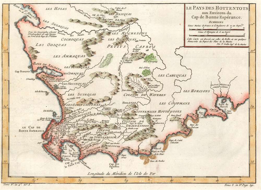
Le Pays des Hottentots aux Environs du Cap de Bonnes Espérance.
1754 (undated) 10.5 x 14.25 in (26.67 x 36.195 cm) 1 : 1400000
1754 (undated) 10.5 x 14.25 in (26.67 x 36.195 cm) 1 : 1400000
Description
This is a 1754 Jacques-Nicolas Bellin map of western South Africa. The map depicts the region from the Atlantic Ocean to Mossel Bay and from St. Helena Bay to Cape Agulhas. Several Dutch colonies are labeled near the coast, including Cape Colony, Stellenbosch Colony and Drakensteen Colony. Both Stellenbosch and Drakenstein are modern municipalities outside of Cape Town. In this region, rivers and mountains are labeled, as are settlements, and even a church near Stellenbosch. Outside these three colonies, areas are labeled by the tribe that lived there. These names, however, are not what the tribes called themselves. The words 'cafre' and 'hottentot' are both used here. Today, these words are recognized as deeply insulting and offensive racial slurs. In the 17th and 18th centuries the term 'Hottentots', today known as the Khoikhoi, were characterized by savagery and were often depicted as cannibals.
Publication History and Census
This map was created by Jacques-Nicolas Bellin in 1754 for inclusion in Abbé Prévost's Histoire Générale des Voyages.Cartographer
Jacques-Nicolas Bellin (1703 - March 21, 1772) was one of the most important cartographers of the 18th century. With a career spanning some 50 years, Bellin is best understood as geographe de cabinet and transitional mapmaker spanning the gap between 18th and early-19th century cartographic styles. His long career as Hydrographer and Ingénieur Hydrographe at the French Dépôt des cartes et plans de la Marine resulted in hundreds of high quality nautical charts of practically everywhere in the world. A true child of the Enlightenment Era, Bellin's work focuses on function and accuracy tending in the process to be less decorative than the earlier 17th and 18th century cartographic work. Unlike many of his contemporaries, Bellin was always careful to cite his references and his scholarly corpus consists of over 1400 articles on geography prepared for Diderot's Encyclopedie. Bellin, despite his extraordinary success, may not have enjoyed his work, which is described as "long, unpleasant, and hard." In addition to numerous maps and charts published during his lifetime, many of Bellin's maps were updated (or not) and published posthumously. He was succeeded as Ingénieur Hydrographe by his student, also a prolific and influential cartographer, Rigobert Bonne. More by this mapmaker...
Condition
Very good. Even overall toning. Tight left margin. Blank on verso.
References
OCLC 84299464.