1786 Huddart Map of the Pearl River, China: Hong Kong, Guangzhou
PearlRiver-huddart-1786$2,200.00

Title
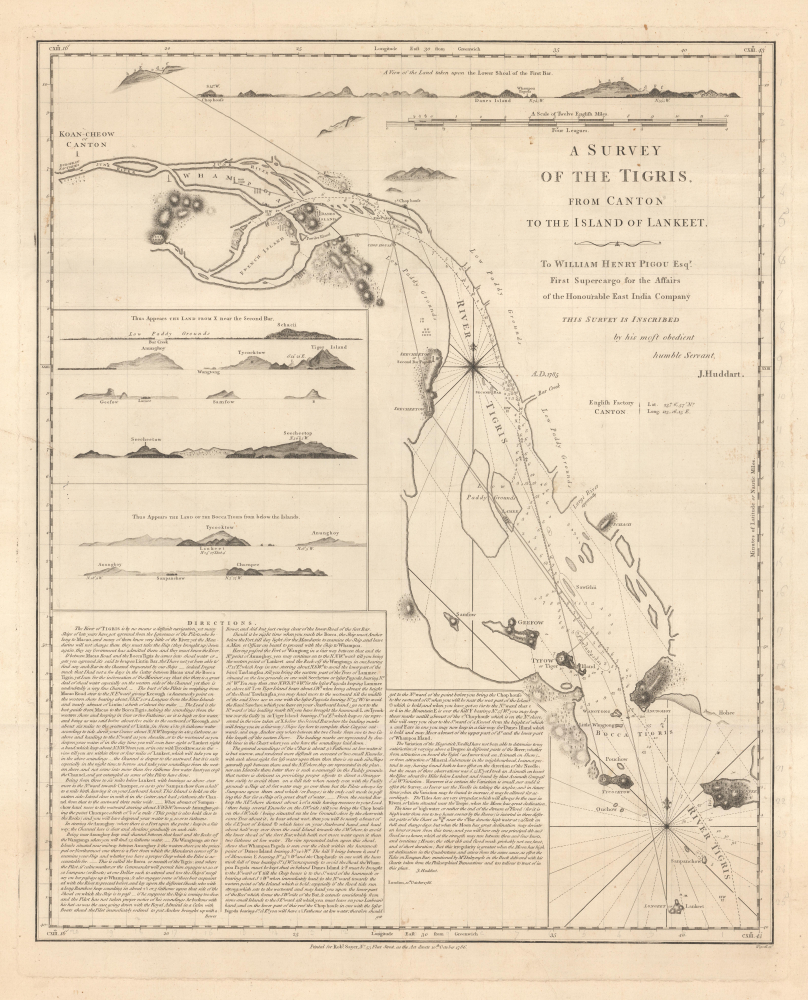
A Survey of hte Tigris, from Canton to the Island of Lankeet.
1786 (dated) 26.25 x 21.25 in (66.675 x 53.975 cm) 1 : 97000
1786 (dated) 26.25 x 21.25 in (66.675 x 53.975 cm) 1 : 97000
Description
This is Joseph Huddart's 1786 hydrographic map of the Pearl River, China. This rare chart is a result of novel 1785 surveys personally completed by Huddart, who was frustrated with the incompetence of for-hire Macanese Pearl River pilots.
A Closer Look
The map covers the Pearl River Estuary (Zhujiang River Estuary / 珠江三角洲) from roughly Canton (Guangzhou / 广州市) to Chuenpee (Tuen Muin / 屯門), in the western part of the Hong Kong New Territories and Shenzhen Bay (Deep Bay). The map includes several shore profiles, as well as extensive and detailed sailing instructions.A Human Navigational Hazard
In completing the survey and issuing this chart, Huddart was addressing an ongoing navigation problem in the Pearl River Delta - mandated Macanese pilots:The River of Tigris is by no means a difficult navigation, yet many Ships of late years have got aground from the Ignorance of the Pilots, who belong to Macao, and many of them know very little of the River: yet the Mandarins will not change them they must take the Ship (they brought up) down again, they say Government has admitted them and they must know the River.
Publication History and Census
This map was first published, as here, in 1786, by Robert Sayer based on the hydrography of Joseph Huddart. The present example is the first edition. A second edition was issued by Laurie and Whittle in 1794. All examples are scarce, especially on the private market. We see institutional holdings at the Bibliothèque Nationale de France, British Library, Hong Kong University of Science and Technology. Due to a proliferation of digital copies on OCLC, a complete census of institutional holdings is impossible.CartographerS
Joseph Huddart (January 11, 1741 - August 19, 1816) was a prominent English sea captain, hydrographer, chartmaker, inventor, and entrepreneur. Born into a fishing family in Allonby, near Maryport in Cumberland, he began his career at sea with his father as a fisherman. By 1762, he commanded the sloop Allonby, carrying cured fish to Ireland for the West Indian market. Later, he designed and built the first ship he would own privately, the Patience, launched in 1768 for the West Indies trade. In 1773, Huddart entered the service of the East India Company as Fourth Officer aboard the York, sailing to St. Helena and Bencoolen. During this voyage, he carried out extensive scientific surveys and observations along the western coast of Sumatra. His efforts came to public notice in 1777 when Robert Sayer published Huddart's charts of the Sumatran coastline and commissioned him to survey St. George's Channel, a project completed in the summer of 1778. The resulting chart, noted for its precision, secured his reputation as one of Britain's foremost hydrographers and ensured his financial success. Later, in 1777, he returned to the East India Company, where he rose to the position of Captain of the Royal Admiral. For nearly ten years, he sailed routes between India and China. In 1786, his chart of the Tigris (Pearl River, China) delta was issued by Robert Sayer. Huddart retired from active service in 1791 but continued to play a central role in maritime affairs. That same year, he was elected a Fellow of the Royal Society, and in 1798, he became one of the founding directors of the East India Dock Company, laying its first foundation stone in 1804. He also served for 25 years as one of the Elder Brethren of Trinity House, offering his expertise on harbor and dock improvements. His inventive work included the three-arm protractor used by hydrographers and a system for using high-water marks in the London docks - a method that remained in practice until the 1960s. Perhaps his most significant contribution to the maritime arts was the development of steam-powered machinery for rope-making, which he transformed into a highly profitable enterprise. More by this mapmaker...
Robert Sayer (1725 - January 29, 1794) was an important English map publisher and engraver active from the mid to late 18th century. Sayer was born in Sunderland, England, in 1725. He may have clerked as a young man with the Bank of England, but this is unclear. His brother, James Sayer, married Mary Overton, daughter-in-law of John Overton and widow of Philip Overton. Sayer initially worked under Mary Overton, but by December of 1748 was managing the Overton enterprise and gradually took it over, transitioning the plates to his own name. When Thomas Jefferys went bankrupt in 1766, Sayer offered financial assistance to help him stay in business and, in this way, acquired rights to many of the important Jefferys map plates as well as his unpublished research. From about 1774, he began publishing with his apprentice, John Bennett (fl. 1770 - 1784), as Sayer and Bennett, but the partnership was not formalized until 1777. Bennett retired in 1784 following a mental collapse and the imprint reverted to Robert Sayer. From 1790, Sayer added Robert Laurie and James Whittle to his enterprise, renaming the firm Robert Sayer and Company. Ultimately, Laurie and Whittle partnered to take over his firm. Sayer retired to Bath, where, after a long illness, he died. During most of his career, Sayer was based at 53 Fleet Street, London. His work is particularly significant for its publication of many British maps relating to the American Revolutionary War. Unlike many map makers of his generation, Sayer was a good businessman and left a personal fortune and great estate to his son, James Sayer, who never worked in the publishing business. Learn More...
George Wigzell (1753 - December 12, 1833) was an English engraver active in London in the late 18th and early 19th centuries. Wigzell was born in Greenwich to a poulterer. From 1769, he apprenticed under Joseph Ellis of the Stationer's Guild and joined the Guild in 1776. Wigzell engraved maps for Robert Sayer, Aaron Arrowsmith, John Stephenson, Laurie and Whittle, and others. His son, Thomas Wigzell (1791 - 1873), was also a map engraver. Learn More...
Condition
Very good. A few minor tears, stabilized on verso. Faint contemporary grid introduced in pencil - could be erased on request.
References
Hong Kong University of Science and Technology, G7822.C7 1786.H84. Bibliothèque Nationale de France, département Cartes et plans, GE SH 18 PF. OCLC 1007363791.