
1587 Bünting Map of Asia as Pegasus

This item has been sold.
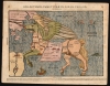
Asia Secunda Pars Terrae In Forma Pegasir.
Fascinating Allegorical Asia.
- Digital Map Information
- Suitable for large format printing
- Full resolution TIFF file
- ICC color profile embedded
- Delivered instantly via download link
Fascinating Allegorical Asia.
This is one of the most famous cartographic curiosities: Heinrich Bünting's 1587 map of Asia in the form of the mythological winged horse, Pegasus. The horse's head is Asia Minor; its front legs form the Arabian Peninsula. Persia resembles a horse blanket. The hind legs represent the Indian and Malay peninsulas, while the spreading wings cover the northern steppe of Scythia and Tartaria. This beautiful woodcut appeared in Bünting's Itinerarium Sacrae, the first and, for many years, the only complete work of biblical geography.Layered Meanings
While the mapping of Asia had advanced swiftly in the late 16th century, the present map is not at all a literal representation of contemporary geographical knowledge. Its purpose was metaphorical. The dramatic image referenced classic Greek myth: Pegasus was captured and tamed by the Greek hero Bellerophon, who then rode the winged horse into victorious battle against the three-headed, fire-breathing Chimera. Bünting proposed Bellerophon's defeat of the Chimera as a metaphor for Jesus defeating Satan. But he also considers Bellerophon's taming of Pegasus itself as a metaphor for 'Jesus Christ, that great Bellerophon, the slayer of all evil' having 'opened the fountain of learning in Asia'.Publication History and Census
This map is frequently found dated 1581, corresponding to the first Helmstadt edition of Bünting's Itinerarium. Scrutiny of editions of the work in institutional collections indicates that neither this map nor the accompanying map of Africa was introduced until either the 1587 or 1589 Magdeburg edition. Separate examples of the map speculatively dated earlier often exhibit typographical features that correspond with examples printed sometimes well into the 17th century. The incorrect dating of these appears to be influenced by the cataloging of Bünting's famous cloverleaf world map, which was included in the 1581 and 1582 Helmstadt editions. The Asia map would appear using at least two separate blocks (we see a 1598 edition, also Magdeburg, using a different block than this). The present 1587 block we see in no fewer than ten editions. This example most closely conforms but is not identical to the 1600 editions we have been able to confirm. The map has long been a justifiable favorite of collectors and has a record of appearances at auction and in dealers' catalogs, though attractive examples are becoming harder to source. Perhaps a dozen examples of the separate map appear in OCLC. The Itinerarium Sacrae Scripturae appears in many editions in institutional collections.Cartographer
Heinrich Bünting (1545 – 1606) was a Protestant pastor and theologian. He was born in Hanover, and studied theology at the University of Wittenberg. He earned his Master's degree in 1569. He remained in Wittenberg as a pastor there, before being appointed to that same position at Alt Calenberg, in the service of the Dukes of Saxony. The estate was dissolved when the marriage of the Duchess Sidona and Duke Eric the Younger foundered, and Bünting became pastor in Gronau in 1575. In Gronau, he wrote his two major works - the 1581 Itinerarium Sacrae Scripturae, and the 1584 Brunswick and Lüneburg Chronicle. He produced a smaller work on Biblical coins and measures in 1582. He would briefly serve as superintendent in Goslar, but he would be dismissed as a result of theological differences. Stung, he returned to his hometown and changed to the less controversial profession of a beer brewer, until his death in 1606. The work for which he is best known, Itinerarium Sacrae Scripturae, was the first complete summary of biblical geography. It remained in print in more than sixty editions, long after his death. Earlier editions contain some of the most distinctive and sought after maps, most notably his map of the world in the shape of a cloverleaf, and an allegorical map of Asia in the form of a Pegasus. Further Details...
Source
Bünting, Heinrich, Itinerarium Sacrae Scripturae, (Magdeburg) 1600.
Condition
Very good. Lightly toned, some marginal staining and reinforcement.
References
Tooley, R. Map Collectors' Circle No. 1 'Geographical Oddities,' no. 3. Suarez, T. The Mapping of Southeast Asia p.99. Yeo, J. Mapping the continent of Asia pp. 12-13.