This item has been sold, but you can get on the Waitlist to be notified if another example becomes available, or purchase a digital scan.
1690 Coronelli Map of Xantung (Shandong) and Peking (Hebei) Provinces, China
Peking-coronelli-1690$397.50

Title
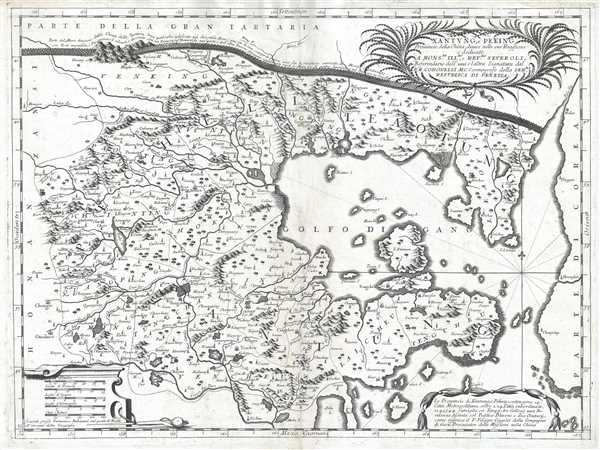
Xantung, e Peking Provincie della China, divise nelle sue Reggioni.
1690 (undated) 18.25 x 24.75 in (46.355 x 62.865 cm) 1 : 2000000
1690 (undated) 18.25 x 24.75 in (46.355 x 62.865 cm) 1 : 2000000
Description
This is a c. 1690 Vincenzo Maria Coronelli map of the Xantung (Shandong) and Peking (Hebei) provinces in China. The map depicts the region from Henan and Shanxi Provinces to the Korean Peninsula and from Inner Mongolia to Shandong Province. Highly detailed, numerous cities, towns, and villages are labeled throughout, including Beijing and Tianjin. An incredible rendering of the Great Wall of China traverses the top of the map and includes a caption giving some information about the Wall itself. Rivers, lakes are illustrated and labeled, including the Yalu River. Mountains and forests populate the countryside, and islands are depicted in the Bohai and Yellow Seas. A decorative title cartouche is situated in the upper right corner that includes a dedication to Severoli. A second decorative cartouche in the bottom right corner includes a short text about the region, and a third cartouche in the lower left corner houses the scales.
Coronelli most likely compiled this map from work by Joan Blaeu, and maps created by the Jesuit missionary Martinus Martini. Since the beginning of the 17th century, Jesuit missionaries had been exploring in China and forging relationships with the Chinese emperors and other elites. One way in which the missionaries gained favor was through their knowledge of astronomy, geography, and cartography. Both Blaeu and the Jesuit missionary Martinus Martini published maps of this region in the mid-17th century. Martini was the first European to publish maps of China in Europe since Marco Polo. Jean Baptiste Bourguignon d'Anville noted in his Mémoire that 'Martini made use of the maps which the Chinese possessed at the time.' By having access to Martini's and Blaeu's maps, Coronelli was able to update their maps with more inland detail.
This map was produced and published by Vincenzo Maria Coronelli in his Corso Geografico Universale c. 1690.
Cartographer
Vincenzo Maria Coronelli (August 16, 1650 - December 9, 1718) was an important 17th-century cartographer and globe maker based in Venice. Coronelli was born the fifth child of a Venetian tailor. Unlikely to inherit his father's business, he instead apprenticed in Ravenna to a woodcut artist. Around 1663, Coronelli joined the Franciscan Order and, in 1671, entered the Venetian convent of Saint Maria Gloriosa dei Frari. Coronelli excelled in the fields of cosmography, mathematics, and geography. Although his works include the phenomenal Atlante Veneto and Corso Geografico, Coronelli is best known for his globes. In 1678, Coronelli was commissioned to make his first major globes by Ranuccio II Farnese, Duke of Parma. Each superbly engraved globe was five feet in diameter. Louis IV of France, having heard of the magnificent Parma globes, invited Coronelli to Paris, where from 1681-83 he constructed an even more impressive pair of globes measuring over 12 feet in diameter and weighing 2 tons each. The globes earned him the patronage of Louis XIV and privileged access to French cartographic information from Jesuit sources in the New World, particularly Louisiana. Coronelli returned to Venice and continued to publish globes, maps, and atlases, which were admired all over Europe for their beauty, accuracy, and detail. He had a particular fascination for the Great Lakes region, and his early maps of this area were unsurpassed in accuracy for nearly 100 years after their initial publication. He is also well known for his groundbreaking publication of the first accurate map depicting the sources of the Blue Nile. At the height of his career, Coronelli founded the world's first geographical society, the Accademia Cosmografica degli Argonauti, and was awarded the official title Cosmographer of the Republic of Venice. In 1699, in recognition of his extraordinary accomplishment and scholarship, Coronelli was also appointed Father General of the Franciscan Order. The great cartographer and globe maker died in Venice at the age of 68. His extraordinary globes can be seen today at the Bibliothèque Nationale François Mitterrand in Paris, Biblioteca Marciana in Venice, the National Library of Austria, the Globe Museum in Vienna, the Library of Stift Melk, the Special Collections Library of Texas Tech University, as well as lesser works in Trier, Prague, London, and Washington D.C. Coronelli's work is notable for its distinctive style, which is characterized by the high-quality white paper, dark intense impressions, detailed renderings of topographical features in profile, and numerous cartographic innovations. More by this mapmaker...
Source
Coronelli, V., Corso Geografico Universal, (Venice: A spese dell' Autore) 1692.
The Corso Geografico Universale was a Venetian cosmographic atlas issued by the Jesuit Minorite friar, geographer, and globe maker Vincenzo Maria Coronelli. The Corso Geografico is generally dated to 1692 and is considered a follow-up to the Atlante Veneto. There is no confirmed collation of the atlas, as all editions were assembled ad-hoc. Also maps for the atlas were also sold separately, and to subscribers the rate of six cards a month for two years. The maps of the Corso Geografico are generally unique works of great historical value. They are also masterpieces of craftsmanship, engraved between 1688 and 1692 in the well-equipped cartographic workshop of the Saint Maria Gloriosa dei Frari Convent. Editions of the Corso Geografico can roughly be broken up as 68 maps 1689-92; 173 maps, 1692; 260 maps, 1694-97).
Condition
Very good. Even overall toning. Blank on verso.
References
OCLC 224414993.