1970 Phillips Pictorial Map of Penobscot Bay, Maine
PenobscotBay-phillips-1970$250.00
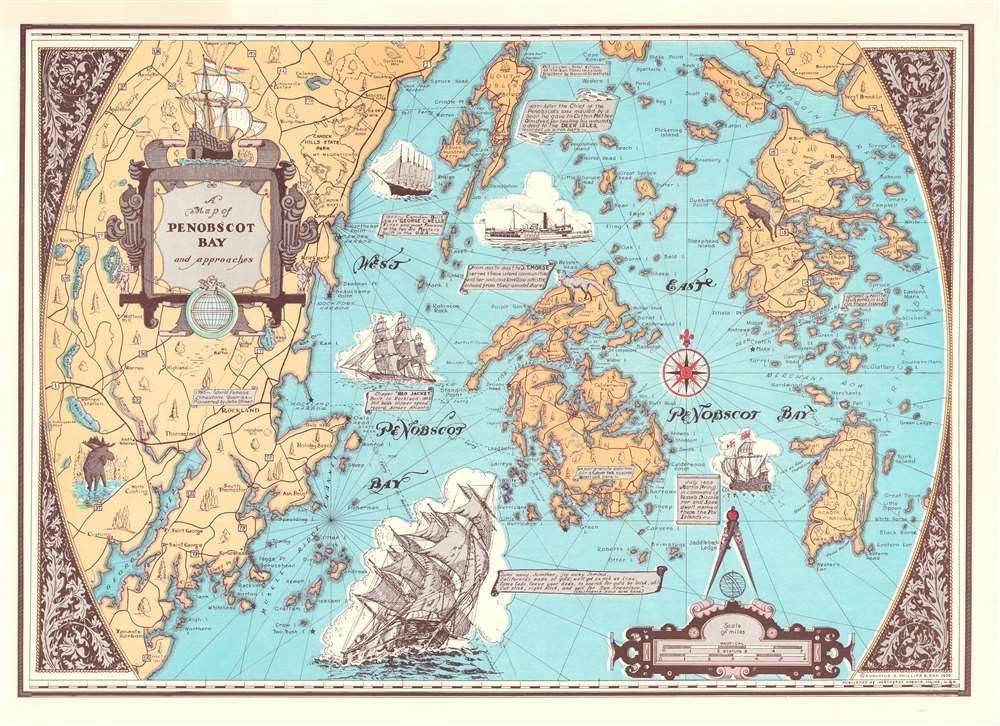

Title
A Map of Penobscot Bay and Approaches.
1970 (dated) 16.125 x 23 in (40.9575 x 58.42 cm) 1 : 108600
1970 (dated) 16.125 x 23 in (40.9575 x 58.42 cm) 1 : 108600
Description
This is a 1970 'Augustus Phillips and Son' pictorial map of Penobscot Bay, Maine. Islands throughout the bay are illustrated in detail, including North Haven, Deer Isle, Little Deer Isle, and the Isle au Haut. Maine's coastline appears in detail as well, with coves, harbors, points, and other landmarks noted. The highway network winds its way through the countryside. Vignette views of sailing ships from 1603 through the 20th century decorate the bay.
Publication History and Census
This map was created and published by Augustus D. Phillips and Son in 1970. We note two cataloged examples in OCLC: Osher Map Library at the University of Southern Maine and the University of Maine at Orono. We also note an example that is part of the collection at the Northeast Harbor Library in Northeast Harbor on Mount Desert Island.Cartographer
Augustus Dewey Phillips (May 6, 1898 - December 14, 1975), a.k.a. 'Gus', was an American artist, cartographer, and publisher. Born on Mount Desert Island, Maine, as a boy Augustus and his brother Luther Savage Phillips (1891 - 1960) helped their dad in a variety of odd jobs, including maintaining a boat rental business and harvesting and selling ice. Augustus graduated from Hebron Academy and then attended the University of Maine for a short time. After leaving university, Phillips became a Maine Guide and worked as a carpenter and draftsman in the South Portland and Boothbay Harbor ship and boat yards. The brothers traveled together widely throughout Maine. Luther went on to start a popular map and postcard business out of Northeast Harbor, Maine. After Luther died in 1960, Augustus took over the map businesses. In a tragic turn of events, in 1973 an out of control bush fire destroyed the Phillips studio and much of the surviving stock, making all Phillips' maps issued prior to that date rare. His passion for landscapes helped Augustus create his own map style. Augustus expanded the business and continued making new maps until he died in 1975. Augustus' son, Donald Beekman Phillips (1935 - 2009) continued the business after his father's death. Augustus married Mary Fletcher on April 26, 1922, with whom he had four children. More by this mapmaker...
Condition
Very good. Closed minor margin tears professionally repaired on verso.
References
Northeast Harbor Library MAP 0055 ADP. OCLC 182520141.