This item has been sold, but you can get on the Waitlist to be notified if another example becomes available, or purchase a digital scan.
1749 Seutter / Lotter Map of Pennsylvania, New Jersey and New York
PensylvaniaNovaJersey-suetter-1750$1,625.00

Title
Pensylvania Nova Jersey et Nova York cum Regionibus Ad Fluvium Delaware In America Sitis, Nova Delinatione ob oculos posita ...
1750 (undated) 22.5 x 19.5 in (57.15 x 49.53 cm) 1 : 1000000
1750 (undated) 22.5 x 19.5 in (57.15 x 49.53 cm) 1 : 1000000
Description
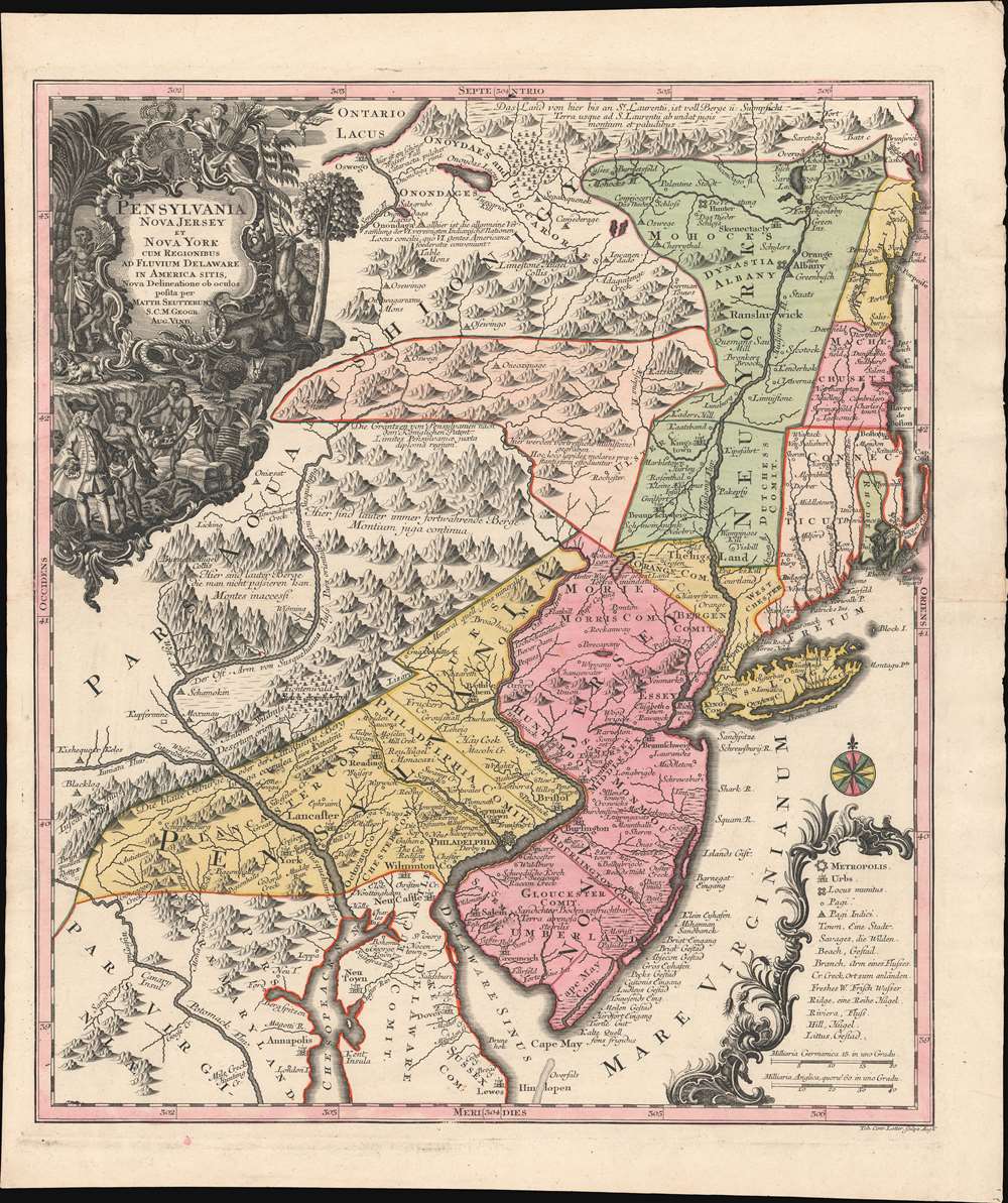
A c. 1750 example of Matthäus Seutter's map of the Middle Atlantic and New England regions during the British colonial period. It encompasses the Middle English Colonies, particularly New York, New Jersey, and Pennsylvania, capturing a period of rapid westward expansion and encouraging German emigration and settlement.
The image presented would have been enticing to the potential German immigrant. Wide navigable rivers penetrate deep into the interior. Mountains give way to fertile forests and valleys. Rich mines are readily available. The interior is dotted with accessible American Indian settlements - ready trading partners for the acquisition of pelts and other natural treasure. Moreover, German settlements on the Susquehanna and Hudson River tributaries were already established and - so the map would suggest - thriving.
The Lewis Evans Source Map
Cartographically, this map is heavily based upon the unobtainable 1749 Lewis Evans Map of Pennsylvania, New Jersey, New York, and the Three Delaware Counties. Although the lesser known of Evans' two maps, this was a significant work, being the first published map of the rural regions of eastern Pennsylvania and New York to benefit from actual survey work.Propagandizing German Immigration to America
With German immigration to America, particularly to the Lancaster region (Amish), there was a high demand in German markets for an accurate regional map. The Evans map was thus immediately pirated by an unknown Frankfurt publisher as, 'Special Land Charte von Pensilvanen...' The Frankfurt map was itself pirated in the same year by Matthäus Seutter and his son-in-law Tobais Conrad Lotter. While, neither Evans' map nor the Frankfurt variant achieved wide distribution and had extremely limited print runs, the prosperous Seutter firm disseminated it to a broad audience - marking this as the first generally available map to introduce the Middle Atlantic interior to a wide European audience.The image presented would have been enticing to the potential German immigrant. Wide navigable rivers penetrate deep into the interior. Mountains give way to fertile forests and valleys. Rich mines are readily available. The interior is dotted with accessible American Indian settlements - ready trading partners for the acquisition of pelts and other natural treasure. Moreover, German settlements on the Susquehanna and Hudson River tributaries were already established and - so the map would suggest - thriving.
Cartouche Celebrating Peace, Prosperity, and Bounty
The striking title cartouche in the upper left further drives home the map's message. It depicts William Penn, the founder of Pennsylvania, but also a Quaker (and thus religious outcast) and a pacifist. Penn is surrounded by flora and fauna - turkey, deer, rabbits, etc… and is shown trading on friendly terms with indigenous Americans. Unlike more traditional militantly themed cartouches, this large and imposing image communicates, peace, prosperity, and bounty.Broad Regional Context
Seutter expanded coverage over the Evans map to offer broader regional context. Unlike the Evan's source, Seutter incorporates New England and the British colonies of Rhode Island, Connecticut, Massachusetts, and New Hampshire. These areas are disproportionally reduced in size - doubtless intentionally - likely both to emphasize the vast 'unclaimed' inland territories, as well as to provide a more general regional context stressing access to New England commercial and maritime centers.Publication History and Census
This map is undated, but was likely first published in 1749-50. It was engraved by Tobias Conrad Lotter, Matthäus Seutter's son-in-law and soon-to-be heir. The map proved popular and enjoyed a long print run with multiple variant states. The present example is likely an early if not first state - bearing the Seutter imprint in the cartouche and Lotter's engraver signature in the lower right, just outside the border. The plate was used hard, and consequently many examples exhibit weak impressions and fuzzy printing - particularly in the densely engraved cartouche which suffered the greatest wear. Not so here, this fine impression exhibits the virtues of an early strike off the plate - e.g. crisp, sharp high-contrast lines. In 1756, following Seutter's death, Lotter replaced Seutter's imprint with his own, leaving the map otherwise unchanged. The map appeared both separately and in various editions of Seutter's Atlas Novus and Grosser Atlas. It is well represented institutionally but rarer in early states with the Seutter imprint.CartographerS
Matthäus Seutter (1678 - 1757) was one of the most important and prolific German map publishers of the 18th century. Seutter was born the son of a goldsmith but apprenticed as a brewer. Apparently uninspired by the beer business, Seutter abandoned his apprenticeship and moved to Nuremberg where he apprenticed as an engraver under the tutelage of the prominent J. B. Homann. Sometime in the early 1700s Seutter left Homann to return to Augsburg, where he worked for the prominent art publisher Jeremiad Wolff (1663 - 1724), for whom he engraved maps and other prints. Sometime around 1717 he established his own independent cartographic publishing firm in Augsburg. Though he struggled in the early years of his independence, Seutter's engraving skill and commitment to diversified map production eventually attracted a substantial following. Most of Seutter's maps are heavily based upon, if not copies of, earlier work done by the Homann and De L'Isle firms. Nonetheless, by 1731/32 Seutter was one of the most prolific publishers of his time and was honored by the German Emperor Karl VI who gave him the title of Imperial Geographer, after which most subsequent maps included the Avec Privilege designation. Seutter continued to publish until his death, at the height of his career, in 1757. Seutter had two engraver sons, Georg Matthäus Seutter (1710 - 173?) and Albrecht Carl Seutter (1722 - 1762). Georg Matthäus quit the business and relocated to Woehrdt in 1729 (and probably died shortly thereafter), leaving the family inheritance to his wastrel brother Albrecht Carl Seutter, who did little to advance the firm until in own death in 1762. Following Albrecht's death, the firm was divided between the established Johann Michael Probst (1727 - 1776) firm and the emerging firm of Tobias Conrad Lotter. Lotter, Matthäus Seutter's son-in-law, was a master engraver and worked tirelessly on behalf of the Suetter firm. It is Lotter, who would eventually become one of the most prominent cartographers of his day, and his descendants, who are generally regarded as the true successors to Matthäus Seutter. (Ritter, M. Seutter, Probst and Lotter: An Eighteenth-Century Map Publishing House in Germany., "Imago Mundi", Vol. 53, (2001), pp. 130-135.) More by this mapmaker...
Tobias Conrad Lotter (1717 - 1777) was a German engraver and map publisher. Lotter was the son of a baker and city guardsman, but married Euphrosina (1709 - 1784) Seutter, elder daughter of the prominent map publisher Matthäus Seutter. He began working at his is father-in-law's map business about 1740. Between 1740 and 1744 he produced, under Seutter's imprint, the Atlas minor, Praecipua orbis terrarum imperia, regna et provincias, Germania potissimum tabelli. Upon Seutter's death, in 1757, the firm's stock was taken over by his son, Albrecht Karl Seutter (1722 - 1762), who himself died in 1762, just a few years later. The remaining Seutter map plates were subsequently divided between Lotter and the publisher Johan Mitchell Probst (1727 - 1776). With the support of his sons, Matthäus Albrecht (1741 - 1810), Georg Friedrich (1744 - 1801) and Gustav Conrad (1746-1776), Tobias Conrad Lotter succeeded in building on the economic success and professional reputation of his father-in-law. In time, Lotter became one of the most prominent mid-18th century map publishers working in the German school. After Lotter's death in 1777, the business was taken over by his two eldest sons, who, lacking their father's business acumen, presided over the firm's slow decline. It was nonetheless passed on to a subsequent generation of Lotters, Matthäus Albrecht Lotter's sons, Gabriel (1776 - 1857) and Georg Friedrich (1787 - 1864), who pushed it into further decline until it faded out in the early-19th century. Learn More...
Condition
Very good. Crisp strong impression suggests an early strike off the plate. Full margins.
References
Rumsey 0173.001 (1753 edition). McCorkle, B. B, New England in Early Printed Maps 1513 - 1800, #750.4. Boston Public Library, Leventhal, #G3790 1756 .L68.