This item has been sold, but you can get on the Waitlist to be notified if another example becomes available, or purchase a digital scan.
1747 Bowen Map of Persia (Iran, Iraq, Afghanistan)
Persia-bowen-1747$225.00

Title
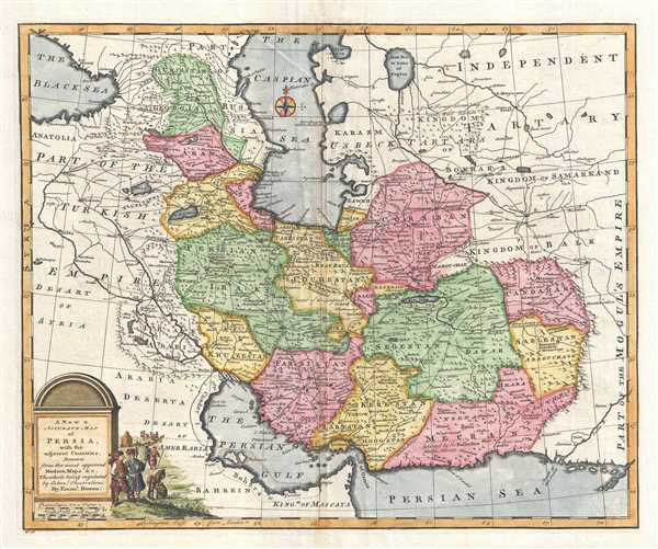
A New and Accurate Map of Persia, with adjacent Countries.
1747 (undated) 14.25 x 17.25 in (36.195 x 43.815 cm) 1 : 7500000
1747 (undated) 14.25 x 17.25 in (36.195 x 43.815 cm) 1 : 7500000
Description
This is a 1747 Emanuel Bowen map of Persia. An advanced map for the era, it depicts the region from Turkey (Anatolia) and Black Sea to Central Asia and the Indus River and from the Caucasus, the Caspian Sea, and Central Asia to the Arabian Sea, the Persian Gulf, and Arabia and comprises such modern-day countries of Iran, Iraq, Afghanistan, Pakistan, Russia, Georgia, Armenia, and Azerbaijan. Within Persia, provinces are illustrated, labeled, and shaded different colors to allow for easy differentiation. Myriad cities, towns, and villages are labeled throughout, including Mosul, Baghdad, Ispahan, Kandahar, and Kabul. Rivers are illustrated, including the Tigris and Euphrates, along with mountains throughout the entire map. To the west of Persia, part of the Turkish Empire is illustrated, complete with cities, roads, rivers, and mountains. The city of Palmyra is present, along with Mosul and Baghdad. A decorative title cartouche, featuring a scene of a traveling caravan, is situated in the lower left corner.
This map was created and published by Emanuel Bowen in 1747.
This map was created and published by Emanuel Bowen in 1747.
Cartographer
Emanuel Bowen (1694 - May 8, 1767) had the high distinction to be named Royal Mapmaker to both to King George II of England and Louis XV of France. Bowen was born in Talley, Carmarthen, Wales, to a distinguished but not noble family. He apprenticed to Charles Price, Merchant Taylor, from 1709. He was admitted to the Merchant Taylors Livery Company on October 3, 1716, but had been active in London from about 1714. A early as 1726 he was noted as one of the leading London engravers. Bowen is highly regarded for producing some of the largest, most detailed, most accurate and most attractive maps of his era. He is known to have worked with most British cartographic figures of the period including Herman Moll and John Owen. Among his multiple apprentices, the most notable were Thomas Kitchin, Thomas Jeffreys, and John Lodge. Another apprentice, John Oakman (1748 - 1793) who had an affair with and eventually married, Bowen's daughter. Other Bowen apprentices include Thomas Buss, John Pryer, Samuel Lyne, his son Thomas Bowen, and William Fowler. Despite achieving peer respect, renown, and royal patronage, Bowen, like many cartographers, died in poverty. Upon Emanuel Bowen's death, his cartographic work was taken over by his son, Thomas Bowen (1733 - 1790) who also died in poverty. More by this mapmaker...
Condition
Very good. Even overall toning. Blank on verso.
References
Alai E. 226. LOC G7620 1747 .B6. OCLC 55615897.