1745 Mannevillette First Edition Map of the Persian Gulf
PersianGulf-mannevillette-1745$2,500.00

Title
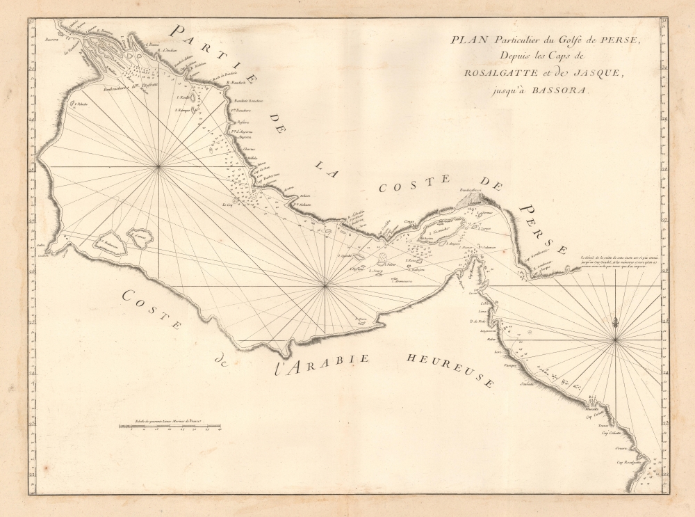
Plan Particulier du Golfe de Perse depuis le Caps de Rosalgatte et de Jasque, jusqu'à Bassora.
1745 (undated) 19 x 25 in (48.26 x 63.5 cm) 1 : 2000000
1745 (undated) 19 x 25 in (48.26 x 63.5 cm) 1 : 2000000
Description
This is the suppressed and thus extremely rare 1745 first edition of D'Après de Mannevillette's (1707 - 1780) groundbreaking map of the Persian Gulf. It is perhaps the earliest European map of the Persian Gulf based on actual navigation and is nearly unobtainable to the collector.
A Closer Look
The chart covers the Persian Gulf in full, from Basra on the Shatt al-Arab to the Gulf of Oman. Muscat (Mascatte) is identified as a settlement and safe anchorage. It includes the coasts of present-day Saudi Arabia, the United Arab Emirates, and northern Oman, and, in the northwest, coastal parts of Kuwait, Iran, and Iraq. The map offers the greatest detail on the Persian coastline, where there are numerous depth soundings, several forts, and trade cities noted, including Banderabassi, Congo, Laste, Basitu, and Bassora (Basra). The Arabian side of the gulf is less well mapped. Two islands are significant: Baharem (Bahrain) and Samac, the latter a mismapping of peninsular Qatar as an island. This is likely the earliest such map to make this error, which was followed by Carsten Niebuhr (1765), d'Anville (1775), and Bellin (1776). Mannevillette, like most other European navigators, did not visit the western Gulf coast due to an abundance of coral reefs blocking access for deep-draft ocean-going ships. Instead, he received reconnaissance from local nakhudas (skippers) who freely navigated the area in shallow-draft dhows.A Censored First Edition
All maps from the 1745 first edition of the Neptune Oriental are as significant as they are rare. The atlas followed Mannevillette's 1728 voyage to China, wherein, using the most up-to-date hydrographic instruments, he corrected latitudes and made new charts all along the route. When he returned to France, he devised a plan to publish new maps of the route to China, including charts of the Persian Gulf, the Red Sea, the coasts of India, Malaya, the northern parts of Indonesia, Indochina, and China. His Neptune Oriental, published for the Compagnie des Indes (French East India Company), appeared in 1745 and featured twenty-five groundbreaking maps. In reviewing the work, the French Admiralty considered the information to be so accurate and advanced over earlier charts that it threatened French colonial and maritime interests in the Far East. According to Filliozat, 'the French Admiralty considering that the Neptune Oriental was too dangerous... navigation, ordered the remaining copies to be destroyed' (Filliozat, Manonmani, Indian Journal of History of Science, 292, 1994, p. 341). Consequently, despite much revised and expanded issues of the Neptune Orientale appearing in 1775 (59 maps) and 1775 - 1781, the important first edition remains exceedingly rare. While the 1775 edition is common, we note only three surviving examples of the 1745 edition in the OCLC.Publication History and Census
This map was engraved by Guillaume d'Heulland for the 1745 first edition of D'Après de Mannevillette's Neptune Oriental. Like all the maps from this edition, most examples were confiscated and destroyed. The map was replaced in the 1775 second edition of the Neptune Oriental with a completely new Persian Gulf map based upon the navigations of René Julien Le Floch de la Carrière (1730 - 1792). We see examples of the separate chart only at the Bibliothèque nationale de France. The full 1745 edition of the atlas is known at the Library of Congress and the Bibliothèque nationale de France.CartographerS
Jean-Baptiste Nicolas Denis d'Après de Mannevillette (February 11, 1707 - March 1, 1780) was a French sailor, navigator, and hydrographer active in the mid-18th century. Mannevillette was born in Le Havre to a family of wealthy seafarers. He completed his first major voyage at 12, when he accompanied his father, Jean-Baptiste-Claude d'Après de Blangy, a captain of the Compagnie des Indes (French East India Company) vessel Solide to Bengal. On his return to France, he he studied mathematics and navigation in Paris under Joseph Nicholas De L'Isle (1688 - 1768) before returning to the sea at 19 as a fourth officer as on the merchant vessel Marechel d'Estrees. Mannevillette himself eventually attained the rank of Captain with the Compagnie des Indes. In the course of numerous voyages around Africa to India and China, Mannevillette collected and revised numerous nautical charts. His sophisticated use of the most modern instruments, most specifically the Octant or English Quarter, and keen mathematical mind, enabled Mannevillette to correct many significant errors common to earlier maps. These updates were eventually compiled and published in Mannevillette's most significant work, the 1745 Le Neptune Oriental. The 1745 Neptune Oriental was commissioned by the Compagnie des Indes and its production earned Mannevillette admission into the Academy of Sciences. The atlas was well received, but shortly after publication, most unsold examples were destroyed by the French Admiralty, who considered the secrets of East Indian navigation too dangerous for dissemination. In 1762 the Compagnie des Indes appointed Mannevillette director of chart at Lorient. In 1767 King Louis XV conferred the Order of St. Michael upon him and made him an associate of the Royal Marine Academy. In the 30 years following his first publication of Le Neptune Oriental, Mannevillette worked doggedly with his lifelong friend, Alexander Dalrymple (1737 - 1808) to update his original work with new and improved charts. In 1775, he republished his opus in a greatly expanded format - by this time nautical information was less tightly guarded. Mannevillette died on March 1, 1780 at 75 years of age. More by this mapmaker...
d'Heulland, Guillaume (c. 17?? - 1770) was a prolific French engraver active in Paris during the mid-18th century; his known work spans from 1731 to 1766. Most of his work focuses on maps, scientific diagrams, and architectural plans. He engraved nautical charts for the French Royal Navy; he engravred many maps and charts for Bellin, as well as for Charlevoix, Cassini, and Prevost. He appears to have engraved most, if not all of the charts for D'Après de Mannevillette's 1745 Neptune Oriental. He is perhaps best known for his 1756 Plan of Paris. The engraver Choffard was one of his apprentices. Learn More...
Source
D'Après de Mannevillette, Neptune Oriental, (Paris) 1745.
Le Neptune Oriental was a large-scale maritime atlas first issued in 1745 by Jean-Baptiste Nicolas Denis d'Après de Mannevillette, a wealthy French sailor and hydrographer. From his first voyage as an adult in 1726, Mannevillette collected, revised, and created new nautical charts. These he published 20 years later in the first edition of Le Neptune Oriental, an important work issued for the Compagnie des Indes (French East India Company), for whom Mannevillette was a captain. The first edition of Le Neptune Oriental containing 25 charts, was received and earned him accolade on both navigational and scientific circles. Nonetheless, according to Manonmani Filliozat, writing in the Indian Journal of the History of Science,
The French Admiralty considering that the Neptune Oriental was too dangerous ... ordered the remaining copies to be destroyed. (#292, 1994, p. 341)This accounts somewhat for the extreme scarcity of the first edition and all of the maps contained therein. We also note a supportive comment in a, 1763 catalog of maps and charts issued by the French chart and map dealer Roch-Joseph Julien (1745 - 1779). Mannevillette nonetheless continued to collect and revise charts for the next 30 years, often working with the important English cartographer Alexander Dalrymple (1737 - 1808). In 1775, he issued greatly expanded and updated second edition of Le Neptune Oriental. This time with an additional 41 charts, making a total of 63 charts. This edition also proved popular and was widely disseminated. As noted by multiple cartobibliographers, there are variations between examples and no two seem to be identical, suggesting that many were compiled to order, often with additional maps that could be purchased but which were not in the standard collation. The second edition was published in Paris by Demonville and in Brest by Malassis. In 1781, one year after Mannevillette's, another work, Supplement au Neptune Oriental was issued, also by Demonville and Malassis.
Condition
Very good. The chart has been trimmed to the neatline and laid down on period paper - likely by the original binder. No loss.
References
Bibliothèque nationale de France, département Cartes et plans, GE DD-2987 (6746).