
This item below is out of stock, but another example (left) is available. To view the available item, click "Details."
Details
1867 Mitchell Map of Colombia, Venezuela, Guiana, Peru, Ecuador, and Argentina
1867 (dated) $100.00
1872 Mitchell Map of New Granada, Venezuela,Guiana, Peru,Equador (Ecuador) and Argentina
PeruArgentinaVenezuela-mitchell-1872$50.00

Title
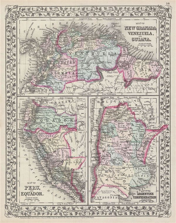
Map of New Granada, Venezuela and Guiana. Map of Peru, and Equador. Map of the Argentine Confederation.
1872 (dated, but date cut off) 15 x 12 in (38.1 x 30.48 cm)
1872 (dated, but date cut off) 15 x 12 in (38.1 x 30.48 cm)
Description
A beautiful example of the American map publisher Samuel Augustus Mitchell Jr.'s 1872 three map sheet depicting parts of South America. The first map shows New Granada (Columbia), Venezuela and Guiana. The second map, in the lower left quadrant, depicts Peru and equador (ecuador). The third map, in the lower right quadrant, features the Argentine Confederation
Simon Bolivar's vision of Gran Columbia was proven untenable and in 1829 and 1839, respectively, Venezuela and ecuador became independent nations leading to period of political upheaval and civil war throughout the region. Venezuela dissolved in the bloody Federal War (1859-1863) in which a significant percentage of the population perished. Colombia became the Confederación Granadina, a short lived federal republic that consisted of modern day Colombia and Panama. The Confederación, facing strong opposition from both liberal and conservative elements, dissolved in 1863 in the midst of the Colombian Civil War (1860 – 1862).
This map also identifies various cities, towns, rivers and an assortment of additional topographical details. Map is color coded according to political boundaries with elevation rendered by hachure. One of the most attractive American atlas maps of this region to appear in the mid-19th century. Features the vine motif border typical of Mitchell maps from the 1866 - 1882 period. Prepared by S.A. Mitchell for inclusion as plate nos. 58 in the 1872 issue of Mitchell's New General Atlas. Dated and copyrighted, 'entered according to Act of Congress in the Year 1872 by S. Augustus Mitchell in the Office of the Librarian of Congress at Washington.'
Cartographer
Samuel Augustus Mitchell (March 20, 1792 - December 20, 1868) began his map publishing career in the early 1830s. Mitchell was born in Bristol, Connecticut. He relocated to Philadelphia in 1821. Having worked as a school teacher and a geographical writer, Mitchell was frustrated with the low quality and inaccuracy of school texts of the period. His first maps were an attempt to rectify this problem. In the next 20 years Mitchell would become the most prominent American map publisher of the mid-19th century. Mitchell worked with prominent engravers J. H. Young, H. S. Tanner, and H. N. Burroughs before attaining the full copyright on his maps in 1847. In 1849 Mitchell either partnered with or sold his plates to Thomas, Cowperthwait and Company who continued to publish the Mitchell's Universal Atlas. By about 1856 most of the Mitchell plates and copyrights were acquired by Charles Desilver who continued to publish the maps, many with modified borders and color schemes, until Mitchell's son, Samuel Augustus Mitchell Junior, entered the picture. In 1859, S.A. Mitchell Jr. purchased most of the plates back from Desilver and introduced his own floral motif border. From 1860 on, he published his own editions of the New General Atlas. The younger Mitchell became as prominent as his father, publishing maps and atlases until 1887, when most of the copyrights were again sold and the Mitchell firm closed its doors for the final time. More by this mapmaker...
Condition
Very good. Minor overall toning. Blank on verso.
References
Rumsey 2483.044 (1870 edition).